This exercise presents a data development and management workflow that can be applied in all areas of the United States that are covered by the Soil Survey Geographic Database (SSURGO). The development of this methodology grew out of work with staff at Mississippi State University (MSU) in the Precision Agriculture Program. This work showed the need for current, fully attributed soil data at a county level.
The United States Department of Agriculture (USDA) manages SSURGO, one of the world’s largest collections of natural resource soil information. For years, USDA soils were mapped using geopolitical boundaries, often county boundaries. Today, SSURGO soils are typically mapped using the US Geological Survey (USGS) National Hydrography Dataset (NHD) Hydrologic Unit Code (HUC) subbasin boundaries. (To learn more about SSURGO, see the accompanying article, “Too Many Acronyms but Lots of Value.”)
The USDA SSURGO soils data is available for download by watershed area using an ArcGIS Online feature service. For many years, county agricultural service agencies and farmers prepared soil maps for individual counties. Since county boundaries and NHD subbasin boundaries seldom coincide, the first step will be to identify all subbasins within the desired county to create a county map.
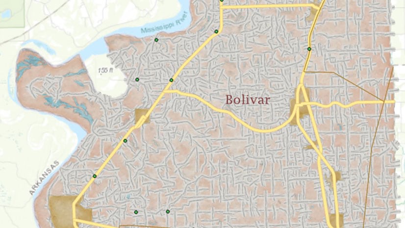
In November 2019, ArcGIS Online began hosting a new service that accesses updated SSURGO data by subbasin. This new service will be used to download and model data for Bolivar County, located in western Mississippi, just east of the Mississippi River.
This workflow includes:
- Identifying and acquiring all subbasins and soils that intersect Bolivar County.
- Clipping SSURGO soils to exact subbasin limits.
- Merging clipped subbasins for the area that covers the entire county.
- Clipping the merged basins to the county boundary.
- Applying a standard USDA thematic soils legend.
The sample dataset for this exercise includes an enhanced version of the basemap created in the previous exercise in “Making a Precision Reference Map in ArcGIS Pro,” in the Fall 2019 issue of ArcUser. Use this copy of the basemap.
Download the sample dataset from esri.com/arcuser and unzip on a local machine. If you have retained the previous exercise dataset, the new dataset for this exercise has been renamed and will not overwrite it.
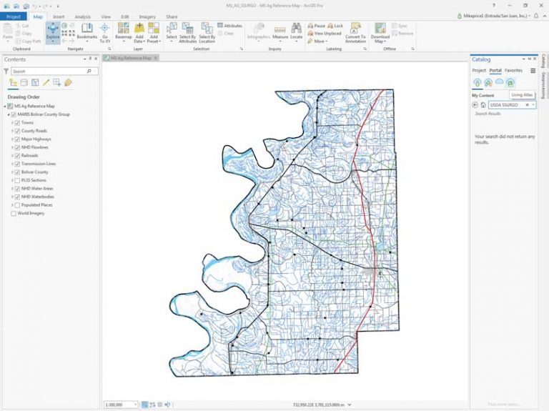
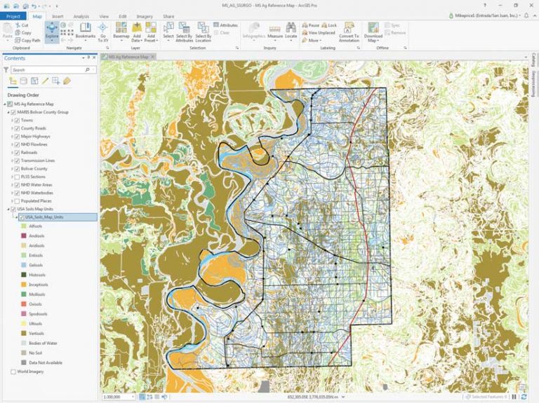
Start ArcGIS Pro, navigate to MS_AG_Technology, and open MS_AG_SSURGO.aprx. Inspect the MS Ag Reference Map of Bolivar County, which was built using vector data downloaded from the Mississippi Automated Resource Information System (MARIS) data site.
Set World Imagery as the basemap layer. Imagery will highlight the relationships between high-resolution data on soils, natural vegetation, and agricultural use that will be analyzed in this exercise. However, for the next steps, turn the imagery basemap off.
Locating and Accessing SSURGO Services
If not already logged in, log in to your ArcGIS Online account and open the Catalog pane of ArcGIS Pro. Select Portal > Living Atlas. Type “USDA SSURGO” in the Search box. Many SSURGO services are available. Locate the USA Soils Map Units that is a map image layer, which should be near the top of the search results. By aligning this image layer with the World Imagery basemap, you can monitor and verify soil downloads, checking both extent and symbology. Before loading the image layer, hover the cursor over other USA Soils Map Units services, including the feature layer, web map, and a hosted tile layer.
Return to the top of the list, right-click the map image layer, and select Add to Current Map. Position this layer above World Imagery and expand its legend. Look at Table 1: USDA Soil Order Classification System, which provides more information about USDA soil naming conventions.
Make the soils image partially transparent (Appearance tab > Effects > Layer transparency) and compare soils to the underlying aerial imagery. Click this imagery layer to access pop-ups that provide information about specific soils. Use the Bolivar County, MS 1:300,000 bookmark to return to the full Bolivar County extent.
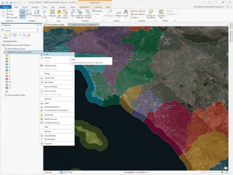
Now, add the SSURGO Downloader Subbasins service. This application provides quick access to ready-to-use map packages filled with useful soil data derived from the SSURGO dataset.
Return to the Catalog pane search, click the All Portal cloud, and type “ssurgo downloader” in the Search box. Locate SSURGO Downloader Subbasins, right-click its name, and select Add And Open.
SSURGO Downloader Subbasins will open in a new map, zoomed in to Southern California. Copy this layer into MS Ag Reference Map by right-clicking SSURGO Downloader Subbasins (choose the web map, not the feature layer) and selecting Copy.
Return to MS Ag Reference Map, right-click on its name in the Contents pane, and select Paste. Place the SSURGO Downloader Subbasins layer above the USA Soils Map Units layer (which should be turned off) and open its legend.
Right-click SSURGO Downloader Subbasins and open its attribute table. Save the project. For more information on SSURGO, subbasins, and the SSURGO Subbasins Downloader, read the accompanying article “Too Many Acronyms but Lots of Value.”
Acquiring SSURGO Data for Subbasins
Before downloading any data, set up Environments. Click the Analysis tab and click Environments. Verify that SSURGO_Soils.gdb is set as the Current and Scratch Workspace and that Output Coordinate System is set to WGS_1984_UTM_Zone 15N. Set the Processing Extent to Same As Layer > MARIS Bolivar County Group/Bolivar County. Click OK to update Environments.
The next step is to select all the sub-basins in Bolivar County. On the Map tab, click Select by Location. The Geoprocessing pane opens. Click the Select by Location pane and set SSURGO Downloader Subbasins as the Input Features. Define an Intersect Relationship, set Bolivar County as Selecting Feature, and click Run. The four selected subbasins should be Lower Mississippi-Greenville, Deer-Steele, Big Sunflower, and Lower Mississippi-Helena.
In the attribute table, select Show Selected Records, and sort the records in ascending order by SUBBASIN. Highlight and inspect the Big Sunflower record. Carefully study the Subbasin_name and Link fields. You must use the subbasin name when downloading and saving SSURGO data. At the top of the Contents pane, switch to List by Selection and make only SSURGO Downloader Subbasins selectable. On the Map tab, open the Explore icon drop-down and check Selectable Layers. This small step is very important. Save the project.
To map all Bolivar County soils will require downloading and carefully managing four subbasin datasets. This is the process you will use for each subbasin.
- Select the Explore tool and left-click inside Big Sunflower, the large highlighted subbasin that covers much of the state.
- Study the Big Sunflower pop-up. The information in the pop-up indicates that there are two ways to capture soils data: either as a Download project package or as a Map package. Since the Download project package accesses newer data, choose it.
- Left-click the Download link. Your default browser will open. Choose to open BigSunflower 08.ppkx with ArcGIS Pro. A new ArcGIS Pro project named BigSunFlower_08030207 opens over your current ArcGIS Pro project.
- Zoom to the Subbasin layer.
- This entire map will be copied into the MS_AG_SSURGO project, but three items in this new project must be renamed first. In the Contents pane, change the names of the following layers by right-clicking and accessing Properties.
- Rename the map to BigSunflower, rename Subbasin to NHD BigSunflower, and rename Mapunits to SSURGO BigSunflower. Type these names exactly as shown. Use only alpha characters in the subbasin name, and don’t use hyphens.
- Save the project.
After renaming those three items, open the Catalog pane in the new project and expand Maps. Highlight BigSunflower, right-click it, and select Copy. Return to the MS Ag Reference Map project and in the Catalog pane, expand Maps, right-click it, and select Paste.
NHD and SSURGO layers need to be copied into MS Ag Reference Map. Starting with BigSunflower, select both NHD and SSURGO layers, right-click, and select Copy. Return to MS Ag Reference Map, right-click its title (MS Ag Reference Map) and select Paste. Save the MS_AG_SSURGO project. Close the BigSunFlower_08030207 ArcGIS project.
Return to MS Ag Reference Map. For three other subbasins—DeereSteele, LowerMississippiGreenville, and LowerMississippiHelena—repeat the previous process (select; download; extract; rename Map, Subbasin, and Mapunits with the subbasin name; copy the map in the new ArcGIS project; and paste into MS Ag Reference Map. Then copy the NHD and SSURGO layers and paste into the MS_AG_SSURGO project. Save the project after adding the map and layers for each subbasin.
Managing Maps
When you have finished downloading and copying over all four subbasins, reorder the layers with NHD layers first and then all SURGO layers. Place all eight layers in a Group Layer and name it SSURGO Import Group. Make sure the soils layers for each SSURGO layer are listed in this order:
- Alfisols
- Bodies of Water
- Data Not Available
- Entisols
- Inceptisols
- Mollisols
- No Soil
- Vertisols
Turn on the the World Imagery basemap and try using the Swipe tool to compare it to the soils layers. If you know the area, zoom to a favorite farm or other location. Save the project again.
SSURGO Geoprocessing
If you carefully study each downloaded subbasin, you will likely see soil polygons that extend outside NHD subbasin boundaries. Merging the raw subbasin data would likely create overlap polygons along basin margins that would distort the resulting merged soils. For example, areal statistics by soil and acreage type would be rather inaccurate. To resolve this issue, clip and save only soils within a subbasin perimeter.
Before starting, clean up the project by removing all SSURGO maps (BigSunflower, DeerSteele, LowerMississippiGreenville, and LowerMississippiHelena) from the MS_AG_SSURGO ArcGIS project. Only MS Ag Reference Map and SSURGO Downloader Subbasins will remain. In the SSURGO Import Group layer, make NDH Big Sunflower and SSURGO Big Sunflower visible and make sure all other layers are turned off. Save the project.
In this step, the four soil datasets will be clipped to their NHD subbasin boundary.
- Open the Geoprocessing pane and type “clip” in the search area. Select Clip from the Analysis Tools.
- Set Input Features as SSURGO BigSunflower, set NHD BigSunFlower as Clip Features, and SSURGO_BigSunFlower_Clip as the Output Feature Class and store it in MS_AG_Technology\MS_AG_Technology\SSURGO\SSURGO.gdb. Make sure the output feature class name is exactly SSURGO_BigSunFlower_Clip, using underscores and no spaces.
- Remember that carefully using consistent naming conventions is critical. Click Run to execute the Clip tool. The SSURGO_BigSunflower_Clip layer will load at the top of the Contents pane. Turn the new layer off.
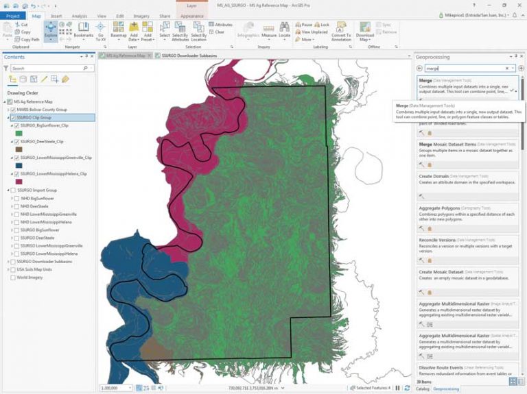
- Clip the remaining three SSURGO subbasin soils, using their respective NHD boundary layers, using the same procedure. Carefully name all output feature classes using the above procedure and assigning names with this format: SSURGO_<subbasin name>_Clip.
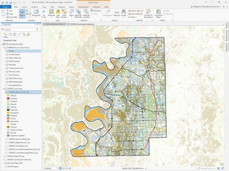
- When finished, group all four clipped subbasins in a group layer called SSURGO Clip Group. Notice that the Environments Extent setting has limited all clipped soils to the boundary for Bolivar County
Merging Clipped Subbasins
With all four subbasins clipped to their respective NHD boundaries, they can be merged into a single countywide polygon feature class. Since the SSURGO table structure is consistent across all US subbasin datasets, the extensive attribution for each dataset will be preserved. These merged subbasin datasets can then be clipped to the Bolivar County boundary.
Open the Geoprocessing pane and search for “merge” and choose Merge (Data Management Tools). Click the down arrow next to Input Datasets to add many datasets. Check the boxes next to all four clipped subbasins in the SSURGO Clip Group and click Add to add them. Set the Output Dataset path as MS_AG_Technology\MS_AG_Technology\SSURGO\SSURGO.gdb and name it SSURGO_Bolivar_Merge_Raw. Verify that Merge Rule is set to First and all SSURGO Clip Group\ parameters are set to areasymbol. Click Run to merge four soil sets. Once merged, inspect the SSURGO_Bolivar_Merge_Raw, place it in the SSURGO Clip Group, and save the project.
Clipping Merged Subbasins
Next, clip the merged SSURGO subbasins to the Bolivar County boundary. Reopen the Geoprocessing Clip tool and set SSURGO_Bolivar_Merge_Raw as Input Features. Set Clip Features to Bolivar County, then set Output Feature Class as MS_AG_Technology\MS_AG_Technology\SSURGO\SSURGO.gdb and name the output feature class SSURGO_Bolivar_Final_Clip. Click Run to perform the clip. When the clipped layer loads in the Contents pane, inspect it for accuracy and completeness. Move it to the top of the SSURGO Clip Group and save the project again.
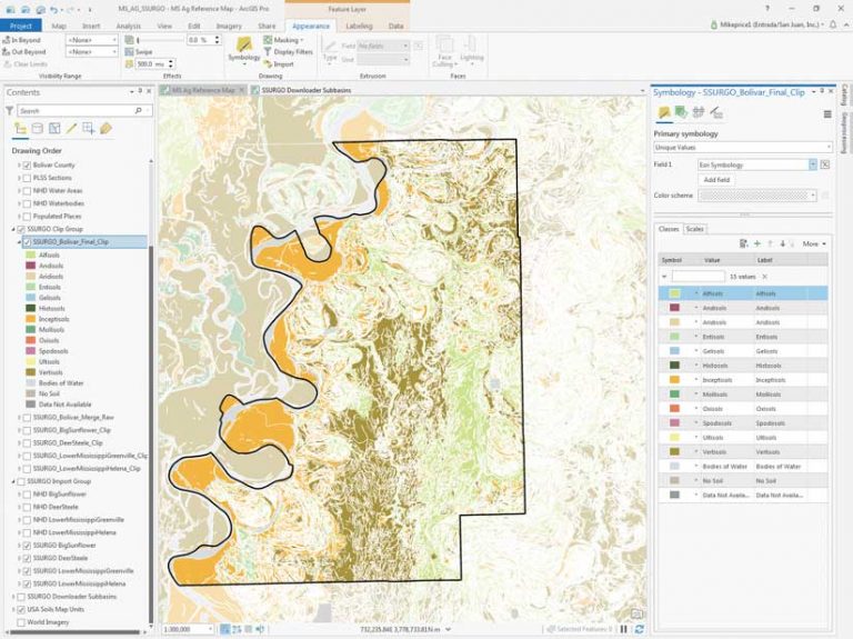
Symbolizing and Studying SSURGO Soils
Display the original USA Soils Map Units image and inspect its thematic legend. The SSURGO type names and thematic colors are assigned by an attribute named Esri Symbology. To replicate this symbology, borrow this legend from one of the ArcGIS Online maps that were downloaded earlier in a previous step in this exercise. However, there is no guarantee that the legend for an individual subbasin would include all mapped soil types. This would be especially true if soils were downloaded from another region.
Go to the bottom of the Contents pane and make the USA Soils Map Units image visible. To standardize thematic mapping, let’s use the layer file legend I created that will properly display downloaded SSURGO soil polygons from any location in the continental United States. After using this layer file to symbolize soils, compare them to the Soils Map image.
- To apply this layer file, right-click SSURGO_Bolivar_Final_Clip in the Contents pane and select Symbology.
- In the Symbology pane, left-click the Symbology menu tool (i.e., the three bars in the upper right corner) and select Import symbology. The Apply Symbology From Layer geoprocessing tool opens. Click the folder next to the Symbology layer and navigate to
\MS_AG_Technology\MS_AG_Technology\SSURGO and locate USA Soil sMap Units.lyrx. - Add this file to the tool and specify esrisymbology as the Source Field and Esri Symbology as the Target Field. Click Run. This will apply standardized SSURGO symbology to SSURGO_Bolivar_Final_Clip. Inspect the resymbolized Bolivar SSURGO layer. Inspect the polygon symbology assigned to soil types.
- Close the Symbology pane and save the project.
Updating and Inspecting Bolivar County SSURGO Soils
To complete this project, update the clipped soils and save a layer file that can load the symbolized feature class into any ArcGIS Pro map.
- In the Contents pane, rename SSURGO_Bolivar_Final_Clip to SSURGO Bolivar Co, MS Soils.
- Right-click the renamed soils and select Sharing, then Save as Layer File.
- avigate to the SSURGO folder and save the new .lyrx file next to USA Soils Map Units.lyrx.
- Move the MARIS Bolivar County Group above SSURGO Bolivar Co, MS Soils and turn on all layers except PLSS Sections and Populated Places.
Zoom to a 1:250,000 scale. In the MARIS Bolivar County Group, right-click Towns and turn on Labels. Use Find to locate the town of Symonds. Adjust the map scale to also see Clifford to the southeast. Open the attribute table for SSURGO Bolivar Co, MS Soils. Choose Select > Rectangle to select a small area between Symonds and Clifford. Show only selected records and click individual records to highlight them on the map.
Scroll to the right in this very wide attribute table to learn what soil types and conditions contribute to prime farmland. By looking at the attribute field Farmland Class, you can identify arable land and land categorized as not prime farmland. Look for attributes on flooding potential, clay content, poor drainage, runoff character, and other factors.
Inceptisols represent high clay areas and often include old river meander features. These are the soils to avoid. Use your creative mapping skills and tools such as Select by Attributes, as well as sorting and visualization, to identify other areas that might be eligible for set-asides as environmental easements, wild animal and bird habitat, or inclusion in biofiltration areas.
On Your Own
If you enjoyed this sophisticated and very practical exercise, consider creating a similar SSURGO soils model for your favorite county. Locate your home or family farm and check out the underlying soils. It is surprising how much you can learn about these soils.
Summary and Acknowledgments
This is a rather challenging and very real-world exercise. I’ve had fun exploring soils at my family’s properties—past and current—that are scattered across the west. Hopefully, you enjoy this search and interpret mission and have become quite skilled at data downloads from ArcGIS Online, geoprocessing, and file management.
Thanks to the fine staff members of the MSU Precision Agriculture Program for their encouragement as I developed this exercise. Special thanks to Dr. Amelia A. Fox, who happens to be my youngest sister and a very dedicated Skagit County, Washington, farmer who has been transplanted to the fine state of Mississippi.
Thanks, too, to the US Department of Agriculture and Esri staff who worked on the development and deployment of ArcGIS Online SSURGO soils, for all their fine efforts and for encouraging me to tackle this complex workflow.