
April 17, 2020 |
Christopher Thomas | GIS for Good
May 26, 2020
“Essential workers are risking their lives every day. The least we can do is help them to easily find childcare.”
That’s the voice of Joanne Markert, GIS coordinator for Washington state’s Office of the Chief Information Officer. While most Washington state residents follow Governor Jay Inslee’s Stay Home/Stay Healthy order, essential workers are reporting for duty and in need of childcare. For many, this poses a considerable challenge as all schools and many childcare facilities are currently closed.
After a survey of 156 after-school facilities showed fewer than one-third providing childcare services as of late March, staff at the state’s Washington Technology Solutions Office of the Chief Information Officer (OCIO) saw the disconnect and wanted to help.
Washington state, one of the first US epicenters of the coronavirus disease 2019 (COVID-19) outbreak, now reports more than 13,500 cases statewide. Given the fluid nature of the outbreak, childcare facilities that are open have constantly changing availability.
Collaboration to Build Childcare Dashboard
Markert and the GIS team created an online, map-based dashboard to show which facilities are open for childcare. Essential workers can use the interactive dashboard to select a school district and quickly see available facilities. They can also click on the individual facility to learn more details such as the name, address, email, phone number, county location, and hours.
Building the interactive map took collaboration across agencies using geographic information system (GIS) technology. The team at OCIO used ArcGIS Dashboards from Esri to create the interactive map. Staff at the Office of Superintendent of Public Instruction provided the underlying GIS data on schools and school districts. The State Emergency Operations Center provided additional information about hours of operations, specific email addresses, and phone numbers to contact, as well as alternative sites such as Boys & Girls Clubs working in partnership with the schools.
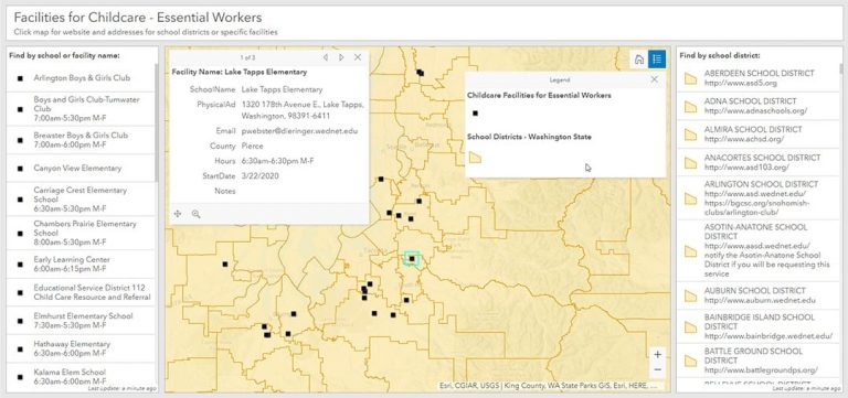
The public can access the dashboard on the Washington Geospatial Open Data Portal and the Washington Emergency Management Division web page. The dashboard provides workers with one authoritative source for the most current status updates.
“We hope that this dashboard alleviates a bit of stress for these folks during such a traumatic time,” Markert said.
Seattle Focuses on Small Businesses
Restaurants across the country are forecast to lose $225 billion in business over the next three months and five to seven million service and kitchen jobs, according to the National Restaurant Association.
In Seattle, city officials took early steps to provide for their local economy by launching the #SupportSeattleSmallBiz campaign—connecting citizens with local businesses. The program aims to keep businesses open and keep the workforce supporting them employed.
“We’re doing everything we can locally to support our small businesses during this unprecedented moment in history,” said Mayor Jenny Durkan, City of Seattle. “We’ve identified millions of dollars to invest directly in our most vulnerable small businesses and are working with our partners across government and in the private sector to help many who are struggling.”
To provide Seattle restaurants, cafés, and breweries with a way to share whether they are remaining open, the city’s information technology department launched a mapping application built with GIS. Business owners can use a simple survey form to populate the interactive online map with their information.
The solution includes a public-facing application that allows residents to enter their location or drop a pin on the map to find available restaurants near them. A Seattle resident can use the application to select a restaurant, view the business phone number, get a link to the website, or receive directions to pick up their takeout order. The app also connects residents to third-party delivery services if the restaurant does not deliver.
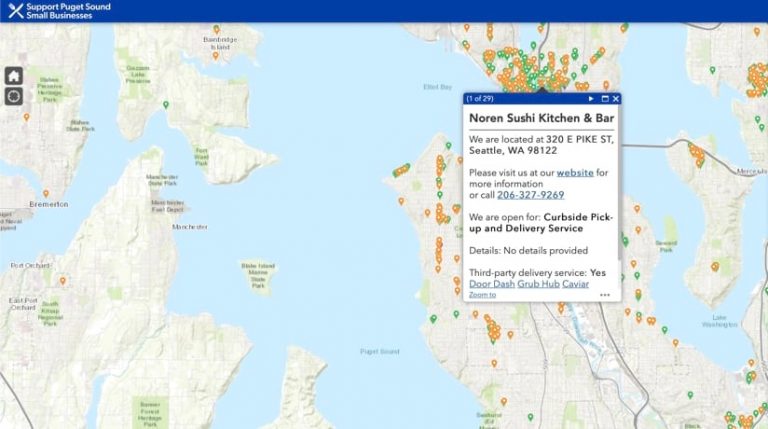
“With many of our neighborhood restaurants still open, we can support our small businesses by ordering pickup or delivery during this time,” Durkan said. “I’m grateful to our community partners who helped shape our map and make it a reality.”
On the day the application was launched, the city had information on over 500 businesses. By the third day, they had 300 more. Currently, the app has over 1,100 local Seattle businesses listed—and counting. Recently, the mapping app expanded to include restaurants countywide.
“We were shocked at the attention the campaign has received and at the number of views the map has received,” said Stephen Beimborn, manager of departmental GIS analysts for the City of Seattle. “This is a testimony to how well aligned our city government is with the local media, the business community, and Seattle residents on the importance of local businesses to the economy and the community, with the jobs they create and the vital services they provide.”
Buying Local to Save a Job, a Business, a Family
In times of crisis, communities often become more aware of the importance of buying local. Efforts to support small businesses in Seattle are helping sustain the local economy and empowering a virtuous chain reaction—employees keep their jobs; suppliers continue to deliver and support the supply chain; businesses can pay rent, taxes, and utility bills; residents spend money to stimulate growth.
Seattle city government is able to promote the #SupportSeattleSmallBiz initiative and connect residents to businesses by using GIS technology to collect, manage, map, and share all relevant information in the context of location.
“Reading the emails from restaurant owners has been the most rewarding aspect of the work,” Beimborn said. “As eager as they are to make sure their business is on the map, they never fail to thank us for our efforts. That’s all the incentive any of us have needed.”
See the COVID-19 GIS Hub for location intelligence resources. The Coronavirus Response solutions page provides a collection of maps and apps that can be used by agencies to understand the virus’s impact and share information about the pandemic with the public.