
December 14, 2020
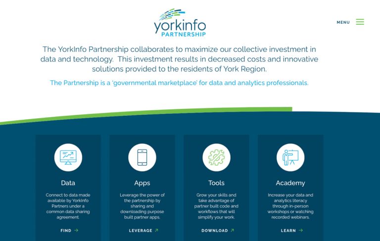
The Regional Municipality of York—Canada’s fastest growing municipality—has pioneered a collaborative, data-driven approach to local government that is gaining global esteem. The digital transformation provides the means for local governments across the rapidly changing region to share data and apps, and work together to better understand and serve residents.
Elements of the YorkInfo Partnership include direct data connections, app sharing, tools and computer code collaboration, and an academy with workshops for analytics professionals to improve their skills.
The idea to create a data cooperative to achieve efficiencies and eliminate data duplication isn’t new. “We found meeting minutes in our archives from 1977 that said we need to find a way to set up a utility for sharing our data,” said Jeff Lamb, manager of partnerships at York Region. “The concept has been there, and the technology caught up.”
Other local governments marvel at how resolving data-sharing bottlenecks has allowed York Region to apply advanced analytics to improve decision-making.
“We started thinking about what keeps senior management up at night,” said John Houweling, director of data analytics and visualization at York Region. “It’s about business drivers and problem-solving.”
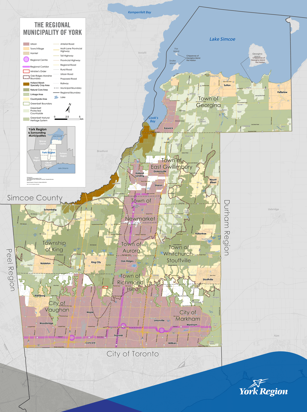
York Region has grown steadily to become the sixth largest municipality in Canada, with almost 1.2 million residents. With the constant additions of jobs, people, homes, and infrastructure, the local government relies on close collaboration to keep data current.
York Region combines a strong regional government with nine municipalities that collectively oversee transportation; mass transit; water, wastewater, and solid waste; policing; emergency services; housing; human services; and planning. Most of these services are managed in part by a geographic information system (GIS), which applies a location context in order to guide operations.
“Everything has either an address or it’s happening on a property, so it can be attached to our address points, parcels, and roads,” said Laura Thomas, GIS analyst at York Region. “We take a lot of business data and bring it into the spatial world.”
Though an enterprise technology architecture connects the systems that manage each service, the Region identified a need for people to become better connected as well.
“We need everyone to work together, because something like 60 percent of the data we rely on for Regional programs comes from local municipalities,” Lamb said. “It takes dedicated work to get people at the table and keep them there. Over time, we’ve found ways to break down barriers at all levels.”
Now, the data sharing has become routine.
“All the collaboration and partnerships are part of our ordinary daily work,” Thomas said. “It’s only when I go to a conference that I realize it’s a bit different than what everyone else is doing.”

The partnership formed in 1996, with York Region in the middle as the hub and municipalities as the spokes. Originally, it was purely about the exchange of GIS knowledge and data, and the exchanges were mostly between the Region and each municipality individually. In 2013, the first umbrella data-sharing agreement eliminated the back-and-forth of every data request, meaning that when a request was received, the data was simply delivered.
“The partnership agreement proved pivotal to making everyone feel more connected,” Lamb said. “Before that agreement, technology wouldn’t have solved the human barriers.”
One of the first Regional data efforts was to produce the All Pipes database, which aggregated infrastructure data from each of the nine municipalities. York Region provides water and wastewater distribution pipes, and then each municipality is responsible for transmission pipes to homes or businesses.
“We created data standards and a data model to bring all the data together,” Houweling said. “We’re now using that approach to create common data for different things—all streets, all parks, all whatever.”
There’s also an ongoing collaboration to capture the construction plans of each municipality together with a common viewer. It will allow everyone to see what their neighbors have planned or are thinking of doing. This visibility starts conversations to prevent disruptions or to combine efforts for cost reductions.
York Region applies a distributed collaboration approach, using a combination of ArcGIS technology to seamlessly share GIS content (maps, apps, layers) and more across partner organizations.
“The beauty of the technology is that we can connect and put our live production data up there and forget about it,” Thomas said. “Our processes are running, and the data stays connected and alive.”
The burgeoning Town of East Gwillimbury, one of the Region’s nine local municipalities, provided a proving ground for this next level of real-time data sharing. The town has traditionally issued 150 building permits per year. Last year, that total jumped to more than 1,000.
“It’s almost ridiculous how fast the town is growing,” Thomas said. “We need to know the occupancy of a new subdivision—and when people are moving in—as quickly as possible to provide new residents with services.”
Data comes in quickly to the co-op through a combination of GIS apps that East Gwillimbury staff use on phones and tablets to make updates and edits in the field.
“This means when the data is available to East Gwillimbury, it’s also available to the rest of us,” Thomas said. “Historically that would only happen monthly or if we asked East Gwillimbury staff to export it.”
The YorkInfo Partnership coordinates data purchases for the group and has successfully driven down costs due to this consolidation.
“We leverage our collective purchasing power as well as each other’s time and resources,” Lamb said. “With 14 partners in 1, we find savings we wouldn’t have found on our own.”
The new seamless pattern of sharing has given partners more autonomy, while also connecting each partner more closely to each other. Instead of top-down directives and guidance, the partners now serve themselves.
The collaboration also extends to knowledge sharing.
“It’s really been amazing to watch our partners lean on each other and share,” Lamb said. “It allows some of the smaller municipalities with just a one-person GIS shop to reach out to their 70 peers across the region who can help them be much mightier.”
With the economic impact of the COVID-19 crisis, Houweling thinks greater cooperation will become more of a priority for cost savings across all local governments. “Why don’t we just leverage what other people are doing? If you create a nice streetlight app, why wouldn’t you put that in the Data Co-op so that the other municipalities can quickly grab it and use it too?”
Enhanced data sharing has fostered more analysis to understand communities and tailor services to the people in each place.
“I’ve noticed more interest in things like walkability, how accessible services are, and how livable the community is,” Thomas said. “That wasn’t much of a focus a decade ago.”
While GIS is central to much of the management and planning work at York Region, the technology was put in a wider frame by renaming the branch to Data Analytics and Visualization Services. This recent move was accompanied by a 4-year road plan—a data and analytics strategy—for the whole organization. PricewaterhouseCoopers was brought in to help create the road map and work with the different data groups across the Region.
“Focusing on analytical outcomes—that’s how you get senior management buy-in,” Houweling said. “Instead of focusing on millimeter accuracy for sewer pipes and other infrastructure, we focus on getting data good enough and using it. Our goal is to ensure our data is accurate, trusted and accessible to provide the highest value in any situation.”
The new branch name marks a shift toward a solutions-oriented mind-set focused on the capabilities of data analysis and visualization.
“It’s so much better when the impetus for creating solutions comes from our business partners and is aligned to their needs, rather than from the GIS side,” Thomas said. “Otherwise, we’re just GIS nerds trying to push technology. Once the business sees it and the business understands it, we’re golden.”

GIS has expanded organization-wide and several new hires now support the Region with advanced analytics. “Data scientists are mining data and doing all kinds of things I can barely conceptualize,” Thomas said.
Tackling the first step in its 4-year plan, leaders from York Region are now working to supplement their enterprise spatial data warehouse with an enterprise data and analytics platform. This system will deliver a geographic context to a wider number of municipal service providers and additional levels of government.
“We’re not everywhere we need to be yet, but we’ve figured out the formula,” Houweling said. “When Jack Dangermond gave us the President’s Award at the 2020 Esri User Conference, he said, ‘Only the people that have done these sorts of things—who have added the social grease—know what it takes.’ I really love that, because it summarizes our people-centric partnership.”
Learn more about the enterprise approach that powers location intelligence.