Every city has a unique story to tell, but lately, the stories of the biggest cities have begun to sound the same: they appear to be running out of room to grow. But are they? How fixed are their limits?
At its current pace of growth, San Francisco will approach the limits of existing zoning sometime after midcentury. If you are an individual or own a business with connections to California’s Bay Area, this fact might seem curious but remote—a morsel traded during dinner party conversations. As a long-range urban planner for the City and County of San Francisco, however, I think about it often—and with growing interest.
It raises three fundamental challenges for long-range planning: (1) determining how much more growth makes sense and is desirable; (2) choosing the methods, tools, criteria, and stakeholders for the assessment and decision; and (3) conducting the rezoning and cross-agency planning to add the capacity, including the infrastructure and conditions, required for a high-quality city.
Cities have always served as dynamic centers of commerce. They fuel job creation, entrepreneurship, and innovation—the characteristics that draw people to them. In the best cases, they also produce richly attractive and vital cities. However, the simple fact is that physical systems cannot grow forever. For the cities that are growing out of currently zoned capacity, there is heightened pressure for city planning to continue enabling and accommodating physical growth (especially jobs). The pressure arises from the belief that the associated prosperity for both people and businesses will continue even as physical limits are approached.

Smart planning and growth that take advantage of smart technologies will become the foundations for business success, inclusive prosperity, and community well-being.
Instead, there will be declining quality of life and prosperity when growth begins to exceed required infrastructural capacity.
Thus, the core long-range planning challenge is how to design the cities of tomorrow so that they can prosper and provide a rich urban experience even as the limits on current growth and infrastructural capacity are approached.
Planning in an Increasingly Urban World
Today, half the world’s population live in urban areas, and by 2050, at least two-thirds will live in cities.1 If San Francisco and other metropolitan areas around the globe use up existing growth capacity sometime in the decades ahead, will our only option be to stop growing inside our cities and sprawl outside them?
Our response to that fundamental question will affect businesses and residents in profound ways. For San Francisco, the Bay Area, and regions worldwide, the innovation needed to address these challenges begins with smarter planning. We must normalize innovation, retire outdated mind-sets, invent new practices, ask better questions, enlist the right tools, and rally effective partners.
Smarter planning and growth that take advantage of smarter technologies will become the foundations for business success, inclusive prosperity, and community well-being in the twenty-first century and beyond.
The Boomtown Challenge
In San Francisco and other metropolitan areas, surging job growth, lagging housing development, and declining growth capacity have created boomtown dynamics that are driving costs sky-high, increasing congestion and resource competition, and straining residents and businesses alike.
We need to ensure that San Francisco and other boomtown cities do not respond to these challenges by simply repeating the historical pattern of sprawling urban and regional development.
To maintain the essential soul, character, and culture of our cities, planners must design cities that are attractive for living and working, as well as make them affordable for everyone across the income spectrum.
Today’s housing prices in San Francisco make many people wince. The average home value in May 2012 was $677,000. Five years later, it had risen 76 percent to $1.19 million, according to Zillow.2 Rental costs for office space have followed a similar trajectory, doubling to nearly $80 per square foot from 2013 to 2016.3 In 2016, the national average was just under $44 per square foot.4
In San Francisco, as in most cities, the challenges of affordability and planning are not ours alone. They are shared by the surrounding San Francisco Bay Area, which includes the cities of Oakland and San Jose and tech locales like Cupertino, Menlo Park, Mountain View, and Palo Alto. In 1950, the population of the San Francisco Bay Area was 2.7 million. Thirty years later (1980), that number had nearly doubled (93%) to 5.2 million residents. Today, 7.7 million people call the Bay Area home, while the regional Plan Bay Area (PBA) forecasts a total of 9.6 million residents by 2040 (250% over 90 years, or an average yearly growth of about 3%, or 77,000 residents).5
Those numbers tell the high-growth story of regional expansion, while the numbers for the City and County of San Francisco tell another—that of slower and variable growth: increasing to 775,000 residents at the midpoint of the twentieth century; declining 12 percent to just 679,000 by 1980 (reflecting a national trend—the exodus of jobs and residents from the central cities to the suburbs); and increasing 28 percent to an estimated 871,000 in 2016 (from 1980, or 12% since 1950), with the regional PBA anticipating growth to 1.16 million residents by 2040 (up 50% over 1950). San Francisco has grown more slowly not because it is unpopular but because it is constrained by geography—we pack more people into each square mile than any other US city besides New York. That scarcity—and the growing popularity of the area—breeds high prices all around.
And yet businesses and residents continue to gravitate to our commercial opportunities and quality of life. This intensifies pressure on each city in the region to effectively plan for 20-, 30-, and 40-plus-year growth.
From Greenfields to Infill
To engage in smart planning as an effective response to the growth challenge, we need to abandon the old mind-set of easy, cheap, and abundant greenfield development. Gone are the days when developers, businesses, and municipalities could dream up a project, select a prime plot of undeveloped land, and bring it to life.

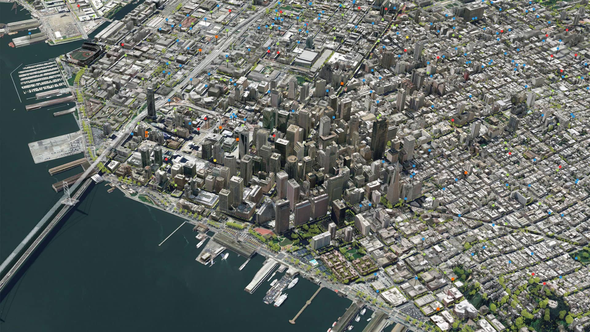
Today's advanced GIS software can now model cities in 3D and integrate the full planning workflow, thereby dramatically enhancing efficiency and effectiveness.
In crowded urban environments, the greenfield mentality has yielded to a new refrain: density, density, density. Developers must build up rather than out. Suburban areas around these cities are following suit. This trend to density is innovative, but when density begins to exceed infrastructure capacity, it can create a less-desirable place to live and do business. There is a point beyond which greater density yields diminishing returns in quality of place and life.
It may sound as if I am waffling when I question the benefits of density. But just as massive greenfield development a generation ago was not a perfect plan for the long term, unchecked density today can backfire on us. Smart planning is not about establishing rigid paradigms; it requires asking better questions at the right time. It is about adopting a systems-level understanding of things like jobs, housing, transit, and infrastructure that deeply affect urban character, quality, and systems performance.
Smart planning means we must reuse existing land by exploring new rezoning options that will create high-quality, albeit denser, cities. Infill development, along with the need to refresh our aging built environment and infrastructure, is more difficult, costly, and contested. It will require us to invent a next generation of best practices if we want to create high-performing and prosperous cities.
New Tools for Smart Planning and Growth
Using today’s advanced planning tools is one of our most effective responses. Geographic information system (GIS) technology and other planning technologies bring computing power to the task. New capabilities in GIS include 3D city modeling, which helps integrate the full planning workflow—from data collection to analysis, visualization, collaboration, public engagement, and decision-making. These next generation GIS tools dramatically enhance efficiency and effectiveness, but they also create the possibility of ushering in a new era of powerful urban systems planning. In a recent project, the San Francisco Planning Department used GIS to create a 3D digital visualization of the city’s existing land supply and a preliminary estimate of its capacity for new dwelling units and jobs. Visualizing what-if scenarios in 3D generated insight beyond the capacity of charts, graphs, and spreadsheets.
Just as virtual reality gamers immerse themselves in simulated environments, urban planners can now see illuminating details about their cities and conduct the more complex analysis required to elevate the conversation and collaboration. This point leads to the final tenet of smart planning: Rally the right partners with the right tools.
Find the Right Partners with the Right Tools
In San Francisco, as in other large cities, we are encountering more complexity in the planning process than ever.
We cannot achieve smart planning without deeper collaboration and engagement. We must ask the right questions, create and share authoritative data, monitor growth, plan and design our cities in 2D and 3D, take advantage of simulation and modeling tools, and fully democratize the urban planning process. We are getting better at this as the tools mature. However, we still need to work together in new ways to unlock the full value of evolving tools. Smart planning must invent those new capacities and best practices.
Regional GIS, Collaboration, and Visualization
One of the new approaches is to model urban and regional systems holistically rather than on a parcel by parcel basis. On the surface, it looks like a Sisyphean task. For instance, across the Bay Area, there are one million parcels. Traditionally, the process of using and updating that data for regional projections has been one-directional and manual. Regional entities request data (every four years) from local agencies in whatever form it exists, aggregate it, make forecasts and allocate future growth, and then send it back to local agencies in a PDF file or a spreadsheet.

The core long-range planning challenge is how to design the city of tomorrow to provide a rich urban experience within the limits of infrastructural capacity.
Imagine, instead, a regional GIS database that stores accurate information on those one million parcels. This would be accomplished by creating an information stream to and from the jurisdictions to automatically collect and validate the data, then update or correct it as needed. In this scenario, collaboration becomes two-directional, with much of the process automated. We could use it in public planning meetings, seeing the implications of our policy, planning, and design scenarios illustrated in 3D living color.
We are not quite there yet, although smart planning and advanced GIS technology are creating this capacity even as the increasing complexity of the urban planning growth challenge pushes us forward.
Change Will Not Wait—So What Future Will We Create?
Many forces are now testing our capacity to produce “good” cities—desirable, well-functioning, and sustainable urban-regional systems of inclusive prosperity and community well-being. Against this backdrop, we in San Francisco are working harder than ever to use smart planning to ensure the health, prosperity, and livability of the city and region for the next 50 years and beyond. Our challenge is designing the prosperous and vital cities and regions of tomorrow as our currently zoned growth capacity declines.

I now return to—and expand on—our dinner party topic: What is the capacity of San Francisco and the Bay Area to grow and produce inclusively prosperous, attractive, vibrant, and desirable cities? Is a better, high-quality city (and region) possible in the face of current trends? If so, can we produce it together?
These are the questions that planners and stakeholders must address.
There is no better time than the present to collaborate in designing and choosing our options for making the future we want and need.
There is no doubt that emerging planning technologies, modern thinking, and smart planning are the keys to unlocking these answers together.
References
- Population Reference Bureau: http://www.prb.org/Publications/Lesson-Plans/HumanPopulation/Urbanization.aspx
- Zillow: https://www.zillow.com/san-francisco-ca/home-values/
- LoopNet: http://www.loopnet.com/San-Francisco_California_Market-Trends#
- Plan Bay Area 2040 (projections): http://2040.planbayarea.org/forecasting-the-future
The Esri Brief
Trending insights from WhereNext and other leading publicationsTrending articles

December 5, 2024 |

May 26, 2026 |

February 17, 2026 |

June 2, 2026 |

May 12, 2026 | Multiple Authors |

April 7, 2026 |