What a better way to kick off the summer than an ArcGIS Enterprise release? Available today for all eligible customers, the 10.7.1 release delivers new possibilities for data and services, granularity for custom administrator roles, new triggers for webhooks, and additional enhancements woven in throughout many parts of the software.
This release builds off of the 10.7 release earlier this year, which was full of new features and functionality to support your data management, mapping, and analysis needs. 10.7.1 is a long term support release and will receive a total of 6 years of support (10.7 was a short term support release, receiving 3 years of support).
Let’s take a look at some of the new features in the release!
New options to publish your data in bulk
Data is integral to GIS, and with it comes considerations on how you will make it available and usable to others. In ArcGIS, there are many options and approaches to do that, and 10.7.1 brings a new paradigm to our existing workflows for publishing content.
Consider a scenario where you have data residing in an enterprise geodatabase. You want the ability for users in your Enterprise portal to be able to search and discover all of these datasets and use them in maps and apps, without requiring direct access to the database.
Using new functionality in 10.7.1, you can now publish your data in bulk with the click of a few buttons. (Previously, if we wanted to expose all of our geodatabase data as services and layers, we would need to author and publish them to the portal from ArcGIS Pro or ArcMap.)
This powerful ability doesn’t stop at enterprise geodatabases. You can also publish imagery layers from data residing in folders and cloud stores.
How does this work?
Start by adding a data store item to your portal, similar to how you could directly add a shapefile, CSV, or other item. Once you add the data store, and proceed through the wizard, you will have registered your data store with ArcGIS Server so that you can publish services that reference your original data in place.

Hold on…add a data store to my portal? That’s right. Publishing layers in bulk requires that you first register your database through your ArcGIS Enterprise portal. This is a new option, beginning at 10.7.1. Your data store item is treated like any portal item, with the ability to share and update it.
(You can still register data stores directly in ArcGIS Server Manager – and that’s still required for some data store types, like big data file shares using GeoAnalytics Server.)
Once you have registered your data, you can now publish layers in bulk. As the owner of the data store item, you are the sole person who can now do this – so keep in mind, you have all the power!
When you publish layers in bulk, every feature class and table in your enterprise geodatabase that your database connection had access to will be published as a map image layer (map service) and feature layer (feature service) published by reference. These layers have some default settings:
- Layers are not editable by default, but if you want to enable editing on any of them, you can do so in ArcGIS Server Manager.
- Layers that are published in bulk use the shared instance pool introduced at 10.7 to facilitate large numbers of layers. If one of these layers ends up receiving a high volume of traffic – say, after publishing you discover a valuable feature layer and add it to a popular map – you can change the layer’s underlying service to use its own dedicated instance pool.
- Layers are not copied. They reference the data in your database.
Once your layers are published in bulk, they will inherently only be accessible by you, but you can share them with groups for others to be able to access and explore. You can always go back and sync any changes that have been made to your feature classes and tables to keep everything up to date.
This powerful new capability gives your data new possibilities and is one of the leading features for 10.7.1. Let’s look at some others!
Fine-grained administrative privileges
We have heard your need to create more fine-grained administrative privileges so that you can better delegate and split out administrative tasks. An example of this would be so some admins can customize your portal homepage, but not federate servers, some can create collaborations but not enable anonymous access to your portal.
At 10.7.1, this is now possible through custom administrative roles. For more details, refer to the Create more flexible administrative roles for your organization blog. This is possible within ArcGIS Online now as well!
Dynamic aggregation
Do you have a large map service with tons of points, making it difficult to understand your data and discern patterns without analysis and querying? New at ArcGIS Pro 2.4 and ArcGIS Enterprise 10.7.1 is the ability to dynamically aggregate your data on the fly.
This functionally, also called feature binning, optimizes drawing performance and dynamically adjusts your aggregation as you pan and zoom. It’s an effective way to understand and interact with your large datasets!

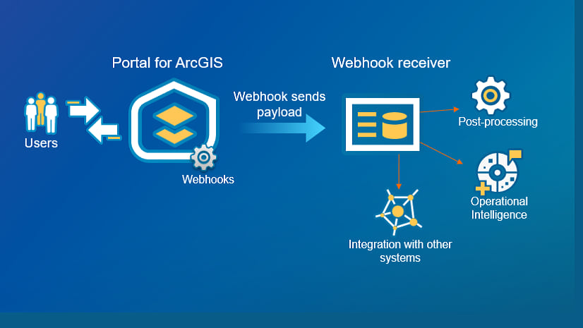
Track user logins using webhooks
Webhooks were introduced at 10.7, and in this release we have added the ability to trigger a webhook whenever users log in and out of your ArcGIS Enterprise portal.
This is helpful automation for administrators who want to monitor traffic to their portal and understand adoption and usage patterns.
Upload item experience
You can upload many different types of items directly to your ArcGIS Enterprise portal. At 10.7.1, we’ve increased the size limit of what you can upload to 200 GB (up from 1 GB).
When uploading items, you can also see the progress of your upload via a status bar. This is especially helpful when uploading those larger datasets.

Filter items shared through distributed collaboration
When sharing data using distributed collaboration (sharing to other ArcGIS Enterprise environments or ArcGIS Online), content management becomes a big consideration. At 10.7.1, administrators can now filter items by sending organization, making it easier to navigate shared content, and determine who sent what.
See an errant feature layer? Now you can identify who it belongs to.
Search content by location
This enhancement follows a 10.7.1 trend of making your data and information easily searchable and discoverable. At this release, your users can now search items by an extent in your Enterprise portal. This requires that an extent is set on the item.
It makes for a nice search experience using our favorite thing – location! Here is an example of the filter pane, where I could search all items that cover San Francisco:

More efficient downtime for ArcGIS Server machines
When multi-machine ArcGIS Server sites are in production, you occasionally need to take a machine out of commission for a bit, for example, when patching. During that time, service requests shouldn’t be passed to that machine, or your users will see those requests spin and time out.
At 10.7.1, a new system property in the ArcGIS Server Administrator Directory makes it easy to keep your site running smoothly while you’re working on a machine. The underMaintenance property in the Edit Machine operation is set to “false” by default. When you set it to “true” and save the change for any machine in your ArcGIS Server site, the machine will automatically start failing its regular health check and requests won’t be sent to the machine. It’ll still be sent administrative and publishing requests unless the machine has reached its machineSuspendThreshold for inactivity.
When you’re done performing maintenance on the machine, just set the underMaintenance property back to “false” and save the update. The machine will begin passing its health check (if everything else is healthy on the machine), and ArcGIS Web Adaptor will resume sending service requests for the machine to process.
Licensing notes
- If you’re upgrading from 10.6.1 or earlier to 10.7.1, you will need to relicense your software by generating new license files in My Esri.
- If you are upgrading from 10.7, you only need to relicense your ArcGIS Enterprise portal if you want to include ArcGIS QuickCapture or ArcGIS Maps for Office 365 in your license file.
A new licensing model for users was introduced at 10.7 called user types. To learn more, read through this blog introducing user types, as well as considerations when upgrading from older versions of the software.
Product support lifecycle
Recently, the product support lifecycle policy for ArcGIS Enterprise was updated. This blog from March is an essential read around this topic. 10.7 was the first short-term support release for ArcGIS Enterprise, while 10.7.1 is a long-term support release. If your organization likely will not upgrade again for a few years, consider moving to 10.7.1 for a longer support lifecycle.
Learn more
For a comprehensive look at everything that’s new and different in ArcGIS Enterprise 10.7.1, head over to the Enterprise documentation. The What’s New in ArcGIS Enterprise topic will get you started!


Article Discussion: