Indoor GIS and German Railways
The Esri International Infrastructure Management and GIS Conference (International IMGIS) is taking place in Frankfurt, Germany, from April 17-19 this year. The event will bring together professionals from multiple industries to explore new ideas in GIS, engage in various technical workshops, customer presentations, demonstrations, and more.
German Railways (Deutsche Bahn), who are exploring a vast range of use cases indoor GIS has to offer, are going to present their indoor GIS journey and plans for the near future.
Attendees of the International IMGIS Conference have the exclusive opportunity to get a sneak peek of what wayfinding at Frankfurt main station can look like.

Live Indoor Positioning Showcase Demo
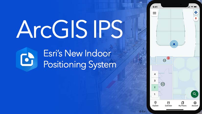
Within a 10-minute walking distance from Kap Europa convention center lies Frankfurt main station which is equipped with an indoor positioning system powered by ArcGIS IPS. The system uses small radio transmitters called Beacons that send out signals about their location. Mobile devices then pick up these signals and calculate their own relative position inside the building. 100 Beacons are currently mounted on walls throughout the area where wayfinding is enabled.
To create a digital indoor map of the station that visualizes all indoor data, spaces, and assets in a single, easily accessible place, BIM or CAD floor plan data needs to be processed within ArcGIS. For this project, this critical step was performed by Esri’s Indoor GIS specialty partner Atos.
Using the ArcGIS Indoors mobile app (iOS and Android) users can locate themselves on this digital map of the station. Their real-time position is visualized as a blue dot that serves as guidance inside the building. After GPS routes users to the station, IPS can take over to help them navigate indoors.
The current IPS setup is designed as a showcase for visitors of the International IMGIS conference and covers only part of the station between the platform on the ground floor and the city trains operating on the lower level. As ArcGIS IPS is floor-aware and helps the mobile device recognize which level it is currently on, transitions are seamless.
Conference visitors are invited to join us for a brief trip to the station and test the indoor positioning and navigation installation on site. There will be two excursions, to be announced again at the event.
ArcGIS IPS Showcase Demo at Frankfurt Main Station
Tuesday, April 18 | 8:30 AM CEST
Meeting point: DB Lounge at Frankfurt Main Station
Tuesday, April 18 | 1:30 PM CEST
Meeting point: IMGIS Conference Registration Desk
Be sure to join one of our excursions and try indoor navigation at the train station for yourself. Additionally, we recommend attending the following sessions at the conference that explore the wealth of indoor GIS use cases and how German Railways are applying them to enhance their operational efficiencies and customer satisfaction.
The Value of Digital Twins and Indoor GIS for Infrastructure Management
Monday, Apr 17 | 1:45 PM – 2:15 PM CEST
Indoor GIS: Facility Asset Mapping
Tuesday, Apr 18 | 10:15 AM – 11:15 AM CEST
Monitoring and Prediction of Transportation Asset Conditions
Deutsche Bahn: Indoor GIS to Streamline Maintenance Work- A Success Story in Work
Tuesday, Apr 18 | 4:15 PM – 5:15 PM CEST
For more information about indoor GIS, visit the following pages:

Commenting is not enabled for this article.