The March 2022 ArcGIS Online update introduces new features and key updates throughout the site. The same applies for ArcGIS Instant Apps, as we have released one app out of beta, introduced many updates and new features to our existing apps, further improved choosing and managing your apps, and addressed various bugs and enhancements to help stabilize and improve your experience across the site. See the highlights below.
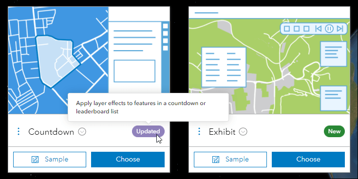
Exhibit out of beta
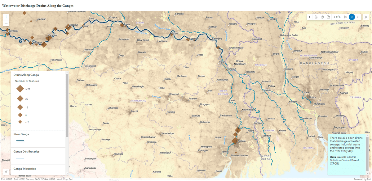
Design an interactive presentation of your map using the new Exhibit Instant App. Tell a linear story by choosing specific areas of your map to highlight using slides that offer interactivity options such as toggling layer visibility and choosing a unique basemap. With Exhibit releasing out of beta, we have included new functionality such as the ability to export slides to PDF, share a URL link directly to a particular slide, instantly jump to any slide in the app using the new slide list, the ability to use note colors from previously used slide notes, and more.
For details on all of the new options in this exciting app, please check out our Build an interactive map presentation with Exhibit blog. Also, please check out this live sample app using Exhibit: Course of the Ganges
Portfolio updates
Use the Portfolio Instant App to showcase different types of content all in one place by curating multiple resources related to a specific topic. New with this release are two additional layout options to choose from to customize your app experience. Use the new Tabbed layout to provide a minimalist style to the sections offered in the app, which shows each section’s title as a single line tab across the top of the app. Use the new Accordion layout to show larger amounts of section information at once, which collapses and expands each section in a side panel. Note that the existing Carousel layout will continue to be available and is the default layout in new apps.
Also new with Portfolio is the ability to add web pages as sections in the app using the URL option in the app configuration. This lets you include further resources about your app’s topic to be showcased with maps and apps. Furthermore, when links are contained in the description of a section, opt to open these directly in the main stage of the app. Find this configuration setting when editing a section, called Open links in app. Note that the provided URL must support embedding or the app cannot display it.
For more details about Portfolio, please check out our Display a Collection of Content with Portfolio blog. Also, please check out this live sample app using Portfolio: Health Insurance Coverage of Florida
Instant Apps landing page updates
The Instant Apps landing page offers a centralized place to browse, choose, create, and manage ArcGIS Instant Apps. This release we have added a new way to help you choose which Instant App to use based on your data, purpose, and workflow. On the Browse All tab, find the Suggestions button on the top right to expand the suggestions side panel. Answer a few questions to see filtered down app choices based on the answers you provide. It begins with a more broad question asking about the general goal for your app, and then narrows down based on your responses.
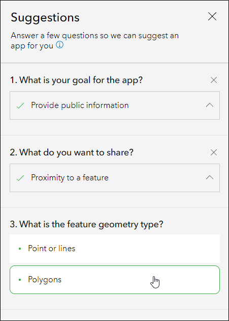
Suggestions are intended to help guide you to a more refined set of app choices. Try out this new feature and if you have any feedback about the question and answer choices, or about the experience as a whole, we would love to hear how we can improve. Provide any feedback you have on how we can help you choose the right Instant App by creating a post in our ArcGIS Instant Apps Esri Community page. We also recommend you check out our Introducing ArcGIS Instant Apps blog.
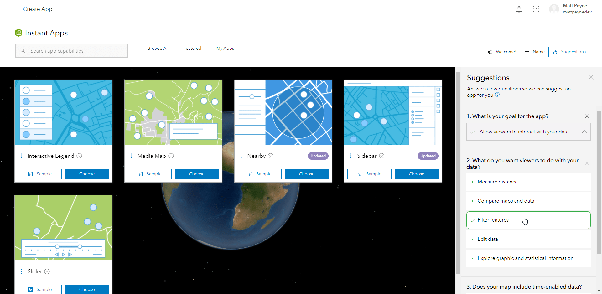
Also new in this release is the ability to open webmaps, web scenes, and groups that are used with your existing Instant Apps. On the My Apps tab, each one of your apps lists the map, scene, or group by name that is used for that particular app. Clicking on this hyperlinked name will launch the respective resource in it’s appropriate viewer. Webmaps will open in Map Viewer, web scenes will open in Scene Viewer, and groups will open to the group’s Overview page. For example, this makes it easy and direct to find out which map is being used in your app and then the ability to quickly edit it and make desired changes.
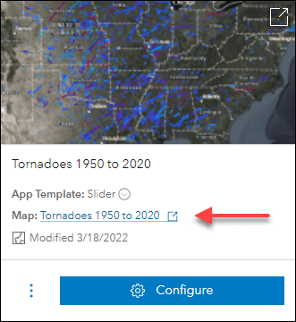
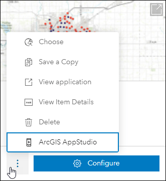
Another exciting update is the ability to create native applications with ArcGIS AppStudio directly from the My Apps tab. Currently, this workflow is supported with any Instant Apps you have created using Attachment Viewer, Nearby, and Zone Lookup. In My Apps, click on the ellipses dropdown for an app created using one of these three and choose ArcGIS AppStudio. You can confirm which Instant App template your app was created from by looking at the “App Template” part on the app card under the title. After you create the native application, you can access the item details page and find further instructions in the Description. For more information about customizing native applications with AppStudio, check out this Guided Tour for getting started, or take a look at these steps for Configuring a featured template.
To keep up to date with other new features we have added to Instant Apps, look for the purple Updated badge on app cards on the Browse All tab. These badges have hover tooltips with information about what feature is new for that app and these are updated with each release. Also, please check out our Introducing ArcGIS Instant Apps blog.
Countdown updates
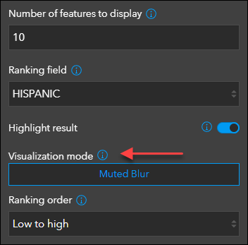
Present a list of locations in a map that is ranked by statistical values using the Countdown Instant App. New with this release is the ability to apply layer effects in your leaderboard list or countdown to help differentiate between active and non-active features. For example, apply the Drop Shadow + Blur visualization mode to emphasize features in the top 10 of a leaderboard with drop shadow, and deemphasize those outside of the top 10 with a blur. This setting can be found when editing both leaderboard lists and countdown lists in the app configuration using the Visualization mode setting.
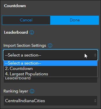
Also new is the ability to import list settings from an existing countdown or leaderboard while creating a new one. This is helpful when looking to duplicate a list or creating a good starting point when customizing a new list for the app. This can be done using the Import Section Settings option when editing the list.
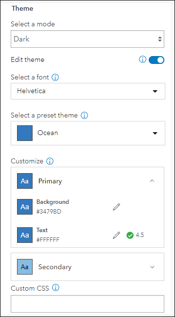
We have also added more control over customizing the theme of the app. On the Theme & Layout tab of the app configuration, enable Edit theme to access these new settings. Choose a font and a preset theme, and then choose to further customize the primary and secondary colors based on the preset theme.
For more details about everything new with Countdown, please check out our updated Three, Two, One: Updates to Countdown Instant App blog. Also, please check out this live sample app using Countdown: Texas Petroleum Facilities – Toxic Release Sites (2020)
Attachment Viewer updates
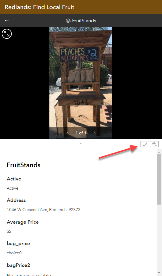
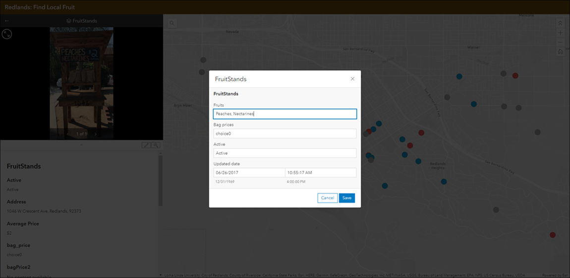
Display photos, videos, and PDF files stored as attachments alongside your map using the Attachment Viewer Instant App. New with this release we have added the ability for app viewers to update attribute information of attached images and videos while navigating through each feature. Enable the Attribute editing option in the configuration to include the editing button in the published app. Use this option for data reviewing workflows to assess and update information associated with feature attachments collected in the field.
Also new in Attachment Viewer is an updated sharing widget. We have improved and refreshed the sharing menu that includes social sharing options, the ability to generate a link, and the option to embed. The Copy Link option will preserve the current map view, layer visibility, and open popups. Use this option to share what you see in the app. To include this new sharing widget in your app, enable the Social sharing option in the configuration of your Attachment Viewer app.
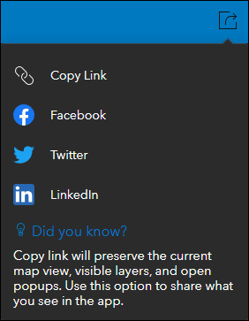
Chart Viewer updates
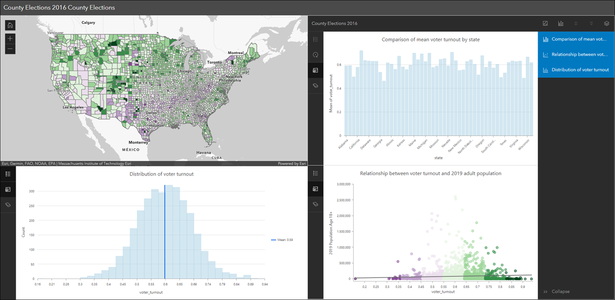
Chart Viewer leverages charts authored in Map Viewer to display data-based graphics alongside a map. Previously, two charts could be displayed at once but new with this release is the ability to display up to three charts alongside the map. Also new is the ability to expand either the chart(s) or the map to be viewed full screen in the app. For further details, please check out our Chart Viewer: a new Instant App blog.
Nearby and Zone Lookup updates
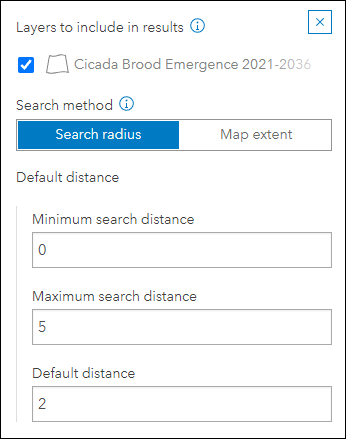
We have improved the configuration experience for choosing the type of search and lookup your app will perform when using Nearby and Zone Lookup. For Nearby, choose between using a search radius or the map extent to find close by features. The search radius offers a minimum and maximum search distance that can be customizable to the app user and will return features inside a circular buffer based on a location. The map extent option will return all features that are within the current map extent. The configuration now has a toggle on the Nearby tab that makes it easier to choose and configure this setting.
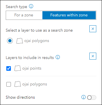
For Zone Lookup, choose between searching for a zone or searching for other features within a specific zone. For example, searching for a zone could be used to lookup what school district you are in based on a provided address location. And searching for other features within a zone could be used to find campgrounds contained inside of specific fire perimeter polygon. Similar to Nearby, we have included a toggle in the app configuration that makes it easier to choose and configure this setting.
In December we included the ability to export results to PDF from the app. New with this release we have included the option to also include the map. Enable the Export to PDF option in the configuration to include the option to export just results or the map and results to PDF.
Please check out this live sample app using Nearby: Sidewalk Cafés of New York City
Sidebar updates
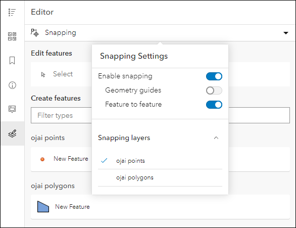
Sidebar offers a range of tools for exploring, understanding, and managing data. A panel containing these tools displays alongside the map and includes data editing, feature filtering, pop-up information, bookmarks, layer list, and more. We have added the ability to snap to features while performing editing workflows. Within the editor panel of the app, use the Snapping dropdown to configure settings such as types of snapping to perform and which layers will use it.
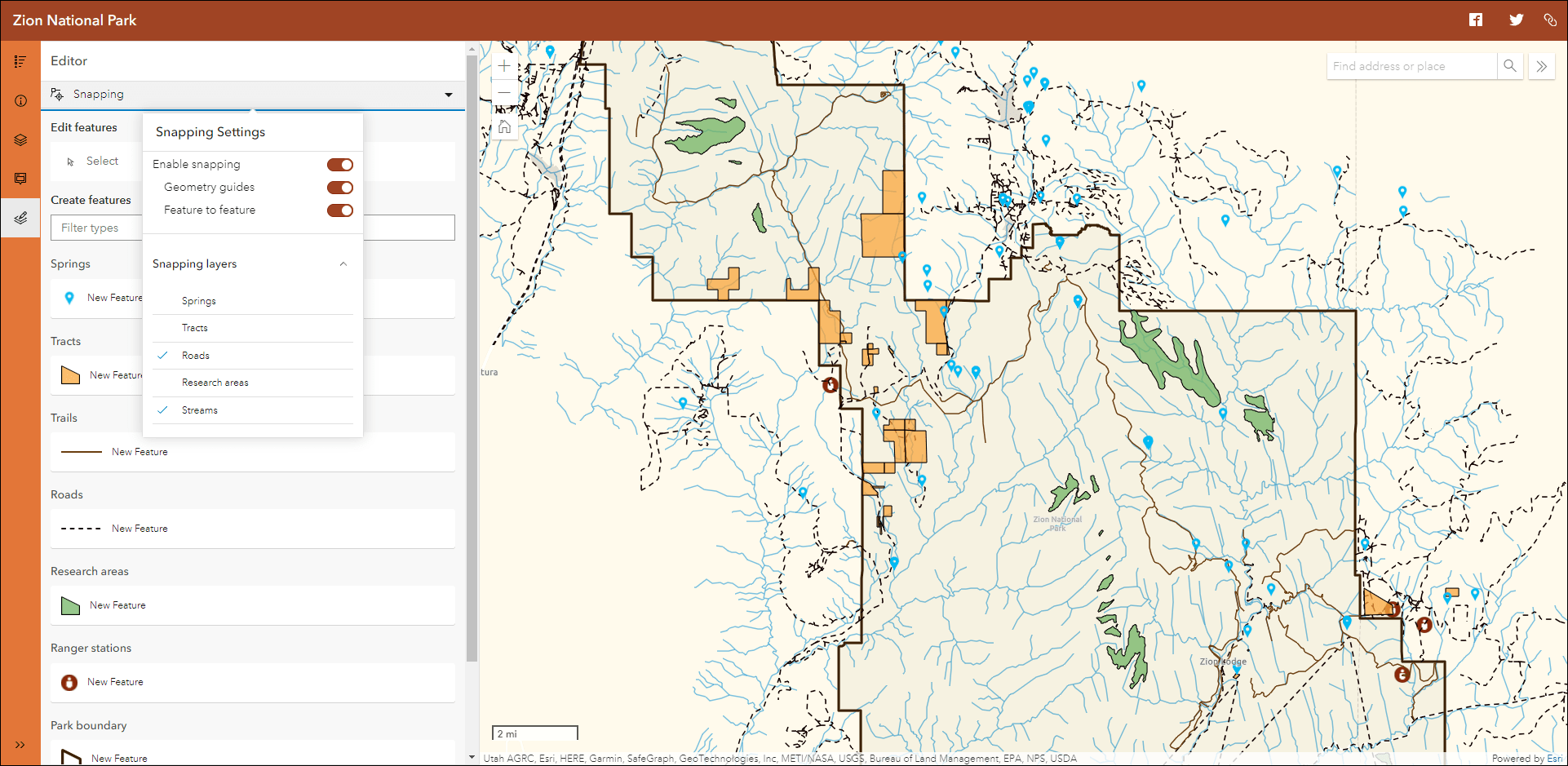
We have added new tools to Sidebar including a basemap gallery and the utility network trace tool. In the configuration, enable the Basemap gallery tool and then choose which group contains the basemaps you want to use in the app. You can use the default group or browse for a custom group of your own basemaps. Enable the Utility network trace tool when your map contains a utility network service and named trace configurations. For more information on this please check out our Trace a Utility Network with the ArcGIS API for JavaScript blog for more resources, information, and a walkthrough.
Also new in Sidebar is more control over customizing the theme of the app. On the Theme & Layout tab of the app configuration, enable Edit theme to access these new settings. Choose a font and a preset theme, and then choose to further customize the primary and secondary colors based on the preset theme.
For more information, please check out our detailed Sidebar blog.
Sharing apps from the app configuration
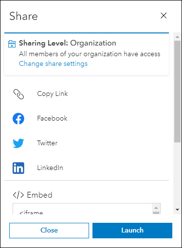
We have improved the sharing menu in the app configuration that includes social sharing options, the ability to generate a link, and option to embed. We have also included a new option to set the sharing level of your app in the same menu. For example, after publishing your new app choose to share it with your organization or the public instantly without needing to leave the app configuration as before. This new share menu displays automatically after you click Publish, or, you can access it in the left side menu bar by clicking Share.
Slider updates
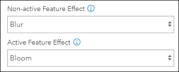
Animate through temporal or numeric data using the Slider Instant App. This release adds a few stylistic updates that give more customization to the app and data. We have added two new layer effect options, bloom and blur. Use layer effects to visually enhance your map layers in Slider based on active and non-active features. Find these new options on the Slider tab of the app configuration.
We have also added a collection of new preset themes that can be applied to the slider in the app. This gives more control and customization to the colorway used to theme the time or numeric slider. Use the Slider Theme setting on the Theme & Layout tab of the app configuration to choose from 10 different preset themes.
Feedback
We would love to hear any feedback you have on how we can improve your experience with ArcGIS Instant Apps. We would also love to hear your thoughts on any of the new features of this release. Please let us know by creating a post in one of our Esri Community pages so we can respond. For questions, use ArcGIS Instant Apps Questions, and for ideas, use ArcGIS Instant Apps Ideas.

Article Discussion: