Sharing your finished content with the public is an exciting moment. It’s an opportunity for your maps and apps to help other people. Imagine you need to create maps showcasing upcoming and current construction projects in your area and publish them to your company’s website. You’ve created beautiful maps, but what should you consider before you click the Share the items with everyone check box? The following four questions will help you implement best practices for sharing content with the public.
1. What do I want people to do with my map?
Edit data
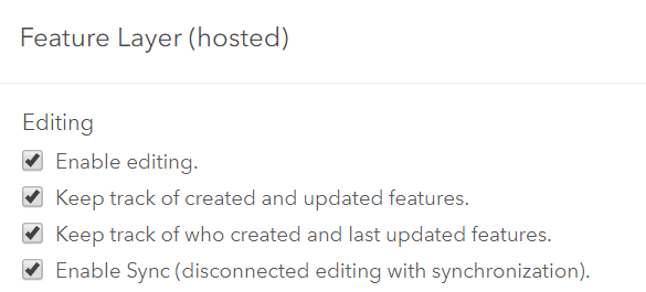
If you share feature layers to the public with editing capabilities enabled, anyone can edit your data. Users can add and delete features in your maps as well as update existing attributes. This is a necessary detail if, for example, you are creating polls or crowdsourcing apps. However, you can disable this setting for content you don’t want others to edit. Consider hosted feature layer views if you want to provide an editable view for certain groups and a noneditable view for others.
Save a copy
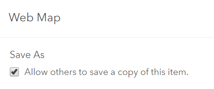
If your web map has the Allow others to save a copy of this item setting turned on, others can choose Save As and keep a copy of your map in their content. This means they can change pop-ups, symbology, and so on in their copies of your map and can even create web apps from this.
Interact with premium content
If you include premium or subscriber content in your app, consider how you want your users to interact with the content. As a best practice, provide full access to the premium layers using the configuration options in the ArcGIS Configurable apps. This blog post details how to use Living Atlas subscriber content in your public maps and apps. This way, users don’t need to sign in to see the premium content and your organization will be responsible for the costs of the premium content. Note: premium content costs 1 credit per 100 map requests (pan, zoom, identify), so a user would need to do a lot of map exploration to cost the organization a single credit.
If you don’t enable full access in the app, your app’s users will need to sign in with their ArcGIS Online credentials and will incur the premium content charges. You can pick whichever method works best for you.
2. How can I protect my publicly shared content?
Enable delete protection
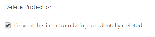
Prevent your items from being accidentally deleted by members of your organization by enabling delete protection. Members of the public never have access to delete your maps and apps, but mistakes can happen in an organization with many members who have content administration privileges or forgetful item owners. For this reason, we recommend enabling delete protection for all content shared publicly (layers, web maps, and apps). Deleting web maps or apps is a permanent action that cannot be undone.
Include Terms of Use
The item details page includes the Terms of Use detailing how the item can be used and by whom. For example, you may have a use constraint that requires others to display copyright information on any screen capture that includes your map.
3. Is my map accessible?
Complete the item details
The items details page of your data will help other users not only find your data but also understand how to use it and where to accredit it. Be sure to include a title, credits, a detailed summary and description of your data, easy to use tags, and an eye-catching thumbnail.
Consider sharing your maps in apps
Embedding your web map or sharing it as a link to the Map Viewer are convenient options. However, if you want to provide users with a more focused experience, you can choose from a variety of app templates and turn your map into an app.
4. Who in my organization can share publicly?
You chose the proper settings, enabled delete protection, and created a thorough item details page. You’re ready to share your map for others to use! To ensure that you have the right permissions in ArcGIS Online to share maps to the public, check your role and organizational settings.
Check your role
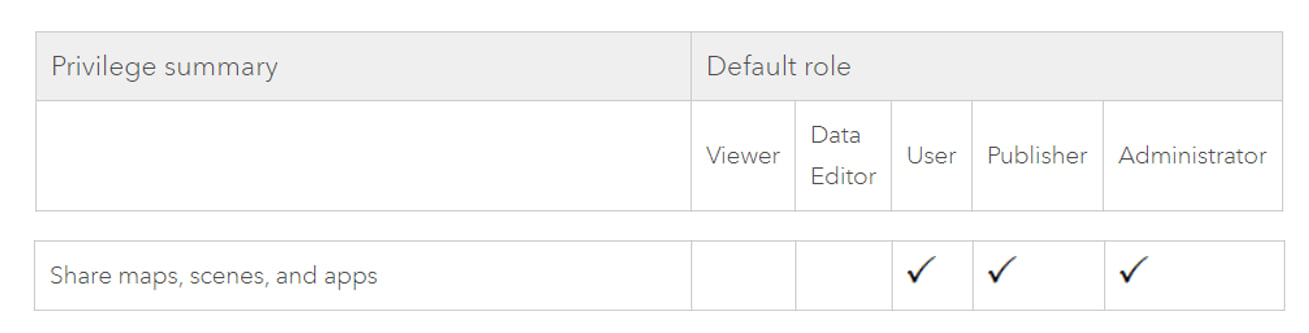
Only some roles have public sharing privileges. Check your role by signing into ArcGIS Online and clicking on your profile. If you are a User, Publisher, Administrator, or a custom role that includes sharing privileges, you have the privilege to share maps. See the chart below:
Organizational settings
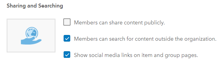
However, having a User role with sharing privileges does not guarantee you can share content publicly. Your organization can prohibit its members from sharing content publicly by unchecking the Members can share content publicly setting. If this is not checked, only administrators in the organization can share content publicly.
Administrators can set up a workflow in your organization in which you and others who are not administrators can nominate content that you want to share publicly for review. In the typical workflow, the administrator creates a group and invites the appropriate members to it. Members share content to this group, the administrator reviews it, and after approval, the administrator shares it publicly.
Now that you’ve gone through these questions and your maps are shared with the public, you can feel confident that your content is secure and reachable by your audience. You can continue learning about best practices for sharing content in our documentation.

Commenting is not enabled for this article.