ArcGIS Online has just been updated with the following new features and enhancements. This release includes updates and new capabilities for hosted web layers, configurable apps, apps for field and office, administration, accounts, and much more. For additional details see the What’s new help topic.
View all related posts for this release.
Map viewer
The map viewer is the built-in app that enables you to view and author maps, navigate, see map details, edit, perform analysis, and more. Updates for this release include the following.
Introducing Arcade
Arcade is a new lightweight expression language introduced at this release. You can author, edit, or apply custom expressions written in Arcade when styling and labeling feature layers in the map viewer. For example, an Arcade expression might be created to find the average traffic counts over a five-year period at traffic monitoring locations. Counts can then be represented using a graduated-size symbol on the map.

See the Arcade help for more information.
Other map viewer enhancements
Attribute tables
Additional capabilities have been added to feature layer attribute tables. Now you can edit or delete attributes directly in the table, and view and edit related records, photos, and files.
Time
When you save a web map with a time-enabled layer, you can start the time animation from the time position saved with the map, instead of at the beginning of the time span of the layer.
Dynamic layer labeling
The map viewer now supports labeling in ArcGIS Server map image layers that support dynamic layers.
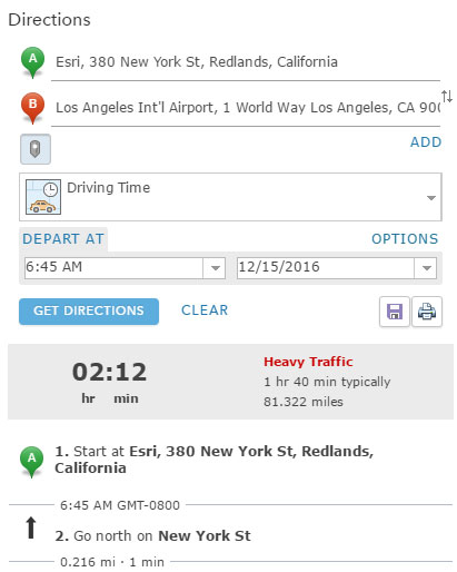
Route start times
You can now generate routes using a specified start time, and obtain directions based on your chosen time. The directions also include the arrival and departure time at stops, and typical traffic conditions.
WMTS enhancements
When adding a WMTS layer to a map, if the layer does not support a coordinate system and tiling scheme that aligns with the current map, you now have the option of adding the layer as a basemap and choosing a tiling scheme.
Scene Viewer
The scene viewer is the built-in app for creating and interacting with 3D scenes. Updates for this release are listed below.
Point cloud data can now be visualized on the web using a new layer type, point cloud scene layers, optimized for fast display of many kinds of 3D sensor data, including LiDAR. You can display large amounts of surveyed point cloud data of buildings and the surrounding terrain, including trees, bridges, and parks.
Vector tile layers can now be used in 3D, offering much faster loading. They can be brought into your scenes as operational layers or as basemaps.
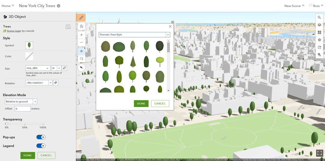
A new gallery has been added with 2D marker and 3D object symbols enabling you to create captivating scenes. The symbols include street furniture, transportation, trees, and thematic icons.
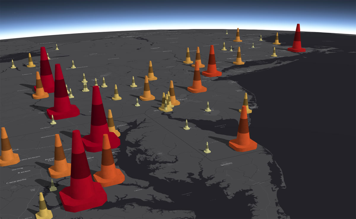
New drawing styles use attributes to drive the visualization of point layers. For instance, if you have population as a numeric attribute, you can easily visualize your data with proportional symbols for color and size based on the population value. Additionally, with the new style slider in the scene viewer you can adjust the size and color interactively.
The camera animation for point-to-point flights has been enhanced to provide a smoother user experience.
Analysis
ArcGIS Online offers hosted analysis tools that you can apply to your data (depending on your privileges) and are available via the Analysis button.
A new Join Features tool allows you to transfer attributes from one layer or table to another based on spatial or attribute relationships.

Examples of how this tool can be applied are:
- Append common boundary or demographic information to your incident data.
- Identify the closest facilities to a known location.
- Determine the number of residences that fall within flood zones.
- Identify common habitats for different wildlife species.
A new Find Outliers tool creates a map showing any statistically significant clusters and spatial outliers present in your data.

Use this tool to identify features that have values that are significantly different from their neighbors. Ask questions such as the following:
- Where are anomalous spending patterns?
- Where are the sharpest boundaries between affluence and poverty in the study area?
- Do we have stores that are struggling with low sales despite being surrounded by high performing stores?
- Are there counties in the United States with unusually low life expectancy compared to their neighbors?
Plan Routes, Find Nearest, and Connect Origins to Destinations now have the ability to save the results as route layers. This enables you to share the individual routes with other members in your organization, or further modify the routes using the Directions button in the map viewer.
Hosted web layers
When you publish data using ArcGIS Online, the hosting is provisioned for you. Web, desktop, and mobile apps can access your ArcGIS Online hosted layers from anywhere on the Internet, with you controlling access and sharing. Hosted web layers can be published directly from your desktop without installing your own server, leveraging ArcGIS Online’s publishing capabilities. The following are new features and capabilities for this release.
Multiple views on hosted feature layers
You can now create multiple views of hosted feature layers. This allows you to publish your data once, then create tailored views for different audiences. Views reference the same underlying data (the source, or primary data) but can offer different capabilities, cartography, and filtering.
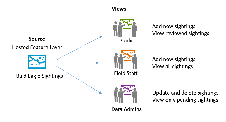
For example, you can share your hosted feature layer for public view-only access while allowing certain members of your organization to edit the data. Since they share the same source, as edits are made view-only users will see changes. Or, you can publish multiple renderings of the same data highlighting different attributes.
Other hosted web layer enhancements
- You can publish hosted WFS layers from an existing hosted feature layer. Additionally, you can now access hosted tile layers as OGC Web Tile Map Service (WMTS) layers.
- You can now publish hosted scene layers from hosted feature layers (beta). During the beta period, organizations will not consume credits when publishing or storing hosted scene layers from hosted feature layers.
- You are now prevented from deleting source data from hosted web layers unless you first delete the hosted web layer.
- Storage reports are now available for vector tiles and scenes. In addition, feature storage reports include a list of the feature layers that use storage credits.
Configurable Apps
Configurable apps provide an easy and fast way to go from a web map to an application, with no coding required. The following is a list of updates and enhancements for this release.
The configuration pane in several of the configurable apps has been redesigned. The configurable options now appear as tabs across the top, and the pane includes your map, scene, or group.
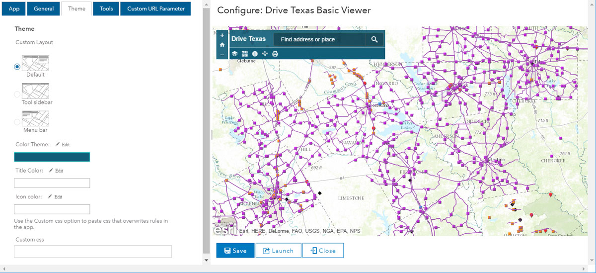
New themes have been added to Basic Viewer, Elevation Profile, and Map Tools supporting different layouts.
Crowdsource Polling now supports using a URL parameter to open the app to a specific feature, as well as sorting items by the values in any field. Comments on features can now include attachments such as images and documents.
New configuration parameters have been added to Crowdsource Reporter providing more control over the text and appearance of the app. Configuration parameters have also been added to restrict where reports can be submitted, and to allow reporters to update and delete their submissions. Comments on reports can now include attachments such as images and documents.
Finder and Find, Edit, Filter are now in mature support.
Story Maps
Story Maps let you combine authoritative maps with narrative text, images, and multimedia content, making it easy to harness the power of maps and geography to tell your story. The following are enhancements for this release.
Story Map Journal and Story Map Series now support dragging and dropping local images from your computer directly into your stories as you author them. This is the recommended and easiest way to add images.
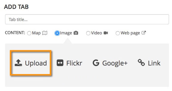
Uploaded images are automatically optimized to give the best performance and are stored within your story (not as unique items). Sharing is governed by your story, so you don’t need to have publicly stored images when your story is only intended for internal use. You can also upload the image used for your logo in the story header.
Story Map Journal text sizes, styles, and spacing have been updated to improve readability and the appearance of your stories. New and existing stories will reflect these changes.
Story Map Cascade (beta) builder now reports issues with your story such as images and maps that are missing or not shared properly. Errors and warnings appear inline in your story, along with suggested fixes.
Story Map Shortlist (beta) has quality improvements, better integration with My Stories, and better looking thumbnails.
Web AppBuilder for ArcGIS
Web AppBuilder provides a way to easily create HTML/JavaScript apps that run on any device, using a gallery of ready-to-use-widgets. You can customize the look of your apps with configurable themes, and can host your apps online or on your own server. With this release, the following widgets have been added or enhanced.
- A new Extent Navigate widget is available for navigating the map to its previous or next extent.
- Add Data now supports adding layers from groups and local files including shapefiles, CSV, GPX, and GeoJSON.
- Basemap Gallery has a new option to synchronize with the basemap gallery setting of the organization at runtime, and allows you to import basemaps from a group.
- When running a query against a related table, all the related features are now highlighted on the map and listed in the Query panel. You can also change the symbol at run time to highlight the query result differently on the map.
- Filter and Query now support the ability to filter values by all applicable expressions in addition to the previous expressions.
- Directions now supports predefined start and end stops and displays the default travel modes at run time when the travel mode URL is not specifically configured.
- Smart Editor now hides the cache layer from the app so it no longer displays on the Layer List and Legend widgets.
- Near Me and District Lookup add new options for advanced search and using a pushpin button to set the location.
- Symbol Picker now supports custom images as point symbols.
- You can now add markers to the features and locations you are interested in or remove markers from them.
For more information, see the Web AppBuilder for ArcGIS help.
Apps for the field
ArcGIS apps for the field help you use the power of location to improve coordination and achieve operational efficiency in field workforce activities. Field apps have had numerous enhancements since the previous ArcGIS Online update. These enhancements include the following:
Collector for ArcGIS 10.4, with support for high-accuracy GPS receivers, is now available on iOS, Windows, and Android devices. For more information, see the Collector for ArcGIS help.
Explorer for ArcGIS 10.2.10 was released on iOS in December, and included fixes. For more information, see the Explorer for ArcGIS help.
Navigator for ArcGIS is now available on Android devices. For more information, see the Navigator for ArcGIS help.
Operations Dashboard for ArcGIS 10.3.4 includes updates for both browser and Windows apps. For browsers, support for two new languages, Indonesian and Bosnian, has been added. For more information, see the Operations Dashboard for ArcGIS help.
Survey123 for ArcGIS 1.9 released in November. With this release, you can now share your surveys publicly, allowing field workers to capture data without signing in to an organization. Authoring smart forms from your web browser includes new types of input options, such as email. Minor enhancements have been added to the Survey123 web and native apps. For more information, see the Survey123 for ArcGIS help.
Workforce for ArcGIS, updated in October, included an improved search, the ability for dispatchers to create multiple assignments, support for users from other organizations, and new languages. For more information, see the Workforce for ArcGIS help.
Apps for the office
Apps for the office have made numerous enhancements since the previous ArcGIS Online update, including the following:
Esri Maps for IBM Cognos 6.1.1 offers significant updates and enhancements, including new interactive behaviors to update the map, automatic clustering of point layers, and the ability to create and use labels. The user experience for several other features has been improved. Esri Maps for IBM Cognos 6.1.1 was released in September 2016. For more information, see the Esri Maps for IBM Cognos help.
Esri Maps for MicroStrategy 3.0 features a streamlined app that contains many user experience improvements, including the ability to customize map tools and settings, apply predefined or custom themes to a map, and create and use labels. For more information, see the Esri Maps for MicroStrategy help.
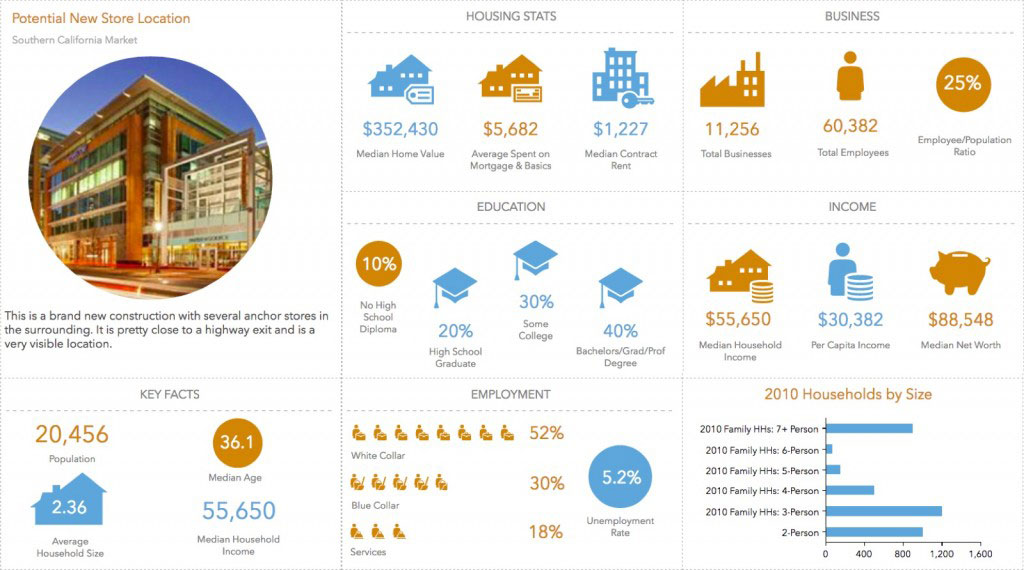
Esri Business Analyst 5.4 enables you to create visually appealing infographics in a few clicks to quickly gain demographic insights for any location.
Other features and enhancements include:
- Business Analyst now works seamlessly with both ArcGIS Online and ArcGIS Enterprise. For Enterprise users, this means you can use Business Analyst mapping, analysis, and reporting using your own proprietary and sensitive data managed within your own infrastructure.
- Perform suitability analysis to rank locations based on multiple weighted criteria, and determine locations most suitable for your business.
- Use your own data with Esri Demographics, and perform more customized market analysis.
- Manage and share your content more efficiently using a project based content management structure that helps you store, organize, and share your content.
- Leverage the new daytime population data for the U.S. and a number of international data updates, including demographics for Canada, China, Russia and several European countries.
For more information, see the Esri Business Analyst Web App help.
AppStudio for ArcGIS
AppStudio for ArcGIS is a tool that converts your maps into native mobile apps for Mac, iOS, Android, Windows, and Linux.
- AppStudio now supports virtual devices using Android emulators and iOS simulators.
- A new advanced configuration tool guides you through configuring a Qt kit to work with AppStudio.
- Enterprise logins are now supported.
- AppStudio Player has been enhanced with improvements to the app gallery, camera support, and more.
- Map Tour template now supports sorting images by distance and name, sending email feedback through your app, and playing story map videos within your app.
- Map Viewer template includes additional information on the map such as a layer list, map units, scale, and location accuracy.
- Quick Report now includes an option to show a custom message after submitting the report, the ability to add multiple photos, offline support for creating and editing reports, and the ability to display maps on the location page.
For more information, see the AppStudio for ArcGIS help.
ArcGIS content
- Vector basemaps are no longer in beta and are available to use in production web maps and apps. Vector basemaps have been updated in several areas and known limitations have been addressed. These basemaps will be updated at regular intervals.
- The World Topographic basemap has been updated to include detailed map data for China with English labels, referencing authoritative map services built and maintained by the National Geomatics Center of China.
- The World Imagery basemap has been updated with new DigitalGlobe imagery for several countries, including detailed imagery for many metropolitan areas. More imagery updates will be deployed over the coming months.
- Detailed boundary layers for several dozen more countries have been added to the Living Atlas and made available for display and analysis through the map viewer and ArcGIS apps.
- Demographic maps for the United States have been updated for selected data, including Retail Marketplace and Shopping Centers. A new variable for daytime population is now available for mapping and analysis.
- Demographic maps for the following countries have been updated with the latest demographic data: Belgium, Canada, China, Denmark, Finland, France, Germany, Italy, Netherlands, Norway, Poland, Russia, Spain, Sweden, Switzerland, and United Kingdom.
For the latest, see posts appearing in the ArcGIS Online blog.
Organization administration
Administrators can leverage two levels of membership when assigning roles and privileges to members. Levels allow organizations to control the scope of privileges that can be assigned to members through roles.
Level 1 members can view content shared with them, but cannot create, own, or share content. Level 2 members can view, create, and share content, depending on the privileges assigned by the organization administrator. See Levels, roles, and privileges for more information.
Administrators can now change the short name of the organization through the general settings tab. This is a permanent change that cannot be undone. Some URLs will need to be manually updated, for example, apps created with Web AppBuilder for ArcGIS that are hosted in the organization.
Organizations have an additional security setting to allow portal access. By configuring a list of redirect URIs, the organization gives members who use enterprise logins access to secured content in web apps hosted on other portals.
Accounts
Organizations can now configure social logins, which allows members to join the organization using their Facebook or Google credentials. Once members have created their account, they can sign in to the organization and their apps using their social login. In addition, administrators can enable Esri access on social logins so members have access to Esri web resources such as GeoNet.
For more information
For more information about this release, see the Whats New help topic or ArcGIS Blog posts specific to this release.


Article Discussion: