During the last three years, we’ve seen explosive growth of interest in 3D GIS. From scientific analysis to engineering design to agriculture, customers are solving real world problems with location-based, 3D visualization and analysis. 3D is a critical component of this information because it offers the ability to more accurately capture, inspect, and model the real world than has ever been possible before.
Esri software development teams have been expanding and striving to provide tools for customers to use 3D in both traditional and new workflows and GIS experiences. I’ve been glad to see the number of voices talking about the great work we are doing grow as well.
- You can read blogs about 3D enhancements in ArcGIS Online, the new elevation surface experience in ArcGIS Pro, and 3D updates in ArcGIS Runtime.
- Our teams publish story maps to show you what’s new in product and tech areas, such as the Scene Viewer.
- You can also see lots of great content on other social media such as Twitter and LinkedIn.
- We have dozens of sessions, talks, and ad hoc presentations covering 3D at the UC this year.
So that the highlights don’t get lost in the details, I’ve listed some of the top things to pay attention to here. These are some of the biggest topics that customers have been asking us about and it’s great to be able to speak with users about so many of these diverse 3D-related efforts. Some of these items include topics that have been building over the last few years, but there is a ton new to talk about at this year’s UC.
What if you don’t see your favorite topic here? Please stop by the 3D GIS Showcase in the Expo Hall where our experts can help you find what you need now or (even better) can listen to what you will need in the future.
BIM and AEC
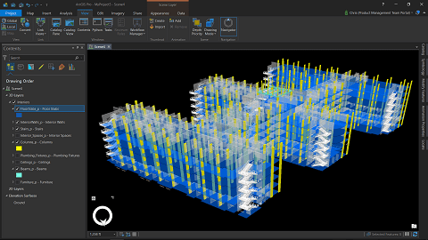
As governments and corporations adopt Building Information Management (BIM) globally to drive more efficiency in the trillions of USD of investment required to propel us sustainably into the 21st century, asset owners and construction and design consultants have realized that location is an essential component of successful BIM projects.
Esri has jumped into the BIM market with both feet, educating partners and customers, developing software to support better integration of design and location, and launching an industry changing alliance with Autodesk. This years’s UC caps about two and a half years of effort to get the BIM story rolling at UC and I couldn’t be happier that we’re where we are.
- The new Engineering Summit kicks things off today with talks from industry experts from Esri, Autodesk, and customers
- UC Plenary – Don’t miss a fantastic story that came together because of a collaboration between Autodesk, Esri, and a major AEC joint-customer
- Autodesk has a large presence at this year’s UC – Please stop by their booth, thank them for helping to sponsor the show, and tell them that you want even more collaboration
- Look for ArcGIS Pro’s new capability to read Revit files, Autodesk InfraWorks’ new Autodesk Connector for ArcGIS, demos integrating BIM 360 and ArcGIS Online and more
Interactive tools
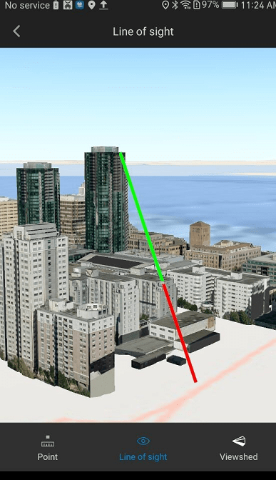
For years, every day people have been able to touch things, see shadows, and change them in 3D games. It’s natural that GIS users should expect to do the same with the 3D data that represents their real world environments. Since the 2017 UC, we’ve seen a rollout of interactive analytical tools across the ArcGIS platform. These include inter-visibility tools in ArcGIS Pro and Esri CityEngine, 3D measurement tools in the ArcGIS API for JavaScript.
- Visit the ArcGIS Pro island and the 3D Showcase in the UC Expo hall to see the intervisibility tools at work
- Nathan Shephard will demo Pro’s new capabilities in a regular UC session
- Eric Wittner CityEngine session will discuss urban planning-focused capabilities, including interactive tools
- Find the ArcGIS Earth team in the 3D Showcase and ask for a demo of new interactive tools that we’ll be releasing later this summer
Mobile
Many of our customers are exploring mobile-first or mobile-only work environments. While the high end data and analysis authors in many fields will likely stay on desktop computers for years to come, many more software users are transitioning to mobile-format experiences. That’s as true for 3D GIS experiences as it is for any other part of our user workflow.
- Checkout the new capability to use the Scene Viewer and the ArcGIS API for JavaScript 3D capability on mobile devices at the 3D Showcase and in the Developer Showcase
- Find the ArcGIS Earth team and ask about the alpha release of ArcGIS Earth for Android devices which we are planning to ship in the next few weeks
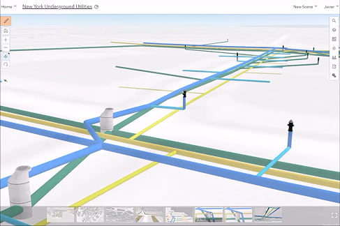
Underground capabilities
Two years ago, I was cornered after a talk on 3D by 5 or 6 users who complained that when it came to underground, we had nothing. We’re trying hard to change that and this year you’ll be able to take a look at:
- The ability to navigate underground in the Scene Viewer in global scenes and the ability to manipulate the transparency of the ground surface both in the UI and in the API
- A new experience for manipulating surfaces in ArcGIS Pro
- The new slice exploratory tool in ArcGIS Pro that enables the ability to inspect complex subsurface data
- The Utility Network which has been built to accommodate above and below-ground 3D utility information
- If you can find me, ask me about our R&D with voxels…
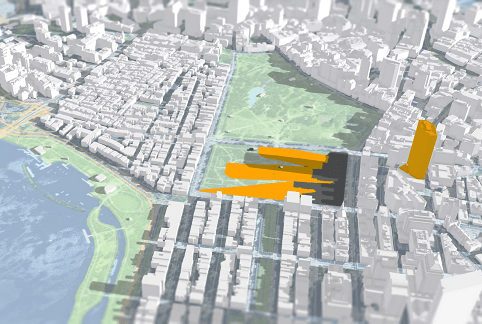
Urban Planning
We are increasing our focus on Urban Planning solutions and we have several initiatives that we’d love to speak with you about to help us guide where we’re going in the future.
- CityEngine has made tremendous strides to be better oriented as a tool for Urban Designers. Great work from partners, such as Houseal Levigne Associates and Garsdale Design showcases how far CityEngine has come.
- The 3D team will be eager to show you some of the upcoming capabilities planned for ArcGIS Urban. Stop by the 3D Showcase and ask about what we’re planning.
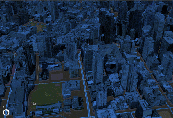
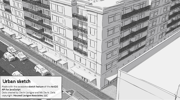
AR, VR and other new visualization capabilities
The experience of GIS is fundamentally changing as we are seeing more demand for Augmented Reality, Virtual Reality, game engine dynamics, and higher visual quality. Work from Esri R&D and many of our partners is helping to push real world content from GIS into experiences that allow users to interact with their data in whole new ways. I expect to see much more on this over the next few years.
- Ask about the AR capabilties in the ArcGIS Runtime SDKs at the Developer Showcase
- Meet up with the ArcGIS Urban team and the CityEngine team at the 3D Showcase and ask about how we’re exploring VR for Urban Planning workflows
- Check out our partners who are already delivering products for AR to our users, such as Argis Solutions and Meemim Inc.
- Ask the 3D team at the Showcase about the new edge rendering capability in ArcGIS Pro and the ArcGIS API for JavaScript, including the great new sketchy edge capability
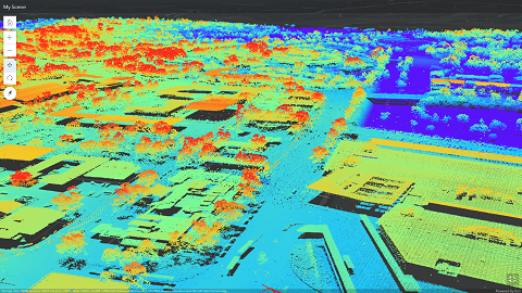
I3S and 3D Content
Last year, we were happy to have the Indexed 3D Scene Layer (I3S) specification adopted by the Open Geospatial Consortium (OGC) as a Community Standard. We’ve seen numerous partners and others in the community start to produce I3S content that is directly usable in ArcGIS products. We’re also seeing a ton of other 3D content, such as point clouds, IoT, and reality capture data being integrated into GIS for whole new experiences allowing us to explore our world.
- Check out our many content provider partners who will be here including Vricon, Nearmap, Orbit, and many others. Ask them how they can help you acquire 3D content for use in your GIS workflows.
- Visit the 3D Showcase and ask about I3S and how it changes the way 3D is shared and distributed across ArcGIS
- While you’re at the 3D Showcase, ask about new capability to go directly from formats such as LAZ and zLAS to I3S to allow you to use your point cloud data in new workflows
- Ask the Living Atlas team about the new AIRBUS content that allows us to deliver the highest res 3D ground elevation data set that is available from any GIS vendor today for use in everyday
- Attend the I3S related talks and ask at the 3D Showcase about the new capability to edit feature-based scene layers
See you at the UC!
I hope to see you at the UC this year and I’d love to hear your feedback. It’s another exciting year for progress in 3D with ArcGIS.
I’d like to thank our customers, including the University of Kentucky, for continuing to provide demo content for us to be able to test, develop, and demo the new capabilities that our users need.


Commenting is not enabled for this article.