Have you ever wanted to geocode a single large file in ArcGIS Pro through the ArcGIS World Geocoding Service? With a recent update to the service, the geocoding tools in ArcGIS Pro 3.5, and newer, now have access to the Batch Geocoding service. When the Geocode Addresses guided UI and Batch Geocode geoprocessing tool are opened, they will check which geocode services are present. These tools are able to connect to the ArcGIS World Geocoding service to see the available options from that service. The response will show both the ArcGIS World Geocoding Service and the ArcGIS World Geocoding Service (Batch).
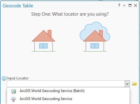
Geocode Table
In the Geocode Table pane the drop-down list for the Input Locator parameter will now include the Batch Geocoding service. While this new service is present, the file being geocoded must contain 100,000 records or more for the batch geocoding service to displayed in the drop-down list for Geocode Table tool.
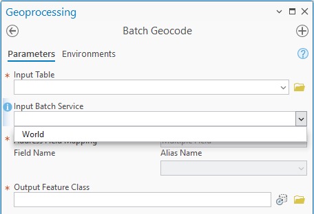
Batch Geocode
The drop-down list for the Input Batch Service parameter will now include World. While this new service is present, the file being geocoded must contain 100,000 records OR more to be submitted to the service. Smaller files will not be accepted.
Learn More About Geocoding in ArcGIS Pro
Ready to explore the geocoding capabilities of ArcGIS Pro? Click here for more information.
Learn More About the ArcGIS Geocoding Service
Ready to explore the enhanced capabilities of the ArcGIS Geocoding service? Click here for more information.
Additional Resources
For a detailed overview of the improvements in this update, visit our What’s New page.
If you have any questions or need software support, don’t hesitate to contact our dedicated support team. For further details on our data coverage, check out the ArcGIS Geocoding service Data Coverage page.






Article Discussion: