
With the most recent updates to the ArcGIS Geocoding service, we’re excited to offer new capabilities and expand the content available in the service output.
Quality improvements
- Address matching in Austria, Belgium, Colombia, India, Italy, Mexico, Norway, Poland, Portugal, Puerto Rico, Rwanda, Svalbard, and Switzerland is improved through increases in point address coverage.
- Performance improvements for
findandAddress Candidates geocoderequests are now faster.Addresses - Countries with match narrative support now include Hong Kong, Malaysia, Philippines, Romania, and the Slovak Republic.
API and service output changes
- A new API parameter, interpolatePointAddress, is now supported for
findandAddress Candidates geocoderequests. This parameter allows you to receive a more precise location when a rooftop address doesn’t exist.Addresses - interpolatePointAddress = false is the default value
- The location is more precise because it uses linear interpolation between nearby PointAddress records.
- Along with the new parameter, there is a new value for the
Addrfield – PointAddressInt._type - This is the
Addrvalue returned when PointAddress interpolation is used to generate a candidate._type
- Along with the new parameter, there is a new value for the
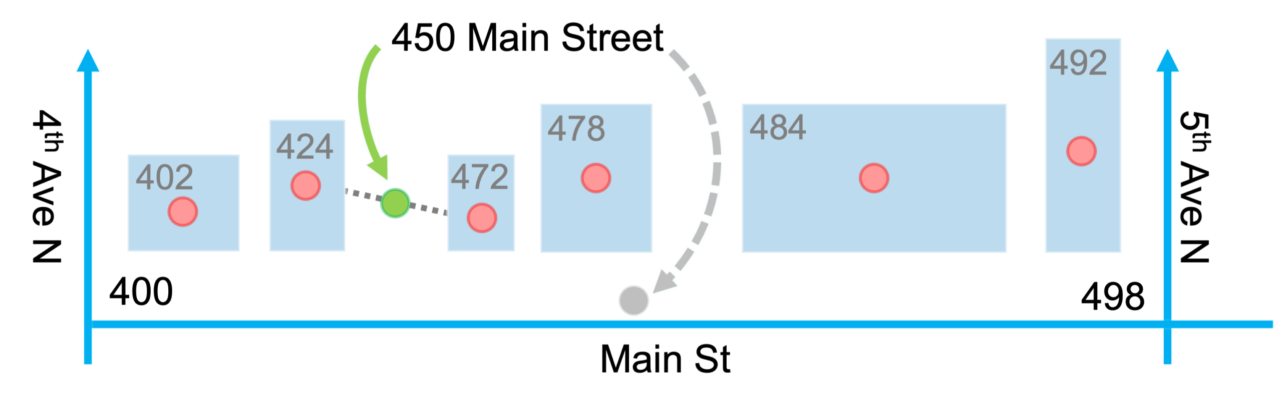
- In the image below, you can see the difference between Addr_type = StreetAddress and Addr_type = PointAddressInt
- The gray dashed line and dot indicates
Addr_type = StreetAddress - The green solid line and dot indicates
Addr_type = PointAddressInt
- The gray dashed line and dot indicates
- There is also a new
codevalue for the MatchNarrative output field –b- The
bvalue indicates that PointAddress interpolation was used to match theHousecomponent.Number
- The
See it in action
To make the difference tangible, we built a small interactive sample app around a real case: Cruquiusweg 134, Amsterdam, geocoded twice with findAddressCandidates, changing only interpolatePointAddress.
With interpolatePointAddress=false, house number 134 has no rooftop record, so nothing matches it: the geocoder falls back to the street itself (Addr_type: StreetName), returning a point near the middle of the street, and the MatchNarrative marks 134 as Unidentified
With interpolatePointAddress=true, the service looks for available point addresses on that side of the street it does have real PointAddress records for — 130 and 142 — and places 134 by interpolating linearly between them. The result is Addr_type: PointAddressInt with score 100, AddRange 130-142, and a MatchNarrative where HouseNumber now carries the new b code — some 165 m from where the same address was returned without the parameter.
The app draws that whole range on the map — 130 and 142 as the known rooftop anchors, 132 to 140 as the evenly spaced interpolated points between them — so you can see exactly what the parameter is doing. Switch between the false result, the true result or both, and click any candidate to inspect its attributes and full MatchNarrative. It runs entirely on saved service responses, so what you see is exactly what the service returned.
Learn More About the ArcGIS Geocoding Service
Ready to explore the enhanced capabilities of the ArcGIS Geocoding service? Click here for more information.
Additional Resources
For a detailed overview of the improvements in this update, visit our What’s New page.
If you have any questions or need software support, don’t hesitate to contact our dedicated support team. For further details on our data coverage, check out the ArcGIS Geocoding service Data Coverage page.






Article Discussion: