Organizations everywhere are leveraging address validation, verification, and standardization processes to improve the accuracy of their addresses. These processes can vary based on the software being used. At Esri the geocoding capability is about finding places such as addresses, street names, postal codes, cities and more. For years Esri has called geocoding the process of finding places, but we understand there are a variety of terms that intersect with geocoding. In this blog we will discuss how terminology for address processes and address IDs apply to the ArcGIS Geocoding capability.
Address Validation and Address Verification
Address validation and verification are really one and the same. Address verification (validation) is about comparing an observed address to a known reference address database. The reference address may be in the form of a list of known addresses, or it could be in the form of a geographic file of curated addresses such as parcel boundaries, rooftop or subaddresses (units or apartment) points.
Esri’s geocoding capability takes an observed address and checks it against an authoritative set of reference addresses. The reference addresses are expected to be a comprehensive list of all types of addresses including addresses where deliveries are made, where people live and work and other addresses where someone may need to perform a local service such as an insurance estimate or a survey. The goal in geocoding is to find all types of places and locate them precisely.
Getting back to address validation, a geocoder can be an address validator (verifier), especially if the reference data used in the geocoder is a comprehensive list of known addresses. In some instances, organizations will ask about validation or verification in a more focused way. For instance, they may want to ask if an observed address can receive postal deliveries. This type of address verification would be performed on a subset of a comprehensive list of addresses as postal addresses are expected to exist within a comprehensive list.
Address Standardization
Another common term related to geocoding is address standardization. Address standardization is about taking a complete address and breaking it down into its components. For example, a USA address may have a house number, a street name, a postal code, city name and state. The street name could be further parsed into components such as the street direction, base street name and street type. It may be useful to have address components standardized so you can query addresses based on those existing, for example in a postal code.
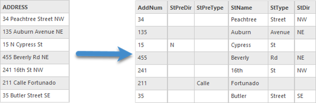
Address data that is standardized can be easier to work with and is a key part of Esri’s geocoding system. All reference addresses are standardized. When you match an observed address against a reference address, the fully standardized reference address is returned in the result. So, for any unstandardized input address that is validated and verified, you will receive a fully standardized reference address in the geocoding output. Addresses that geocode against Esri’s geocoding system at the subaddress and Point Address level are validated against comprehensive authoritative data, and the output includes a standardized form of the address for effective organization or address components and querying.
Address Normalization
Another common term used in geocoding is address normalization. Normalization is about taking different terms like STREET, STR and ST and converting them to a common representation. STR and ST are abbreviations for Street. Converting them all to the same value can simplify how data is represented and can make querying data more straight forward.
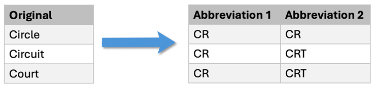
However, address normalization does have some challenges. By changing the original authoritative reference data it’s possible to introduce ambiguity into an address. Consider the street types of CIRCLE, CIRCUIT and COURT. It’s possible to abbreviate all these streets to CR, but only CIRCUIT and COURT would abbreviate to CRT.
Another example of normalization would be the conversion of a series of differently named highways to a single name.
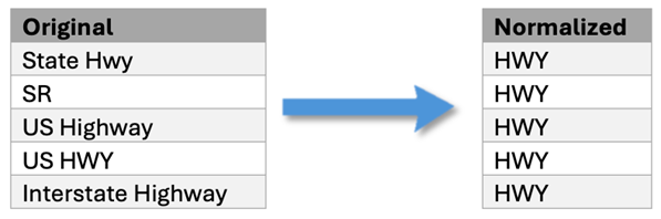
In both examples, the intent of the original data is no longer available to users. By constraining data to a single representation, contextual detail about the street type and street name is absent. For the maintenance of comprehensive address data, this is an undesirable outcome.
Address normalization can be challenging to implement; there are always some edge cases where errors are introduced into the data and false positive matches are the result. Esri has built a geocoding system where normalization is minimized to preserve the original authoritative data, thereby maximizing the quality of address validation by not changing the original authoritative address source.
Authoritative Address Data
We’ve used the concept of an authoritative address data source above. Some great authoritative sources are local governments who are responsible for managing local property ownership, building permits, tax rolls and more. These local sources are key in ensuring address data is collected and managed to support local activities. Esri is focused on supporting local agencies who manage authoritative addresses, with a pathway to have their data used in Esri’s geocoding system.
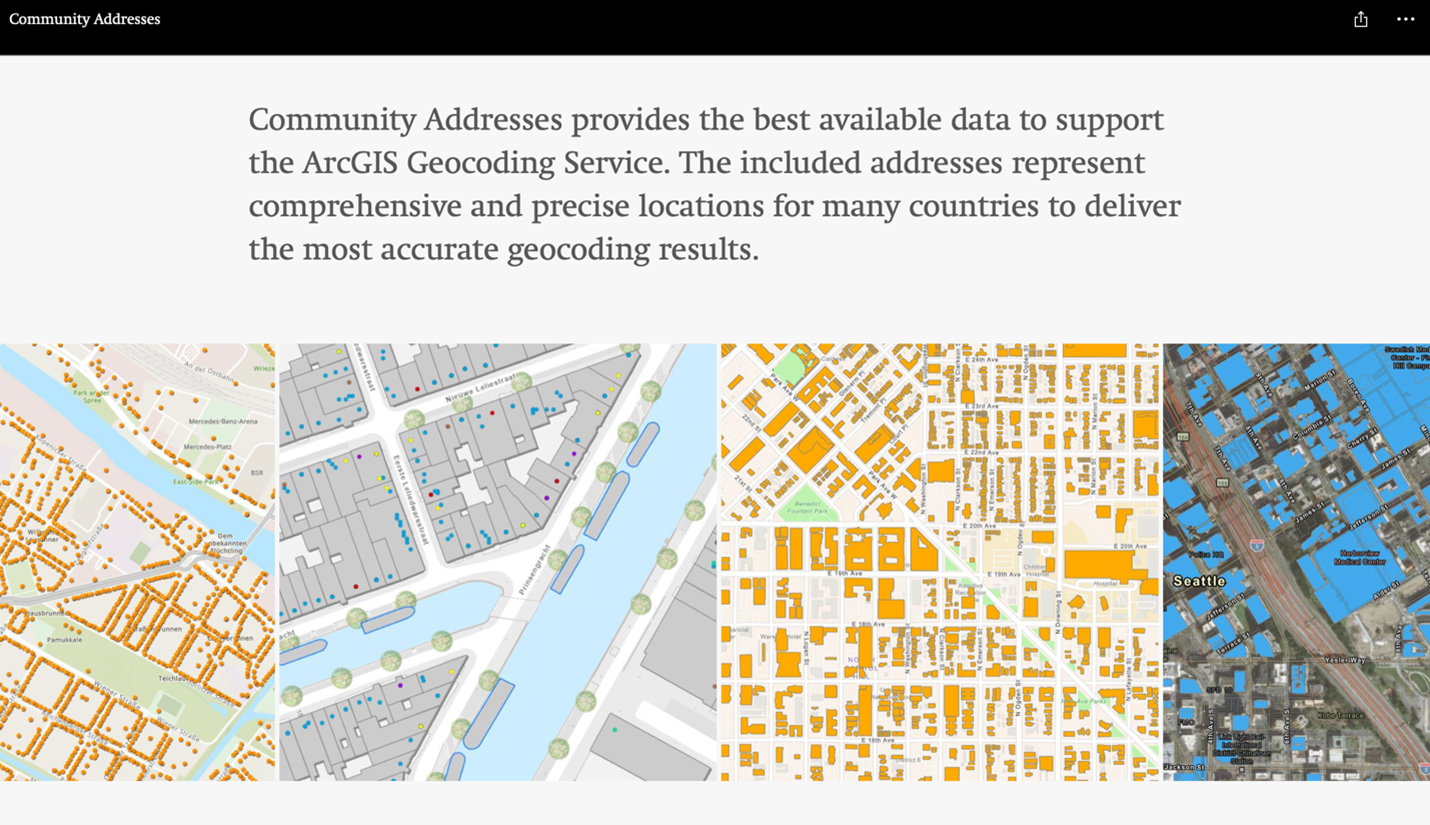
The ArcGIS Community addresses program allows local organizations to feed their curated data directly through to Esri for inclusion in our geocoding capability. That way we can validate and verify the existence of an address against the most comprehensive up to date sources. At the same time Esri is working with commercial organizations who are focused on building out addresses for interior spaces such as apartments and units. This helps us achieve the broadest possible coverage and the most comprehensive data to geocode or validate addresses against.
Address IDs
You may have also heard about address IDs, and are wondering what these are and how they can be used? The output from Esri’s geocoding can include a Match ID. This is a unique ID for each individual address. The Match ID can describe all forms of the same address in a single way. This ID can also be saved and used to query the geocoding system later to learn if an address has been repositioned or something like a postal code has changed.
Address ID’s help you tie observations back to a single address even when a single address can be represented in multiple ways. Consider these two inputs:
- Input address 1: 380 NY St, Redlands, CA 92373
- Input address 2: 380 New York Street, Redlands, California 92373
These are logically the same address, both addresses would be verified and assigned the same ID.
- Match ID 1 : AQFV9QAAmeQBAJUBBAAAAAAMD05FVyBZT1JIFNUUkVFV
- Match ID 2 : AQFV9QAAmeQBAJUBBAAAAAAMD05FVyBZT1JIFNUUkVFV
You could append this ID to your original records and use it to find duplicates. Organizations will implement workflows to see if new addresses that flow into their system already exist. They would geocode the new address, get back the ID and then search a database to see if that address is already present. If it is, it may have some interesting data associated with it that might also apply to the new observation.
Geocoding: The All-in-One Approach
Esri’s geocoding capability is an address validator, it produces standardized verified addresses, as well as address IDs which can be used for address deduplication, address querying and more. Learn more about geocoding with ArcGIS Pro as well as the ArcGIS Geocoding service within ArcGIS Location Platform.
Or visit the ArcGIS Data page to learn more about Esri’s data and data-driven capabilities.


Article Discussion: