In my new role at Esri as an Account Executive for the Imagery GBD (Global Business Development) team, I have been talking to many different aerial companies over the past several months. In these conversations I keep hearing the same thing: we focus on traditional orthomosaics because it is cheaper to produce, and our clients are not requesting it. I hear the same kind of logic when talking to our clients – we request traditional orthomosaics because we do not want to pay for the additional cost of true orthos.
While this logic may have been true several years ago, we are now facing a different reality which requires a different mindset. But before we dive in, let us take a second to review the difference between a traditional orthomosaic and true ortho:
Traditional orthomosaics are created from aerial images by first generating a 2.5D raster representation of the terrain called a digital surface model (DSM). Because a raster cannot accurately depict multiple heights at the same location, such as buildings and trees, these vertical objects are edited out to create what is called a “bare earth” DTM (Digital Terrain Models). The traditional orthorectification process then uses this model to correct the displacement caused by this terrain for each image, and then stitches together the corrected images into an orthomosaic. These orthomosaics have limitations for producing accurate maps, especially when dealing with built-up areas such as cities and industrial areas.
True orthos, on the other hand, use aerial images to produce an incredibly detailed 3D point cloud and then a specialized algorithm is used to decide which pixel from which image needs to be taken for any 3D location. The ortho is built by making this decision for each pixel until the entire ortho has been built. This process allows for more accurate mapping of 3D objects such as buildings, trees, and other structures.
The market for true orthos can be split into five primary domains: Countrywide Mapping, City Mapping, Site Mapping, Corridor Mapping, and Defense.
When mapping groups create large area orthomosaics for National, State, and Local governments from high-resolution aerial imagery, they require robust production engines with a high level of accuracy in an efficient and automatic processing workflow, advanced aerial triangulation, and quality assurance tools for review and editing. Utility companies often execute linear corridor mapping from both manned and unmanned assets with applications ranging from the monitoring and inspection of pipelines, roads, railroads, transmission and distribution powerlines, emergency response routes, and security.
Organizations like aerial survey companies, the AEC (Architecture, Engineering, and Construction) sector, and surveying offices use imagery for mapping applications to generate true orthos as products that can easily be integrated into their applications and solutions. These include temporal visibility into construction sites for planning building footprints, inspections, or agricultural development.
While it appears that producing a true ortho is more expensive and complicated, the latest algorithms have become more efficient, and the lowering costs of hardware can reduce the costs compared to a traditional orthomosaic. In addition, in a traditional orthomosaic workflow there is a need to verify and edit the seamlines created by the stitching process. This is not the case in a true ortho workflow as there are no seamlines created.
True orthos provide a more accurate representation of the terrain, which can be beneficial in a wide range of applications, including surveying, land management, and infrastructure planning. True orthos also provide more detailed and visually appealing maps that can help clients make better-informed decisions. True orthos are also crucial for Deep Learning models and AI (Artificial Intelligence) when used to extract building footprints. Humans can estimate the footprint of a building even when it is “leaning” but this is not accurate enough for AI. These algorithms will draw the footprint as they see it which will convey its correct location or shape. Finally, urban areas that have been mapped with true orthos over several periods can be easily compared using automated change detection methods. This capability can assist clients in understanding and quantifying which parts of their areas have undergone change.
In Europe, national mapping agencies in several countries such as Germany and the Netherlands are already requiring true orthos to be produced for any project they need. This is based on the realization of the advantages of these products and their superiority in accuracy when compared to traditional orthomosaics. Aerial providers are complying with these requests and demanding more accuracy and efficiency from the software vendors that they work with. The Esri team in Stuttgart has been working with these clients for the last 10 years and have implemented many of the requirements into the new Reality Engine they have developed, and which has been integrated into the new ArcGIS Reality product.
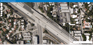
This product was just recently released and is now giving our clients the capability of generating true orthos straight from ArcGIS Pro with ArcGIS Reality for ArcGIS Pro or from the standalone ArcGIS Reality Studio application. The orthomosaics produced can be instantly shared to other stakeholders in the organization by publishing them as image services in ArcGIS Online or ArcGIS Image Server. In addition, the Reality Engine utilized in ArcGIS Reality has a unique algorithm which can remove any moving object that may appear in one image but not in the subsequent image. With this feature, highways show up as empty and parking lots still show the cars that are parked there. This benefits all kinds of use cases from transportation planning to roadway inspections and makes change detection much more accurate and quicker.
In summary, although producing a true orthomosaic may require more advanced software and expertise, the cost advantages can be significant. For clients, true orthos provide a more accurate and concise representation of the area covered, resulting in more informed decision-making. For aerial providers, processing your imagery to generate true orthos is becoming easier and less expensive and should be considered part of the different outputs you deliver to your clients.
Article Discussion: