Here is a map showing 40 years (and 8,000 incidents) of nautical piracy.

Source data with heavily overlapping points, like this, can obscure areas of ultra high-frequency, looking no different from moderate clusters of activity. Aggregation can be a good viz option, and it also provides little cells within which you can create statistical summaries (which I’ll do in a follow-up map). Of course, if you must aggregate, then you should probably use hexagons. Glorious hexagons. And, if you are aggregating into hexagons then they darn well better be equal area (made easy for you via the unstoppable Bojan Šavrič’s Equal Earth projection, available in Pro).
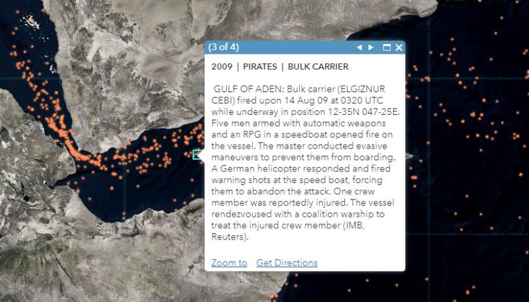
The data comes from the National Geospatial-Intelligence Agency in the form of an “Anti-Shipping Activity Messages” database that they helpfully provide for reasons of prevention, avoidance, analysis, that sort of thing.
Here is a web map version of this that you can zoomy-clicky within. But be warned, once you start reading the descriptions of these incidents you will be sucked in like I was in 7th grade when I stayed up all night reading the novelization of Hook (which also has pirates)…
If, for some reason, you would like to see/hear this nasally Midwesterner build this map, here is a hastily-produced YouTube video where I do just that. You can follow along and build your own, downloading the source data and building your hexagonal tessellation. Or you can be a total slacker and just use these nice tidy resources:
- Firefly basemap
- Piracy points feature service
- Piracy hex-bins feature service
- Global background layer for sneaky vignette creation
- ArcGIS Pro Firefly style
In this one map, we’ll cover…
- Data wrangling
- Defining a layer’s projection
- Adding layers from the Living Atlas
- Modifying a map projection
- Creating a vignette effect
- Using an ArcGIS Pro style
- Generating a tessellation
- Spatial join magic
- Graduated symbology
So get ready to live.
Happy Mapping! John

Commenting is not enabled for this article.