There’s something wrong with your data’s coordinate system, but what to do? Which tool is the one for you?
• If your data doesn’t have a coordinate system, or you suspect it has the wrong one, you want Define Projection.
• If your data already has a coordinate system but you wish to convert it into a different one, you want Project.
Here’s an analogy:
You bought some things online.

Your receipt shows that you paid $44. But your credit card was charged $45.22. That’s not cool – where did that $1.22 go? Why doesn’t the data match up?
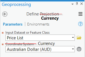
You think perhaps there’s something wrong with the currency. You live in Australia, so you want to make sure those dollar amounts are in AUD. You run the Define Currency tool with your price list and choose Australian Dollars.
You look at your new price list and discover that the tool did not solve your problem. The total still doesn’t match your credit card statement:
| Shoes | $24.00 AUD |
| Hat | $12.00 AUD |
| Water Bottle | $8.00 AUD |
| Total | $44.00 AUD |
Why didn’t Define Currency work?
You should have taken a closer look at your metadata:

You read the fine print on your receipt and discover that the company you bought the stuff from is in Canada. Those prices were in Canadian dollars. The correct workflow for your problem is:
1. Run the Define Currency tool and choose Canadian dollars:

Your new price list looks like this:
| Shoes | $24.00 CAD |
| Hat | $12.00 CAD |
| Water Bottle | $8.00 CAD |
| Total | $44.00 CAD |
2. Run the Convert Currency tool and choose Australian:

Now the price list looks like this:
| Shoes | $24.37 AUD |
| Hat | $12.33 AUD |
| Water Bottle | $8.22 AUD |
| Total | $45.22 AUD |
And it matches your credit card statement correctly. Mystery solved.
The workflow is the same when your geographic data doesn’t line up.
You need to know – and define – what the original coordinate system is before you can convert it into a different one. If you start with the wrong coordinate system, you will be using the wrong transformation, and the result will have the wrong coordinate values.
Define Projection
If your data is not drawing in the right place, it may not have a coordinate system defined yet, or it may have the wrong one. You need to Define Projection before you can continue.
• Check Layer Properties > Source > Spatial Reference to find out what coordinate system your data is in. If it says “Unknown Coordinate System” you definitely want to use the Define Projection tool.
• The Define Projection tool will not make a copy of your data. It will only change the metadata of the existing dataset. If you run this tool and guess the wrong coordinate system, you’ll make things worse. But the good news is that none of your actual coordinate values have been changed, so if you are able to find out the right coordinate system, and you run the tool again, your data will be fixed.
Project
Once you have defined the correct coordinate system, you should be good to go. ArcGIS Pro and ArcMap will project-on-the-fly to make your data draw with whatever coordinate system your map is using, and it will draw in the right place. However, if you want to make sure that all of the data you are using in a project has the same coordinate system – for consistency and accuracy in analysis and editing, or to minimize reprojections in a project or layer – then you should run the Project tool. This will make a copy of your data and convert it into a different coordinate system.
• Note that raster datasets should be converted using the Project Raster tool instead.
• Sometimes (when the datums are different) a Transformation is required. If you don’t know which transformation to choose, the first one in the list is your safest choice.
What’s the difference between a Coordinate System and a Projection anyways?
Don’t be deceived by the names of these tools – Project and Define Projection – you can use either of them without ever using a projection. Why? Because they are actually defining and converting Coordinate Systems.
• What is a Geographic Coordinate System (GCS)?
This is the imaginary grid you are drawing over the earth’s surface in order to define where things are. The main ingredient of a GCS is the Datum. The same latitude and longitude values will draw in different places on the earth when using a different GCS. Your data needs a GCS before it can know where to draw.
• What is a Projected Coordinate System (PCS)?
This is a combination of a GCS + a Projection. The GCS tells your data where to draw on the earth, and the projection tells the map how to distort the earth onto a flat surface. Every PCS contains a GCS.
Here’s the recipe for a Projected Coordinate System:
Projected Coordinate System (PCS)
1 Linear Unit (e.g. Meters)
1 Projection (e.g. Transverse Mercator, Stereographic, etc.)
Various projection parameters (depending on the chosen Projection)
1 Geographic Coordinate system (GCS)
1 Angular unit (e.g. Degree)
1 Prime meridian (e.g. Greenwich)
1 Datum (e.g. WGS 1984)
1 Spheroid
To learn more, read these other articles that I have written about coordinate systems:
- Geographic vs Projected Coordinate Systems
- Coordinate Systems: What’s the Difference?
- Projection on the fly and geographic transformations
- Transformation warning: What does it mean and what should I do?


Commenting is not enabled for this article.