There’s nothing more satisfying to my teammates and me (Hannah Wilber) than stumbling upon a truly tremendous story made by the StoryMaps community. Whenever that happens, we can’t help but share it with just about anyone we can think of. Such was the case when we came across The Voices of Grand Canyon, a masterpiece and collaboration between the Grand Canyon Trust and Havasupai, Hopi, Hualapai, Navajo, and Zuni storytellers. I forget which of us found it first, but it didn’t take long for the Slack channels to be buzzing about it, emails sent to the higher ups, and social media posts shared. We were excited.
The story does a lot of things really, really well:
- It’s driven by first-person narratives, providing real people for readers to connect with. This is such an effective technique for engaging an audience, and is something we wish we saw more of.
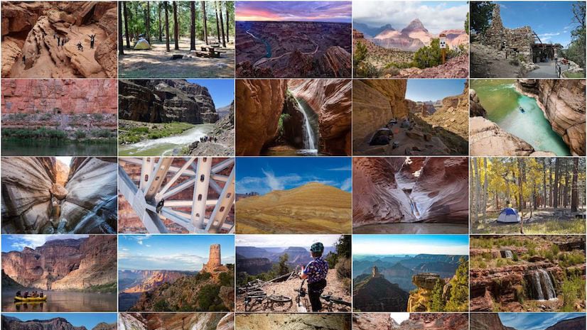
- It skillfully combines a variety of different media—videos, audio clips, photos, and minimal maps—appealing to a variety of senses and bringing the people and their lands to life.
- It’s organized into sections that each follow the same pattern, providing ample opportunities for readers to pause and absorb the information they just learned, then keep them moving through the story. It’s clear a lot of thought went into optimizing this reading experience.

Of course, the first thing that comes to mind for us when we see a great story like this is “how can we help others learn from the talented team that put this together?” To that end, I’m delighted to tell you that Stephanie Smith, the GIS Program Director at Grand Canyon Trust, Ellen Heyn, the Trust’s Communications Manager, and Sarana Riggs, the Grand Canyon Program Manager, will be joining us in our upcoming installment of StoryMaps Live! This is our recurring, free webinar series; if you’re looking to hear more about the latest enhancements to ArcGIS StoryMaps and learn from superb storytellers, you don’t want to miss it.
The next installment of StoryMaps Live is on Wednesday, June 17th, at 2pm Eastern. You can register to attend here.
But a webinar wasn’t enough, so I also chatted with Stephanie and Ellen to get into the weeds of their process. The conversation that follows (which has been edited slightly for length and clarity) is chock full of great insights from them both. Take the time to make your way through it—I promise you won’t regret it.

About the interviewees:
Fueled by a passion to live in the West, Stephanie uprooted her life in North Carolina and joined the Trust in April 2012 to build the GIS Program for the Trust. She has a M.A. and B.S. in geography from Appalachian State University with a focus on biogeography and geographic information systems. Prior to joining the Trust, she served as the GIS specialist for the ASU Energy Center and as an instructor for Appalachian State University’s Geography Department. She often calls herself the nerd behind the map, but she is much more than that. She is an avid hiker, cook, crafter, and community activist.
A Grand Canyon river trip prompted Ellen to leave her home state of Wisconsin and begin her post-grad adventure in the sunny Southwest. After living as a desert vagabond for several months, slickrock captured her heart in a way no dairy farm ever had. She landed in Flagstaff in 2013 and started working for the Trust shortly thereafter. She puts her journalism and environmental studies degrees from the University of Wisconsin-Madison to good use writing for the Colorado Plateau Explorer and managing communications for the Trust.
Hannah: To get started, can you tell me how storytelling fits with the Grand Canyon Trust’s overall mission?
Stephanie: We’re a conservation advocacy organization, whose mission is to safeguard the wonders of the Grand Canyon and Colorado Plateau, while supporting the rights of its Native peoples. So messaging around public and tribal lands in our geography is central to our mission. Combining maps with interactive deliverables and text creates a larger platform we can use to advocate for environmental and cultural protections.
Ellen: In terms of how we do that, certainly, facts and research matter. But it’s really stories, we’ve found, that drive people to take action. So by sharing stories—specifically people’s stories connected to the landscape—we can grow the community of advocates willing to speak up for the Colorado Plateau.
H: What sets a great story apart from an average story, in your experience?
E: I think great stories bring us into worlds we know little about—they invite us to learn, expand our knowledge, challenge our beliefs. The featured storytellers in The Voices of Grand Canyon really hook the audience by speaking from their hearts.
S: On the technical side, one of the really important pieces of pulling together an interactive story is giving multiple avenues for people to get to the same information. Everyone digests stories in different ways: Some digest text better, others need more visuals. Accounting for that diversity of experiences is really important for digital storytelling.
H: So how do you approach a new storytelling project? What does that process look like?
S: The process varies, but story projects at the Trust are always grounded in the work. For Voices of the Grand Canyon, the idea came from a group of Native leaders who, in advance of the centennial anniversary of Grand Canyon National Park, formed the Intertribal Centennial Conversations group. Their goals were to commemorate their Indigenous presence, share their true history, and promote greater involvement of the Grand Canyon’s first stewards in managing the park. So Communications and GIS at the Trust, along with Deidra Peaches, a Diné (Navajo) filmmaker, helped develop a project that worked toward the group’s goal.
I think great stories bring us into worlds we know little about—they invite us to learn, expand our knowledge, challenge our beliefs.
Other times, it’s an idea originating from the GIS program. We see a lot of data coming across our desks and notice the interconnectivity between the data and relevant topics, so we pitch an idea. But the connection between the GIS program and the Communications team is central to all of the different story products we produce. I think the most popular ones and the best ones we produce have been those where it is a collaboration between our GIS and Communications staff.
H: That’s something I love to hear; we’re always trying to push those two departments together when we get the chance to work with organizations. It’s so clear that when you get Comms and GIS working together, that’s when the magic happens.
E: Steph’s right. There is a lot of back and forth between Communication and GIS. Ideas get floated past each other, and from the outset, we have a lot of conversations about the vision and goals for each project.
H: Since you’ve already started talking about it a little bit, can you share more about what creating this piece involved from start to finish?
E: Sure. So, as Steph mentioned, the original idea came from the Intertribal Centennial Conversations Group—they wanted people to know that the Grand Canyon wasn’t 100 years old, that their history dated back to time immemorial. So that was really the overall framework for the project. The way we conceived of the story map was as a platform to share some of those stories.
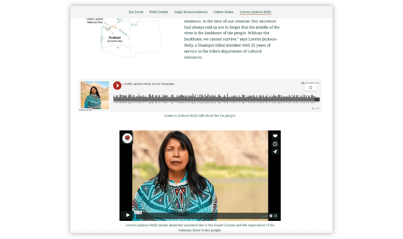
The heart of The Voices of Grand Canyon is interviews. We worked with Deidra Peaches, a Navajo filmmaker, who traveled across the plateau to interview Jim Enote, Nikki Cooley, Leigh Kuwanwisimwa, Coleen Kaska, and Loretta Jackson. It was important to conduct the interviews on each person’s ancestral land to expand people’s understanding of cultural connections to the Grand Canyon. And after the storytellers gave the final sign off on their respective pieces, the content went to Steph.
S: Right, so then Ellen hands off all the content to me, and I take the content and create all kinds of different editions, testing different ways to have the content come together. How do we want to have the videos work, what kinds of embeds do we want to use, what looks best, what flows the easiest?
For this specific story it was about a month of solid work testing and re-testing, doing and re-doing, over and over until we had something that we both could look at and agree it felt smooth and was flowing the way that we wanted it to. We also made sure to run the final product by the interviewees and our colleagues who work with the Intertribal Centennial Conversations group to make sure it honored the intent and goals of their work; that was a really important step.
H: Any advice for teams who want to start doing this kind of collaborative storytelling?
S: From the GIS perspective, you really have to focus in on the story itself—what’s the purpose and who’s the audience? You sometimes need to let the GIS take a backseat and allow the story to shine, by letting those with a keen eye for stories take the lead. As a geographer and cartographer, I can use the tools and tricks of my trade to support that end goal.
And you need to have direct communication with each other.
Basically, you need to have a clear sense of what the Communications goals are for the product, as well as what the GIS goals for it are, and find the right way to intertwine those in one cohesive piece. It also helps when you really like working with each other.
The connection between the GIS program and the Communications team is central to all of the different story products we produce. I think the most popular ones and the best ones we produce have been those where it is a collaboration between our GIS and Communications staff.
H: Since you mentioned the importance of goals, can you talk about the goals for The Voices of the Grand Canyon?
E: The primary goal was to broaden the narrative of Grand Canyon National Park. It’s not just a vacation destination—it’s a cultural homeland to many Native peoples. But those stories are not mine to tell, they’re not part of my experience, so the first-person story narrative was critical for this project—that the people who wanted to tell their stories were actually the ones doing the telling. That’s why the video component was so important, and the reason behind including audio clips, too. The more we could have those stories told in each person’s own voice, the better.
S: And as an organization, we take a support role in our Native America work. We were grateful to be able use the tools available to us as an organization to provide a platform for sharing these stories.
H: One of the things we’ve really loved about this story is how effectively you wove together so many different types of media. Can you talk to me a little about your strategy for bringing those pieces together?
E: Deidra’s videography and photography were really central to the project, giving it visual continuity and flow. We ended up with a massive amount of content from each storyteller, and so the audio clips were a way to include some of the extra bonus content that didn’t make it into the videos.
S: In terms of stringing things together, we sat back and talked about how we could elevate the first-person narrative as our number one goal. As much as possible, we wanted the storytellers to speak for themselves. We had a lot of back and forth on how best to string things together. Ultimately, it needed a bit of connective tissue to bring everything together. When designing the interactive product, and you yourself feel a bit of a hiccup or pause, then your audience is probably going to feel that as well. So we tried to do the minimal stitching necessary to create a cohesive piece.

All the elements—videos, audio, photos, and text—work together to achieve a sense of place, so that even if you’re more visually inclined than audio inclined, you can still get a sense of what it’s like to be on Jim’s farm with him standing in the grasses.
H: It was definitely impressive to see how consistent the cadence of the story was from one person to the next. It really helps move the reader along.
S: In terms of layout, we needed to keep everything consistent. Maps were going to be the same, the lead image would be sized the same, each one had a heading in the exact same spot.
We didn’t want to necessarily dictate the flow a reader would take, and thankfully the story bookmarks allow that, but we did have to start somewhere and put the content in some kind of order. But if you do use the bookmarks to jump around you won’t feel like you’ve missed anything, because the layout and experience is consistent, making the order in which you explore them less important.
I think sometimes the hardest thing to decide is what not to put into a story. We probably have more content that didn’t make it into a story than content that did. There were a lot of decisions that had to be made about how much extra content to include with each individual section, because we didn’t want to add so much that it distracted from the video and audio clips. That way the individual reader stayed focused on those first-person pieces.
E: That’s definitely true. It came down to figuring out what nuggets to use in what ways, and then how we can share the rest of it in different projects.
S: It’ll still get used, just not in this story.
The more we could have those stories told in each person’s own voice, the better.
H: It sounds like content scoping definitely involved some tricky decisions to navigate; were there any others that came up as you were working?
S: A lot! A funny thing is, the first draft I gave to Ellen didn’t have any maps. As an organization, we’re always very careful about what we map in terms of culturally sensitive information. So the challenge was how to add something that can be mapped that doesn’t give away anything sensitive while being respectful. Because of that I was hesitant to put any boundaries on a map, so we had to be very careful in our cartography.
But I think where we landed with the simple maps is that they really do help orient the readers as to where the individual people live.
H: Now that the story has been out in a while, do you feel like it’s achieved what you hoped?
E: Yeah, it’s been really cool to see it shared so widely within the social media world! I think that’s a testament to the work that the Intertribal Centennial Conversations group is doing to elevate Native voices.
S: It surprised me how quickly it started to spread, kind of like a wildfire. We put it out there and suddenly I had random people emailing me about it, and I was just wondering “how did you already see it? We just launched this!” Ellen did a massive media campaign on this leading up, with a lot of planning to get it out the door, and that was a huge component of getting it out into the world.
E: The launch coincided with the 101st anniversary of Grand Canyon National Park, which kind of came full circle, stepping firmly into the second century of Grand Canyon National Park with these Native voices leading the way.
There is clearly a hunger for those stories and that knowledge—the reception that Voices of the Grand Canyon received is just a testament to the fact that the world needs to hear these stories—and more of them.

Article Discussion: