Today, professionals from leading sectors are requiring that college and university graduates have a large knowledge base so that they can reduce the amount of on-the-job training in their specific domain. While in the past this was focused mainly on GIS and vector information, it has now expanded to include image processing and analysis. By combining the geoprocessing capabilities of vector data with powerful image processing and analysis tools, Esri technology offers students, staff and researchers the full spectrum of options to pursue a comprehensive career in a wide array of industries. With Esri technology knowledge, graduates can also better share and discuss actionable information by using Dashboards, Web Apps and Web Maps.
Esri has a rich history of pioneering the GIS domain with market-leading software products that help professionals in multiple industries make informed decisions by using location-based analysis. The products Esri developed have mostly focused on vector data while raster data was used as either an auxiliary data source or as an intermediate format for data analysis. In the Education sector, teaching staff have been using Esri software in beginner and advanced courses that focus on GIS and mastering Esri software has become a cornerstone for young professionals who wish to pursue a career in the geospatial industry. For imagery, Esri software has always had some options to process and analyze this type of data. Over the past decade, as imagery data sources have become increasingly more prevalent, new products and solutions have been developed to accommodate this change. So, while Esri has always been viewed as company that focuses on vector information, it is increasingly changing this perception by offering new ways in which imagery can be processed and analyzed all while leveraging its long history of analysis tools and platforms.
With the rise of drone platforms and the decreasing costs of developing, launching and analyzing satellite imagery, the imagery community has also expanded and now includes people from many different disciplines. These developments have meant that colleges and universities are being asked to teach more people how to use these platforms and how to leverage the data they can collect.
Many academic institutions in the US and around the world that teach GIS are familiar with Esri software and most likely incorporate it in their courses and research. Those same institutions also teach Remote Sensing but use other software packages or open-source offerings for this purpose. This situation creates a growing gap between students of GIS and those of Remote Sensing. Students graduating with a GIS degree enter the workforce without much knowledge about imagery and those with a Remote Sensing degree have little to no knowledge of GIS technology. Meanwhile, the business world is seeing these two domains grow closer and become more intertwined as technologies evolve and spatial knowledge is becoming more mainstream in different domains.

At Esri, we believe the two disciplines should be taught more tightly together and using a unified platform to increase the knowledge of GIS by Remote Sensing students and the knowledge of Remote Sensing students by GIS students. ArcGIS provides desktop and online technology to help students bridge this gap:
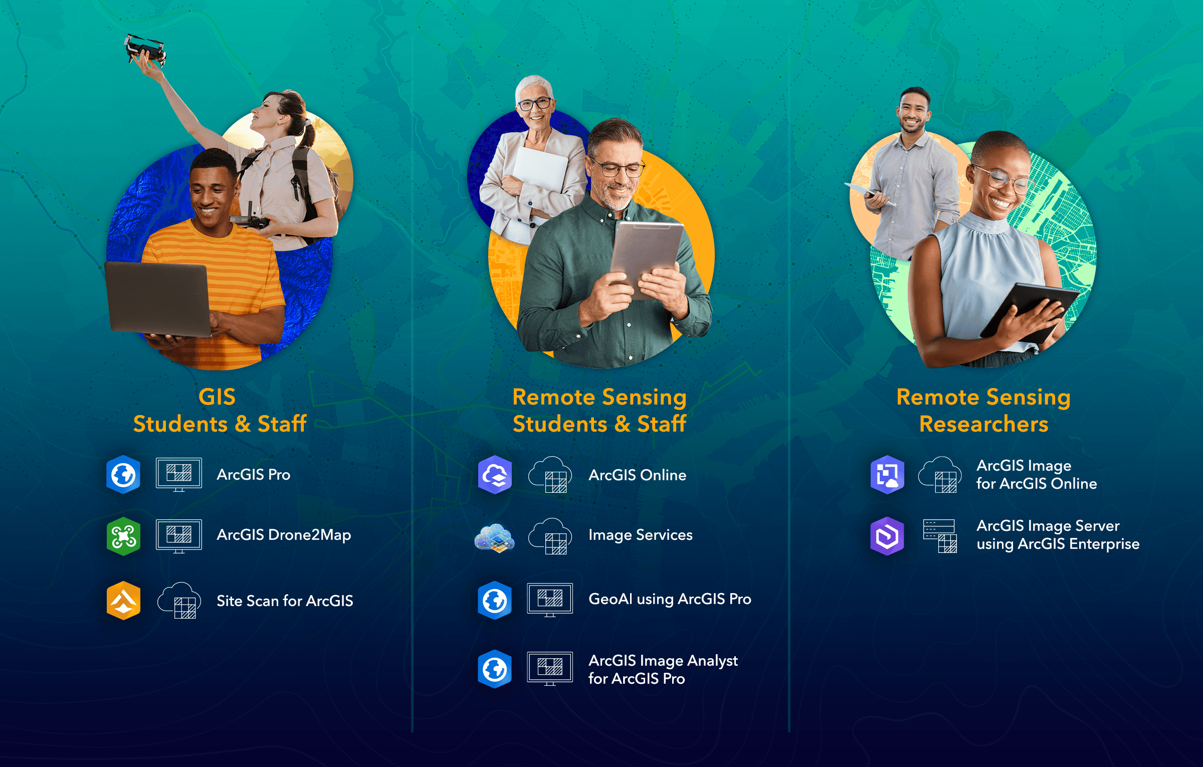
- For GIS students and staff that are already familiar and comfortable working with ArcGIS Pro, an Advanced license provides an orthomapping workflow that can process drone, aerial and satellite imagery to create 2D products such as an orthomosaic and elevation models.
- For GIS students and staff that have yet to work with ArcGIS Pro and prefer to work in a desktop environment, Drone2Map for ArcGIS is a great software that can process drone imagery and create 2D and 3D products such as true orthos and 3D textured meshes.
- For GIS students and staff who prefer to work in a cloud environment, Site Scan for ArcGIS is an online solution with the same underlying processing engine as Drone2Map, but all images must be uploaded to the cloud.
- For Remote Sensing students and staff that want to work in a desktop environment, ArcGIS Pro has an Image Analyst extension which offers many valuable raster functions and geoprocessing tools for image analysis and Deep Learning topics. ArcGIS Pro also includes hundreds of geospatial functions and tools to enable students to learn about GIS and how it can be used in combination with imagery.
- For Remote Sensing students and staff that prefer to work in a cloud environment, ArcGIS Online provides many of the GIS functions available in ArcGIS Pro but in a web-enabled environment that does not require any advanced hardware. In addition, ArcGIS Living Atlas in an online repository which includes hundreds of image services and Deep Learning Models
- For Remote Sensing researchers that need large scale raster analysis, ArcGIS Image Server can be configured on premise to run on any number of images and ArcGIS Image for ArcGIS Online can perform the same while utilizing the Esri cloud infrastructure to reduce IT overhead.
In general, many educators today prefer to work with one single technology package to simplify course materials, reduce costs and reduce the learning curve for their students. Esri’s technology now has this advantage as it combines multiple technologies in a single powerful desktop application which also seamlessly connects to an online platform for sharing and collaboration.
In addition, Esri has a large repository of online courses that cover different topics in GIS and Remote Sensing which educators can utilize to engage their students. The Esri Education Team can also work together with staff members on modifying their current syllabus to include Esri technology and modernize their teaching to better equip their students going into the workforce.
Teaching Staff
Teaching staff in educational institutions can incorporate Site Scan for ArcGIS, Drone2Map or ArcGIS Reality for ArcGIS Pro in their Remote Sensing courses as part of the drone mapping lessons or as Remote Sensing modules in GIS courses. All products are drone agnostic and can process most of the sensors that are currently being used and can be incorporated in many different classes to cover basemap creation of an area, multi-spectral and thermal imagery, and 3D object reconstruction. For more advanced courses, these products support adding Ground Control Points to generate more accurate outputs and to enable accurate change detection between basemaps of an area collected at separate times. The software packages also have basic analysis tools such as NDVI, contour creation and elevation profiles which teachers can use in various drone mapping courses.

Researchers
Research fellows or researchers can use Esri drone mapping software to generate 2D orthomosaics of their drone imagery, share the results with their colleagues using ArcGIS Online or ArcGIS Image Server and then run different analysis using the many Raster Functions and Geoprocessing Tools available in ArcGIS Pro or ArcGIS Online. SiteScan for ArcGIS and ArcGIS Drone2Map also support multi-spectral drone imagery and generate products such as NDVI which is commonly used in plant health studies. In addition, bio-mass estimates can be made by generating point clouds and different Surface Models to support Forestry research. These packages can also generate 3D textured meshes that are useful for accurate simulations of urban environments and for various 3D analysis tasks such as understanding the effects of shade and line of sight in built-up areas. Researchers can use any type of drone to fly and capture the imagery as the product supports most sensor types. Our team is also extremely interested in learning about new sensors being used and working with you to add them to the growing list of supported sensors.
In conclusion, with the rise of imagery data collection options and a subsequent explosion of content being generated, Esri now has many tools to help researchers process this data, analyze it and deliver it to other stakeholders as actionable information and for educators to use as teaching tools for their students. Coupled with traditional GIS technology, imagery is becoming more widely used, and workplaces now expect graduates to know how to collect and analyze this data source for their needs. Integrating the available Esri products for image processing and analysis into existing GIS courses is imperative to help keep your students updated and become better prepared to enter the workforce. In addition, academic institutions that want to start teaching about drones would greatly benefit from Esri’s offerings as it encompasses easy to use products for beginners alongside our industry-leading GIS technology to bring students the best of both worlds – Imagery and GIS.


Article Discussion: