The latest release of Oriented Imagery is here! New enhancements in Oriented Imagery 2.5 include support for a 3D viewing experience in ArcGIS Pro 2.6, the ability to click on exposure points to view images in the ArcGIS Pro and web app viewers, an upgrade to the ArcGIS API for JavaScript 4.16, and more.

What is Oriented Imagery?
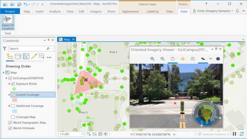
Oriented Imagery is a community-supported solution from Esri for managing, viewing, and exploiting imagery that’s not pointed straight at the ground—street side photos, inspection images, panoramic imagery, and more. Oriented Imagery includes:
- An ArcGIS Pro add-in for viewing and exploiting oriented imagery
- Geoprocessing tools for managing and publishing oriented imagery
- Web apps for viewing and sharing imagery in 2D and 3D
- Development tools for customizing your own solutions
If you’re new to Oriented Imagery, check out our earlier blog to learn more about what it can do and how to get started. You can also try out a new set of example web apps demonstrating Oriented Imagery using a variety of imagery types, including GoPro imagery, point clouds, and more.
What’s new in Oriented Imagery 2.5
Oriented Imagery 2.5 includes a variety of enhancements across the solution—
The Oriented Imagery add-in for ArcGIS Pro now includes:
- Support for viewing your oriented imagery in a 3D scene (ArcGIS Pro 2.6+)
- The option to click on an exposure point to view the image
- The ability to add an oriented imagery catalog to your map from the Catalog pane (ArcGIS Pro 2.6+)
- A default minimum viewing scale set to exposure points and the coverage map (if it’s not set manually)
With the Oriented Imagery 2D and 3D web apps, users now have the option to:
- Click on a photo location to view that image
- View exposure points as the coverage area if no coverage map exists
- Use a coverage map that has a minimum scale set by default
Additionally, the Oriented Imagery API now utilizes the ArcGIS API for JavaScript 4.16, offers improved calculation for the coverage map, and includes a new method for showing an image from the image ID. Oriented Imagery management tools for ArcGIS Pro have enhanced logging support and an improved user experience for creating coverage features.
How to get Oriented Imagery 2.5
To get the latest features with Oriented Imagery 2.5, download and install the add-in for viewing imagery in ArcGIS Pro and the geoprocessing tools for managing and publishing imagery. You can also access the updated web apps for viewing and sharing imagery in 2D and 3D, and find development tools for customizing your own solutions (including documentation on the Oriented Imagery API and oriented imagery catalog schema, plus an Oriented Imagery widget for Web AppBuilder) on GitHub.
Have questions or need help with Oriented Imagery? Create something really great you want to share? Let us know on GeoNet.

Article Discussion: