2020 Census
A census is administered in the U.S. once a decade to enumerate the nation’s population to ensure all inhabitants are counted “once, only once, and in the right place.” Census data products are released in phases and are behind schedule due to the impact of the COVID-19 pandemic. Redistricting Data (P.L. 94-171) marked the first detailed data release and have been available in Esri products since December 2021 for both the United States and Puerto Rico. The Redistricting Data release included information on demographic and housing totals, including race, ethnicity, group quarters, households, and occupancy status.
The second large detailed release from the 2020 Census is the Census Demographic and Housing Characteristics Files (DHC). This release includes more detailed and rich information on demographic and housing characteristics covering characteristics such as age, sex, race, Hispanic or Latino origin, household type, family type, relationship to householder, group quarters population, housing occupancy, and housing tenure.
For Esri’s October 2023 software and content release, select information from the DHC is available in Business Analyst (BA) products for 11 geographic schemas in the U.S., eight schemas in Puerto Rico, or can be enriched to any user defined polygon such as drive times or rings. This geographic portfolio includes non-Census layers such as ZIP Codes and Designated Market Areas (DMAs). Refer to our update inventory to view the full list of geographic summary areas available. Lastly, this information will be geographically updated annually for select schemas like ZIP Codes, places, and DMAs to reflect the most current summary area definitions.
In total, over 2,200 variables are included in BA which includes complementary derived measures such as select percentages, growth rates, population density, and more. Most data are available by block group summary areas and therefore can be leveraged by Esri’s GeoEnrichment (GE) Service to create data for user-defined areas. A subset of variables are geographically restricted to Census tract and higher that can be used for mapping and comparisons at higher levels of geography. For a full list of variables from the DHC, refer to Esri’s data catalog. For further information on this data set refer to the 2020 Census Esri Methodology Statement.
2020 DHC versus 2010 SF1
Disclosure Avoidance
While the 2020 DHC can be viewed as the replacement to SF1 from 2010, there are several notable differences that users should understand. The 2020 DHC incorporated differential privacy as the disclosure avoidance method while 2010 used table suppression and data swapping techniques. This can result in statistical abnormalities that were not present in the 2010 SF1 release such as the presence of households but no household population or household population but no households. To better understand how differential privacy impacts 2020 Census data, refer to the Differential Privacy Resources ArcGIS Hub for additional resources.
Data Availability Changes
Overall, with the 2020 DHC, users can expect to see less detailed information compared to the 2010 SF1. This includes both a loss of information as well as less geographic granularity for some data tables. Several tables that were published for Census block summary levels in 2010 are now only available for Census tracts and higher. For example, the household type by household size data table was released for blocks and above in 2010 (SF1 Table P28) but is now only available by tract and above in 2020 (DHC Table PCT7). To reduce the impact of this loss of geographic detail and allow comparisons between 2010 and 2020 for higher levels of geography, tract tables were included if those variables were also in Esri’s 2010 variable inventory. Note that PCT tables are not available for enrichment via Esri’s GE Service.
Definitional Changes
In addition to changes in data availability, there have also been definitional changes that impact comparisons of 2010 and 2020 data.
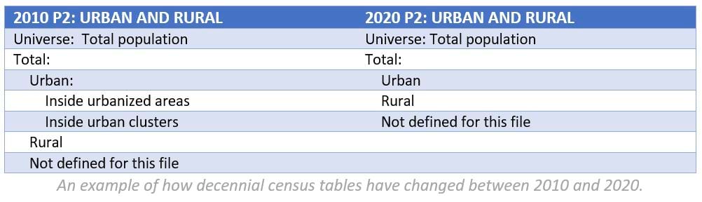
The Census Bureau implemented changes to the race and ethnicity questions on the 2020 census questionnaire to improve wording and examples. Additional changes to the 2020 questionnaire have allowed for various relationship types to be tabulated differently in the 2020 Census compared to 2010. For example, in 2010, if married couple households had the same sex, they were edited and tabulated as unmarried partner households. With the 2020 Census, questions on the relationship to householder were changed to account for more types of relationships and more modern views on marriage and household relationships. Information is now available on opposite-sex and same-sex married couple households. There have also been changes to the definitions of urban areas between the 2010 and 2020 Census. With the 2010 SF1, the Census Bureau defined two types of urban areas: Urbanized Areas (UAs) of 50,000 or more people and Urban Clusters (UCs) of at least 2,500 and less than 50,000 people. With the 2020 DHC, all qualifying areas have been designated as “urban areas” – the urban clusters classification has been dropped. The definitional and processing changes limit the usefulness of comparing these variables between 2010 and 2020.
Esri Conversion of 2000 and 2010 Data
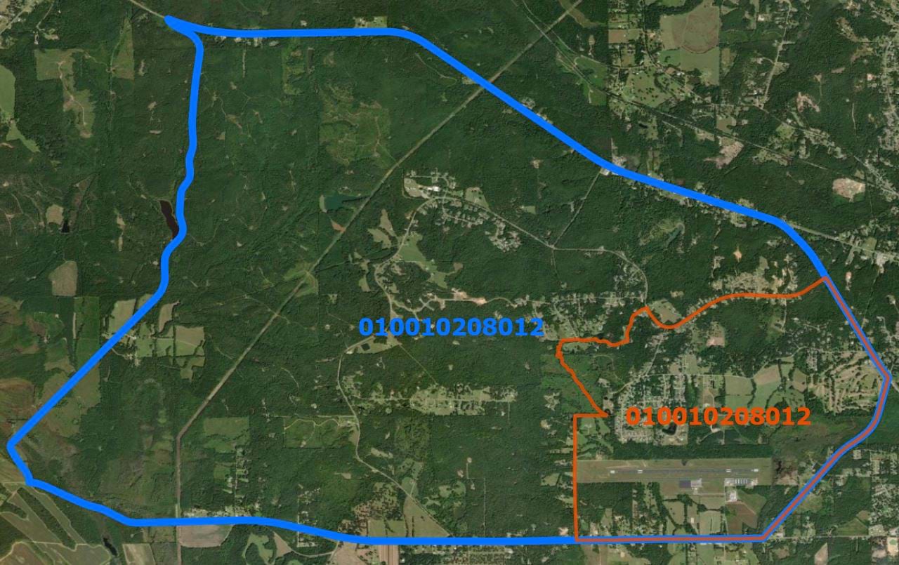
A final issue to consider when comparing 2010 and 2020 Census data is the change in boundaries that occurs between decennial censuses. Esri converted select SF1 variables from the 2000 and 2010 decennial censuses to reflect the same geographic boundary layers used in the 2020 Census data products, enabling temporal comparison. However, direct comparisons of 2010 and 2020 data as originally published is not advisable. For example, as the image below illustrates, the 2010 boundary (in blue) for block group 010010208012 has markedly changed in 2020 (in red). Esri developed a methodology to allocate data published in the original 2000 and 2010 geographic areas to the current 2020 Census geographic boundaries.
Using DHC Data in BA
The 2020 Census DHC data allows data users to access this information through Esri’s ArcGIS GeoEnrichment Service, ArcGIS Business Analyst web/mobile apps, ArcGIS Business Analyst Pro, and ArcGIS Community Analyst. ArcGIS Business Analyst as well as GE within ArcGIS Pro and ArcGIS Online allow users to build reports and infographics for any user-defined area.
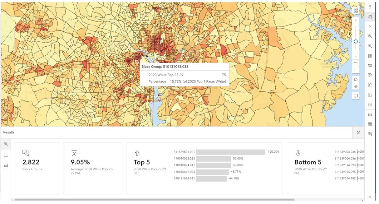
Users can access 2020 DHC data in BA by selecting “U.S. Census” as the source in the Data Browser to view the 2020 variables. Additionally, maps can be created based on these variables such as the percentage of the white population that is between the ages of 25-29:
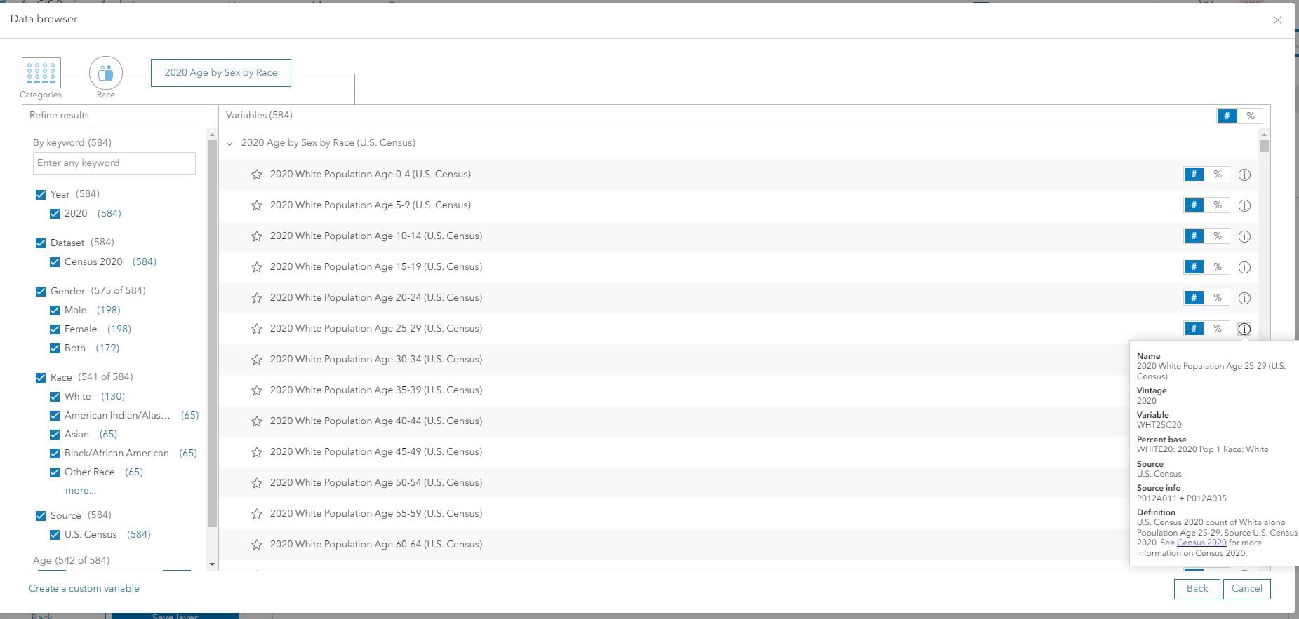
Users can hover over the information icon in the Data Browser to locate the default percentage base used, the source variable IDs from the Census Bureau, as well as other useful information:
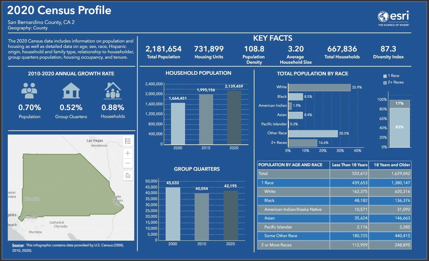
Users are also able to access DHC data through reports and infographics such as the 2020 Census Profile report and infographic:
Other Options for Accessing DHC Data Through Esri
Users who are interested in DHC data outside of the BA/GE environments can access the data in ArcGIS Living Atlas of the World and through the Esri Redistricting platform. The ArcGIS Living Atlas layers can be imported into Business Analyst to augment additional workflows. Additional information regarding the availability of DHC in ArcGIS Living Atlas of the World can be found in this blog.


Commenting is not enabled for this article.