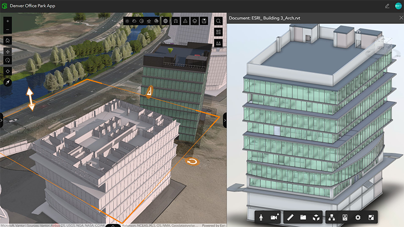
ArcGIS GeoBIM delivers a connected data environment that seamlessly links architecture, engineering, and construction (AEC) information in Autodesk Forma (formerly Autodesk Construction Cloud) with geospatial data and services in ArcGIS. By bringing these platforms together, teams can smoothly collaborate from initial design through operations to empower better decisions and project outcomes.
This release in ArcGIS Enterprise 12.1 delivers security enhancements to strengthen authorization permissions with Autodesk Forma. It also introduces key improvements to Autodesk Revit workflows, including georeferencing and default 3D view-based filtering, along with usability enhancements to the Document Explorer widget in ArcGIS Experience Builder.
Release highlights
Dive deeper into the latest capabilities now available in ArcGIS GeoBIM by visiting the product documentation and try them out for yourself. Have questions, feedback, or product ideas to share with our team? Visit and make a post in Esri Community today.
Autodesk authorization security enhancements
This release includes an updated Autodesk authorization experience that requests permissions more narrowly based on the workflow being used, enhancing the security of project data. Esri now requests read-only authorization for all standard workflows in ArcGIS GeoBIM and some ArcGIS Experience Builder widgets, including Document Explorer, Link Explorer, and Document Viewer.
When creating an Autodesk issue from ArcGIS GeoBIM Viewer apps or ArcGIS Field Maps, users grant a temporary ‘write’ authorization that is revoked immediately after the issue is created.
Expanded support for Revit workflows
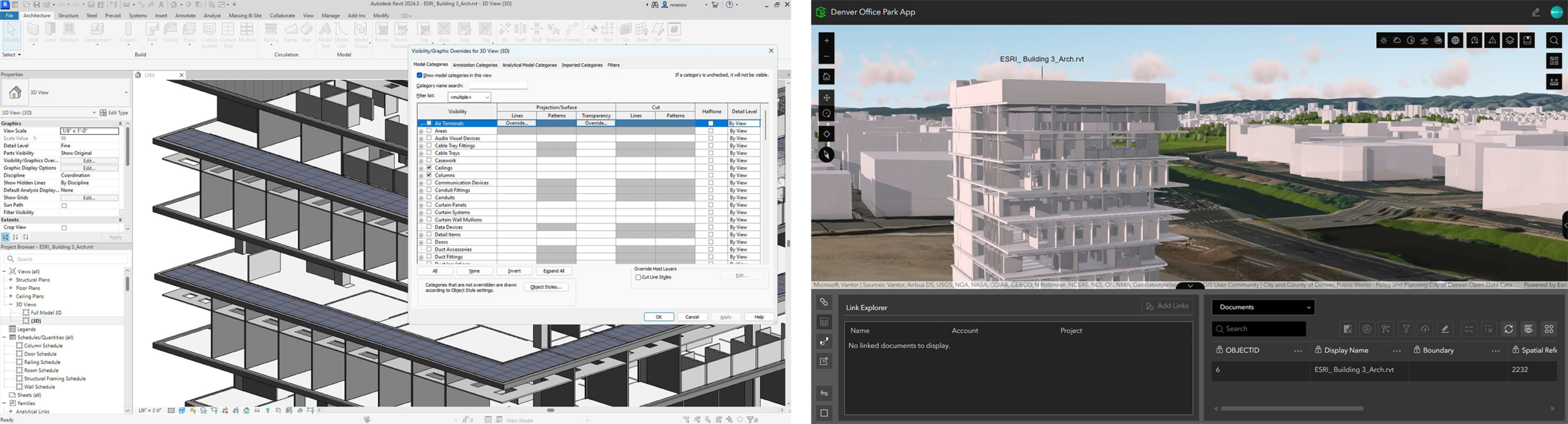
Revit default 3D view-based filtering
When running the Add Document Models tool, ArcGIS GeoBIM now uses the default 3D view of Autodesk Revit models to generate simplified geometry. This gives users greater control over the BIM data they bring into ArcGIS, resulting in a cleaner and more focused GIS experience.
Improved georeferencing of Revit models
ArcGIS GeoBIM now provides expanded support for georeferencing Autodesk Revit models by automatically recognizing internal coordinate systems (EPSG/WKID). This reduces manual effort and delivers more reliable, consistent spatial positioning across project data.
Support for Autodesk Revit 2026
This release of ArcGIS GeoBIM now supports Autodesk Revit 2026 files for 2D data. The Add Document Models tool, used to generate 3D simplified models, does not currently support Revit 2026 files at this time.
Enhancements to the Document Explorer widget in ArcGIS Experience Builder
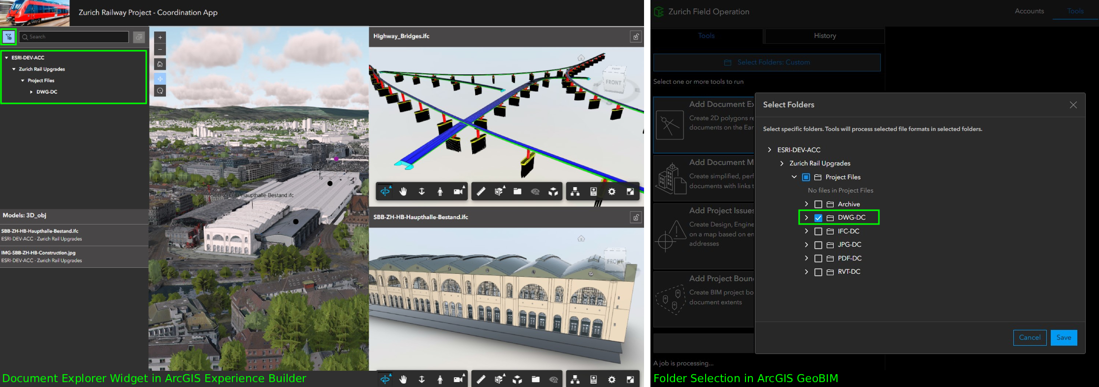
Filtered folder view
Users can now limit the folder tree to display only folders selected on the ArcGIS GeoBIM Tools page. This simplifies navigation in large Autodesk projects while preserving the ability to switch back to the full folder structure when needed.
Faster document search performance
Search results now return significantly faster, reducing delays when working with hundreds of project files. Project and folder ordering remain aligned with Autodesk Forma, helping users locate documents more responsively in enterprise environments.
Resources
Tutorial: Prepare your data for ArcGIS GeoBIM
Georeferencing your design files is a critical first step for integrating BIM and GIS. Doing so ensures that when these files are uploaded to Autodesk Construction Cloud and linked in ArcGIS GeoBIM, they align to the correct location on earth. This helpful guide provides a comprehensive, step-by-step approach to georeference CAD and BIM files entirely within Autodesk AutoCAD, Civil 3D, and Revit. It also covers setup, assigning a coordinate system, and three Revit workflows for establishing shared coordinates.
Learn how to georeference your data
Get started with ArcGIS GeoBIM tutorial series
If you’re new to using ArcGIS GeoBIM, start learning the basics of preparing your data to create and share your first project and app. Then, advance your skills to collect, monitor, and address project issues with office to field collaboration. With four tutorials series that build on each other, you’ll also find learning content for extending ArcGIS GeoBIM as a system to build custom apps, tailor 3D scenes, and work with schedules.
Take the next step
If you’re using ArcGIS Enterprise 11.4 or higher, you can access ArcGIS GeoBIM as an included app with a Contributor user type or above. To begin creating ArcGIS GeoBIM projects and apps, you’ll need at least one Creator, Professional, or Professional Plus user type along with Autodesk licensing.
There are many reasons to upgrade to the next generation of ArcGIS Enterprise. Discover what’s new in ArcGIS Enterprise 12.1 for an overview of the exciting enhancements and powerful geospatial capabilities included to support your work.





Article Discussion: