
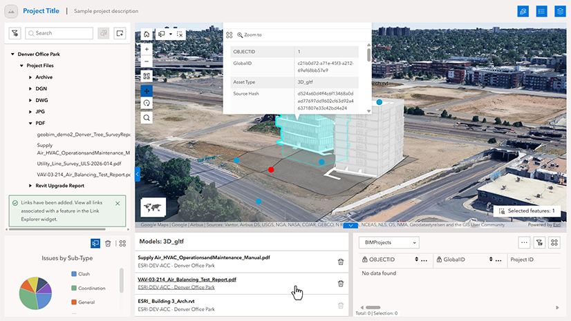
ArcGIS GeoBIM delivers a connected data environment that seamlessly links architecture, engineering, and construction (AEC) information in Autodesk Forma (formerly Autodesk Construction Cloud) with geospatial data and services in ArcGIS. By bringing these platforms together, teams can smoothly collaborate from initial design through operations to empower better decisions and project outcomes.
This release in ArcGIS Enterprise 12.2 enhances BIM-to-ArcGIS workflows with Autodesk Forma by giving teams greater control over how BIM data is synced for use in ArcGIS. With improvements for filtering Autodesk Revit models, post-sync diagnostics, and georeferencing of Industry Foundation Classes (IFC) files, teams can improve data quality, reduce rework and coordinate more efficiently to keep projects moving forward.
Release highlights
Visit the product documentation for more details on the latest enhancements now available in ArcGIS GeoBIM. Visit Esri Community to ask questions, share feedback, or submit product ideas.
Revit named 3D view-based filtering
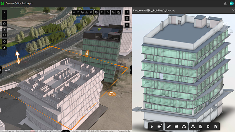
ArcGIS GeoBIM now supports syncing Autodesk Revit models using a dedicated 3D view named “3D ArcGIS” when running the Add Document Models tool. This enables users to control which families and categories are included by syncing only the content visible in that view.
By using a purpose-built, ArcGIS-ready view, teams can create cleaner, more focused simplified 3D models that highlight the most relevant project information. This improves processing speed and enables better collaboration across BIM and GIS teams.
Create a “3D ArcGIS” view in Revit and publish it to Autodesk Forma to define what model content is synced. The Add Document Models tool in ArcGIS GeoBIM then uses this view to produce a filtered, simplified 3D model.
An informed and reliable syncing experience
ArcGIS GeoBIM introduces several enhancements that give teams greater visibility and confidence throughout the syncing process. New analysis reports help users identify data issues before synchronization and understand errors afterward.
Pre-sync analysis report
ArcGIS GeoBIM now provides a pre-sync analysis report that helps users assess whether project documents are spatially ready before running the syncing tools. The report reviews georeferencing and coordinate system information, then highlights missing or incomplete information and provides resources to help resolve it.
By identifying potential issues before synchronization begins, teams can prepare project data with greater confidence, prevent avoidable sync failures, and reduce the rework and delays associated with troubleshooting problems later in the workflow.
Run a pre-sync analysis in ArcGIS GeoBIM to identify which project documents are GIS-ready, which require attention, and how to resolve potential issues before syncing with Autodesk Forma.
Post-sync error report
In addition to the pre-sync report, ArcGIS GeoBIM provides a dedicated post-sync error report that clearly explains why a sync failed or completed with errors. The report brings job errors together in one place, identifies issues related the syncing process, and connects users with relevant troubleshooting resources.
This gives teams clearer, more actionable feedback after synchronization, helping them identify the source of an issue, involve the appropriate team members, and resolve problems faster. By reducing uncertainty and rework, teams can keep project data and coordination moving between BIM and ArcGIS workflows.
Improved georeferencing of IFC files
ArcGIS GeoBIM now provides more consistent georeferencing and placement for IFC models by more reliably interpreting location information across different IFC versions.
This makes IFC handoffs into GIS more predictable and reduces the risk of misplaced models and processing failures. BIM and GIS teams can sync and align project data with greater confidence, reducing manual corrections and rework.
Support for Autodesk Revit 2026 and 2027
ArcGIS GeoBIM now supports working with Revit 2026 and 2027 models in both 2D and 3D views. This release expands support for Revit 2026 models, introduced in ArcGIS Enterprise 12.1 for 2D views, by adding 3D support and introducing full support for Revit 2027.
Discover more
Get started with ArcGIS GeoBIM tutorial series
If you’re new to using ArcGIS GeoBIM, start learning the basics of preparing your data to create and share your first project and app. Then, advance your skills to collect, monitor, and address project issues with office to field collaboration. With four tutorial series that build on each other, you’ll also find learning content for extending ArcGIS GeoBIM as a system to build custom apps, tailor 3D scenes, and work with schedules.
Tutorial: Prepare your data for ArcGIS GeoBIM
Georeferencing your design files is a critical first step for integrating BIM and ArcGIS. Doing so ensures that when these files are uploaded to Autodesk Construction Cloud and linked in ArcGIS GeoBIM, they align to the correct location on Earth. This helpful guide provides a comprehensive, step-by-step approach to georeference CAD and BIM files entirely within Autodesk AutoCAD, Civil 3D, and Revit. It also covers setup, assigning a coordinate system, and three Revit workflows for establishing shared coordinates.
Learn how to georeference your data
Get started
With a Contributor user type or above, you can view and contribute to ArcGIS GeoBIM projects that have been shared with you in ArcGIS Online and ArcGIS Enterprise 11.4 and higher. To create new ArcGIS GeoBIM projects, you’ll need a Creator, Professional, or Professional Plus user type, along with licensing for Autodesk Forma.



Article Discussion: