Do you expend more energy daydreaming about all the places you could go, or wordly adventures you could have, than you do making those daydreams a reality? It’s perfectly normal, and you’re not alone.
Even when there isn’t a global pandemic thwarting our best laid plans, coming up with the time and money to indulge our loose-footed instincts can still be tricky. While it’s certainly not the same as putting your boots on the ground, mental escapes can still be healthy and productive. Luckily, with ArcGIS StoryMaps, there’s a ready-made platform to channel your vicarious wanderings into tangible content.
In this article we’ll outline three great ways to “travel virtually” using the combination of writing, multimedia, and mapping offered by ArcGIS StoryMaps.
Write a travelogue about a trip you’ve already taken
In the absence of being able to embark on new adventures, sometimes looking back at past ones can be the next best thing. One of our favorite uses of ArcGIS StoryMaps is the travelogue, a narrative relating the storyteller’s own experience in unfamiliar territory.
One trick to writing an effective, memorable travelogue is to do more than merely say you went to places A, B, and C, where you did X, Y, and Z. The best travel writing creates an emotional connection with its readers. How did your experience make you feel? What sentimental responses did it spark? What kinds of people did you interact with, what were those interactions like, and how did they change the way you think about that place?
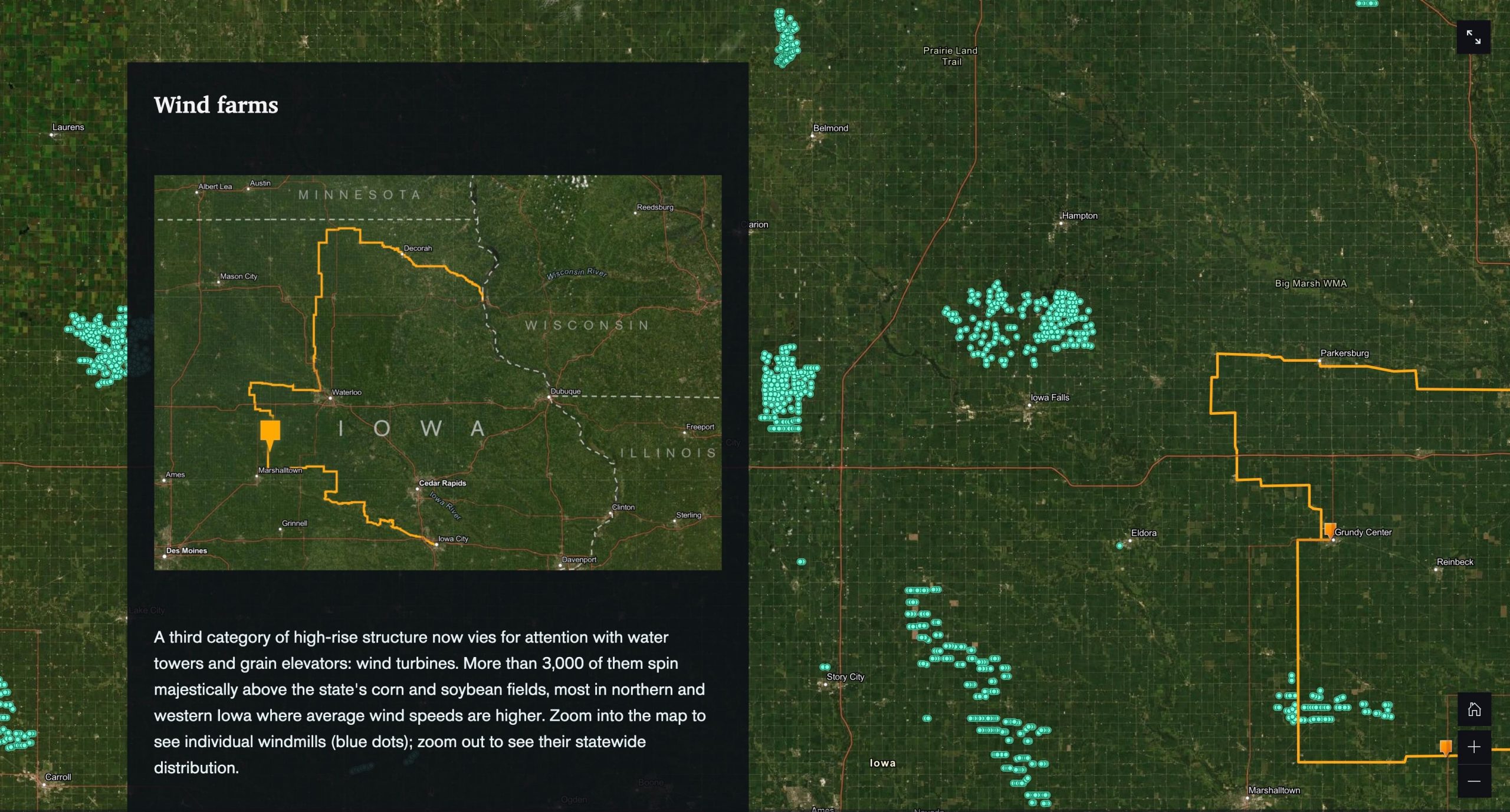
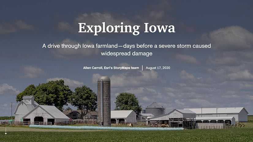
Don’t be shy about weaving the bigger picture into your story, either. Anecdotes and asides about a place’s history, its livelihoods and reasons for existing, noteworthy things that may have happened there, its connections to art, literature, or pop culture—these all help to further immerse a reader into that place. In this blog article, Allen Carroll offers advice on how to take advantage of ArcGIS StoryMaps’ cartographic capabilities to find and visualize geographic data that can give your travelogue enhanced context.
Another key to travel writing is determining how to work in images and other media. There is no hard and fast rule; some writers prefer to let their words do most of the heavy lifting, while others devote more of the limelight to accompanying photography.
ArcGIS StoryMaps provides plenty of flexibility when it comes to incorporating media. Storytellers can intersperse single images throughout their text, create immersive multimedia experiences via sidecar and map tour blocks, or present an whole array of images via a slideshow or the another ArcGIS StoryMaps feature: image gallery. To help your travel stories really stand out, Hannah Wilber has written an entire blog devoted to best practices when it comes to visual storytelling.
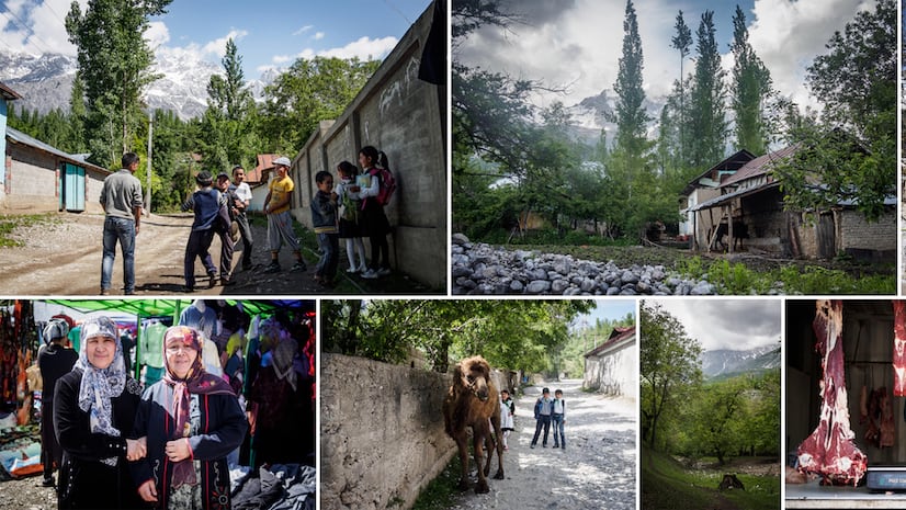
For a superb example of how ArcGIS StoryMaps can be utilized to tell a captivating travel story, check out this chronicle of a road trip in Kyrgyzstan by Cooper Thomas. More travel memories can be found in the #TakeMeBack collection, featuring entries by the StoryMaps team and members of the ArcGIS StoryMaps community. If you want to show off a travel story you’ve put together using ArcGIS StoryMaps, tweet @ArcGISStoryMaps with the hashtag #TakeMeBack—we may even add your story to the collection!

Produce a guide to a place you’re fond of
Sometimes the easiest way to mentally escape is by living vicariously through someone else—particularly by helping them experience a place near and dear to you through fresh eyes. Who doesn’t relish the opportunity to show a visiting friend or loved one around your favorite haunts? Or derive satisfaction from seeing someone else enjoy an activity you’ve always enjoyed yourself?
ArcGIS StoryMaps is the perfect medium for putting together an electronic guidebook that can fit in the palm of anyone’s hand, via their smartphone. With ArcGIS StoryMaps, you can share your hard-earned knowledge about a place and encourage others to come explore it, when the opportunity arises.
The beauty of travel guides is that they don’t need to be exhaustive, as the popularity of the New York Times’ “36 hours in…” series has shown, for instance. The sweet spot is to give readers enough options that they feel some degree of autonomy in picking out the destinations, attractions, and eateries that suit them, while not overwhelming them with what can feel like impossibly infinite choice.
When writing a travel guide, grouping points of interest together logically is one strategy to reduce the risk of information overload. Organizing potential stops geographically or by theme are two common-sense ways that work well.
In this guide, the StoryMaps team’s Will Hackney recommends weekend destinations for residents of, or longer-term visitors to, the Washington, D.C. metro area.

Create an itinerary for your next trip
Finally, it never hurts to put your most ambitious plans down on (virtual) paper. After all, it’s one small step closer to making them come to fruition! Devise an itinerary for a dream vacation and use ArcGIS StoryMaps to bring it to life.
Even if you start with a vague idea (“It would be fun to drive from Point A to Point B some day…”), researching and filling in the blanks can be an invigorating and inspirational rabbit hole. You can be as specific or as generalized as you like when answering questions such as: What would you like to see? Where will you stay? What will you eat?
Given that you’re likely writing about a place to which you have not been, you probably won’t have your own photographs to show off. You’re still highly encouraged to go out and find pictures to add visual flavor, but you’ll need to be careful about where you’re getting those photos from.
The safest thing to do is make sure that any visual asset you’re using is either in the public domain or licensed under Creative Commons. Most of the images on Wikipedia, for instance, fall under either of those two categories. Many photo-hosting sites, such as Flickr, offer ways to search only for photos that are Creative Commons licensed. When in doubt, find a different photo to use. And regardless of the source, always add attribution for any media that doesn’t belong to you!
In her itinerary for a someday castle tour of Scotland, StoryMaps team content creator Hannah Wilber takes note of important logistical information about each stop on her must-see list, while aggregating a few nearby activities she’d like to check out in the area, time permitting.

With these ideas and tips in mind, you should be ready to dive into the ArcGIS StoryMaps builder and tell gorgeous stories about the interesting places you’ve been or want to go. For guidance in getting the most out of ArcGIS StoryMaps’ many features, our resources page is a good place to start. Specific questions can be directed to the Esri Community page for ArcGIS StoryMaps.
We hope to see you—virtually—in a far-off locale soon!


Article Discussion: