The ArcGIS Survey123 February 2022 update is now available. This release includes great additions to the Survey123 web designer to help you visually create more powerful smart forms. The Survey123 field app includes massive improvements to make calculations faster and support for custom markup tools. All of that, and much more!
Read on to learn what’s new:
Survey123 web designer and web app
- Use your own web maps in a survey
- Have your survey automatically get the respondent’s location
- Use your own locators with the address and map questions
Survey123 Connect and field app:
- Faster calculations and new calculation modes
- Markup photos, maps and diagrams with custom markup tool palettes
- New Media tab and Overview folder option
Other enhancements and important release notes:
Survey123 web designer and web app
The Survey123 web designer helps you visually create smart forms, right from a web browser. In recent updates we added support for the new Address question type, introduced calculations, and added options to permanently hide questions in your form.
This release brings more enhancements to the Map and Address question types.
Use your own web maps in a survey
Up until this release, you could configure a default map for your survey. Well, kind of, as you could only choose a map already present in your organization’s basemap gallery. Now, however, you can select any web map!
Note that a new Edit option has been added to help you configure the contents of your map. You can select a map you own as well as other maps from your organization.
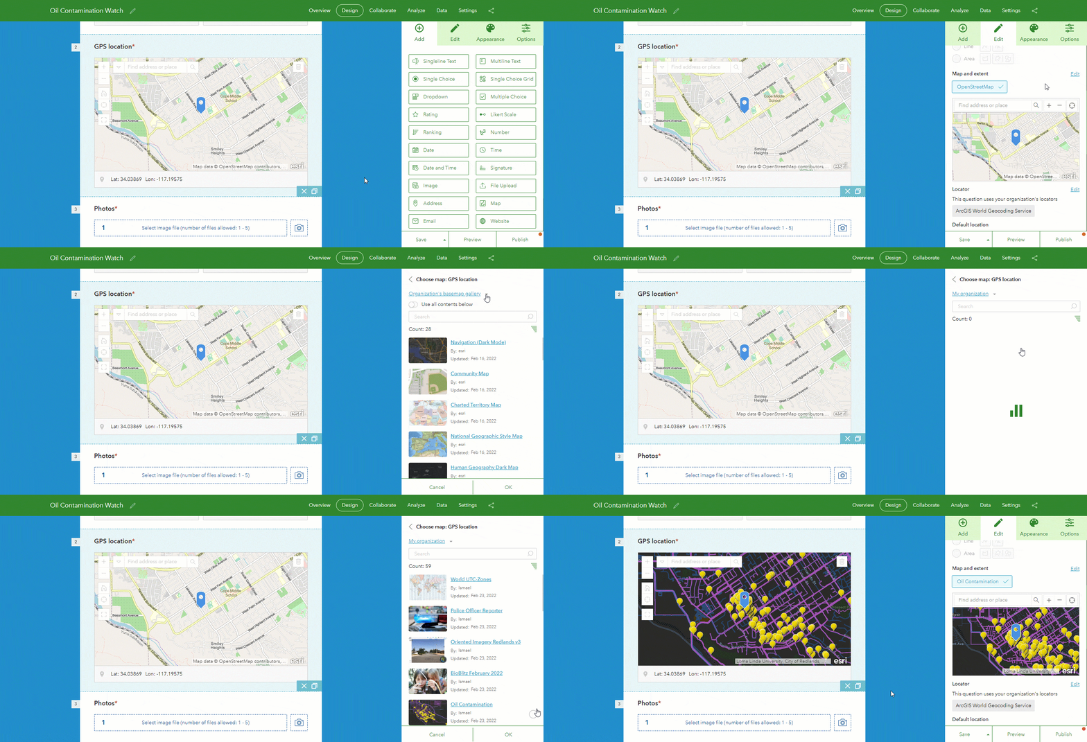
Have your survey automatically get the respondent’s location
Map questions now support various options to determine the default location. Use these options to specify the behavior of your map: Should the map automatically center when the survey is opened? Or when the user interacts with the map? What if instead the map should be centered at a predetermined location?
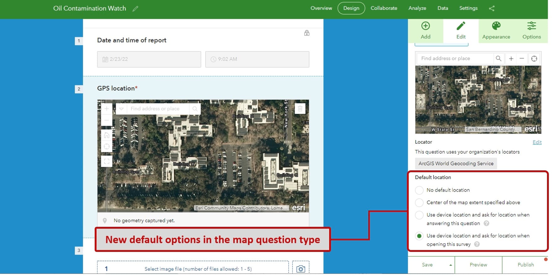
Automatically centering the map when the form loads is something new for online surveys. Combined with calculations, it is a powerful option because it makes your smart forms location-aware.
Say, for example, you create a survey to report issues in your city. Since you know where the user is, you can automatically populate questions such as city, postal code or address where the incident happens.
Use your own locators with the address and map questions
Many people may not know how to pinpoint the location of something in a map, but for sure they will now its address. We introduced the address question type in our previous release. It helps respondents complete an address as they type.
To simplify data entry boost the quality of your data, it is good practice to configure address questions with your own locators. You can now easily do that right from the Survey123 designer.
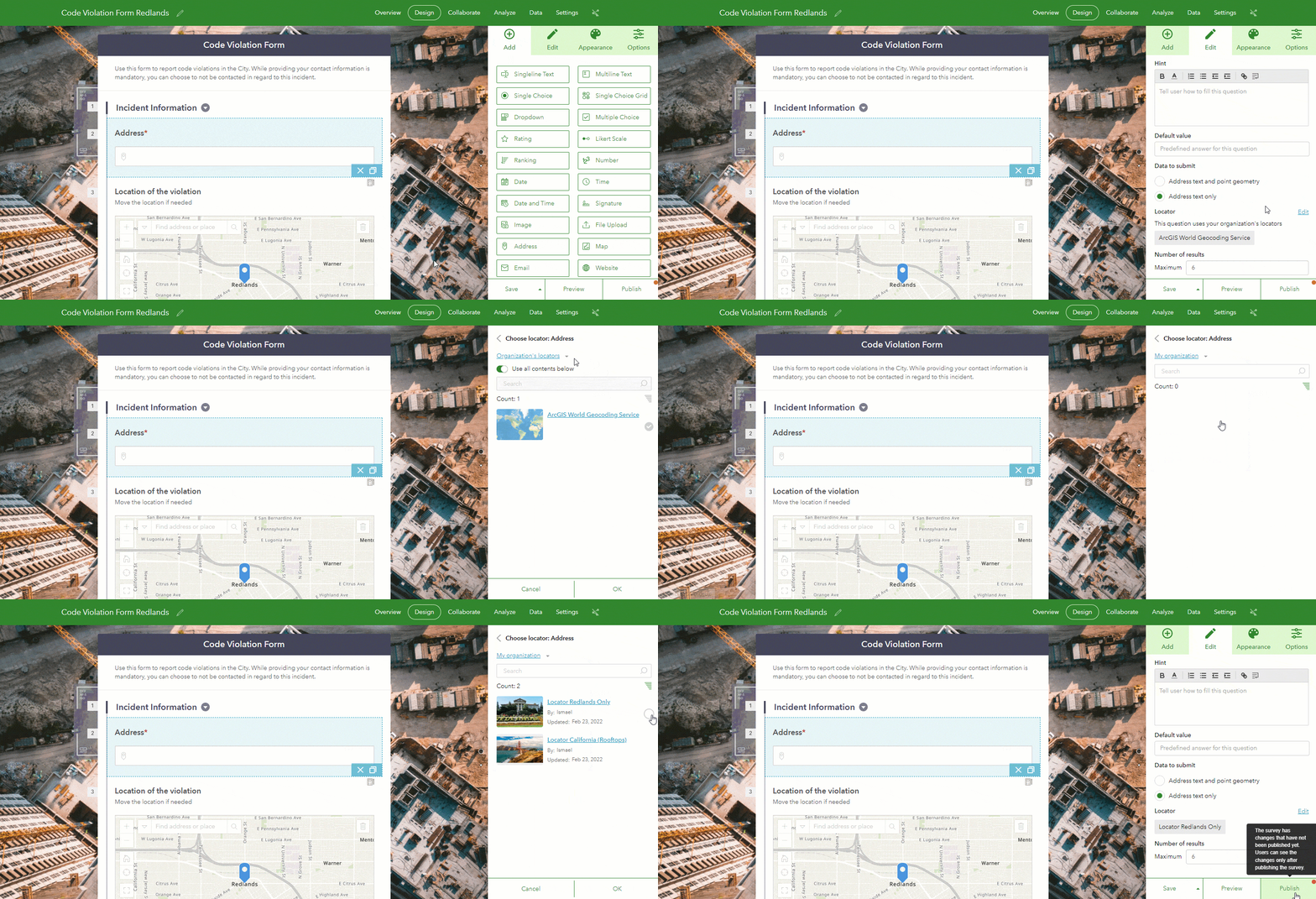
If you are creating a web survey to collect information in your city, why would you use a locator with addresses from other places? Learn how to create your own locator, share it, and use it with your Survey123 address questions.
Survey123 Connect and field app
Survey123 Connect is a desktop tool. With it, you can author the most sophisticated forms using an XLSForm spreadsheet. The Survey123 field app is available for iOS, Android and Windows devices. It includes advanced options to work with your smart forms from the field, or the office.
The new build numbers for Survey123 Connect and the field app are 3.14.256 and 3.14.237, respectively.
Faster calculations and new calculation modes
Calculations in a smart form allow you to populate questions based on previously entered responses. The calculation execution in the Survey123 field app has been optimized to make your forms faster. You will appreciate the difference when working with very large forms.
Additionally, starting with this release, you can specify three different calculation modes in your questions:
- Auto: The calculation is triggered if the question is empty or if it has not been previously modified by the user. This is the default mode and the only one available up until this release.
- Always: Auto-calculates the value, even if the user has already entered a value.
- Manual: Use this option if you want the user to trigger the calculation manually.
The new calculation modes give you more flexibility to dictate the logic of your form.
Markup photos, maps and diagrams with custom markup tool palettes
Survey123 includes image annotation tools. With them, users can markup photos, diagrams and maps. We gave these tools an overhaul in late 2021. This update introduces the concept of custom annotation tool palettes.
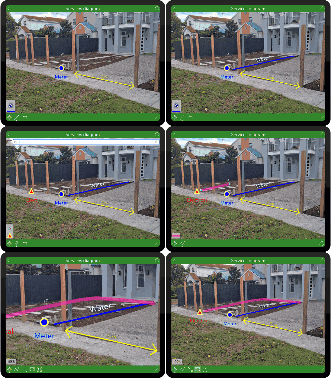
While Survey123 comes with its own annotation tools, you may want to tailor the user experience, so it best fits your workflows. For example, if you are supporting an effort where you know users will markup in a photo the location of existing water and gas meters, you will want to create markup tools for these two features, and nothing else.
Below are some examples of custom annotation tool palettes. Note that each of the tools has its own meaning. They are all categorized logically into separate groups.
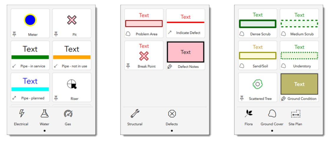
Custom annotation tools make image markup more intuitive, but they also help generate more consistent image annotations.
Find more about custom annotation tools, in our documentation and this blog post.
New media tab and overview folder option
Use the new Media tab in Survey123 Connect to quickly visualize the contents of the media folder for your survey, such as CSV files, custom annotation palettes, audio files and images.
On the Options tab, you will find a new switcher to enable or disable the Overview folder. The Overview folder is useful when you want users of the Survey123 field app to view all survey records in a single map or list.
Other enhancements and important notes
Improved report syntax
Use new report syntax to display multiple records on a single map. You can also rotate photos!
Other release notes
As announced in May 2021, macOS installers for Survey123 Connect and Survey123 field app are no longer available with version 3.14.
Access to the Survey123 field app and Connect source code in ArcGIS AppStudio is now available only upon request. Complete this form if you would like access.
The next updates are planned for March 2022 and April 2022. If you want to get up to speed on new features coming, join the Survey123 Early Adopter Community.


Commenting is not enabled for this article.