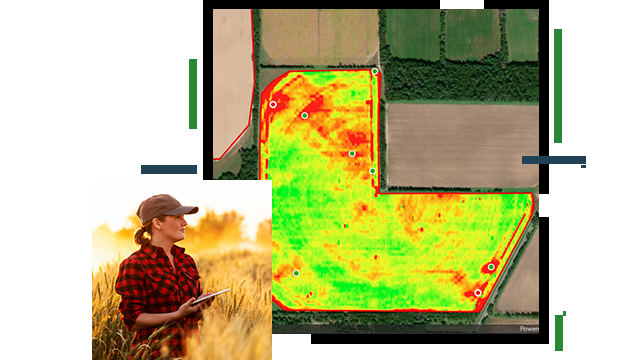
Skip to Content

Mobile Work and Connectivity

Leverage technology in an integrated system

A composite aerial photo of a segmented field layered with a heat map, overlaid with a photo of a person standing in a field of wheat holding a tablet

Assign tasks and monitor mobile work in real time

Smart agribusiness companies are making field operation more efficient with GIS. Collecting data, often remotely, and analyzing it in near real time with performance dashboards help leaders model complex workflows, accelerate response times, eliminate waste, and reduce costs. Use location technology to balance and guide input resources more precisely while improving quality and customer satisfaction.

Integrate complex mobile work

Field operations

Use integrated field apps to collect detailed information at the source, often remotely. Enable a combination of form fills, rapid observation collection, and Internet of Things (IoT) sensor data to create a foundation of current field knowledge that improves awareness.

A photo of a farmer standing in a field of long rows of green crops, leaning over to take a closeup picture of one of the plants

Location tracking

Coordinate, schedule, and dispatch workforce activities efficiently. Assign tasks, monitor status, and measure progress in real time to increase productivity throughout each step of the supply chain.

A photo of a big rig driving on a sunny highway towing several open-top trailers full of onions

Real-time visualization and analytics

Strengthen precision agriculture workflows. Collect and analyze information in a near real-time performance dashboard to model complex workflows, improve response times, eliminate waste, and reduce costs. 

A graphic of a computer monitor displaying a map dashboard with a map of green farmland, a graph, and vegetation statistics

ARTICLE

Land O'Lakes uses GIS to manage strategic assets

Land O'Lakes streamlines the quality, consistency, marketing, and economics of the farms' dairy products.

Go to the article

Products for mobile work and connectivity

These collections of products and solutions help staff visualize and collect data from the field.

Previous
Next

Contact sales

Contact us

Outside the United States

Connect with the Esri agriculture team