Develop partnerships to solve food security challenges
Provide global food security by 2050
Feeding a population that could reach 10 billion by 2050 is an enormous challenge. Food producers must balance growing more crops with higher nutritional quality while minimizing environmental impacts related to soil resources, water consumption, and CO2 emissions. Producers must dramatically scale sustainable practices, which will require connecting smart farm leadership with policy makers at state and national levels through new business models.
Ensure long-term food and economic security
Spatial analysis
Field operations
Real-time events processing
Imagery and remote sensing
Spatial analysis and data science
Spatial technologies and data science must be improved through active research to create broader ranging positive influence at scale.
Field operations
Field operations must become much more efficient, which implies more automation and digitally supported precision farming.
IoT and real-time events processing
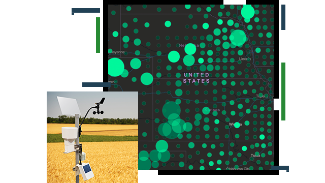
The Internet of Things (IoT) will become critical to understanding current production status and move closer toward predictive analytical models.
Imagery and remote sensing
GIS imagery and remote sensing will become critical to agriculture management by detecting change through multitemporal datasets and imagery in real time at scale.
CASE STUDY
Florida maps support farmers during COVID-19
Leaders in Florida are using GIS to connect potential buyers with farmers and producers of Florida-grown commodities.
Go to the case study
CASE STUDY
Map-based apps fight food insecurity
During the COVID-19 pandemic, the State of Indiana created a GIS application to connect residents to nearby food pantries, meal sites, and schools.
Go to the case study
INTERACTIVE MAP
Accelerating agricultural research
The US Department of Agriculture's (USDA) Partnerships for Data Innovations team is improving data accessibility, analysis, and visualization.
Explore the map
INTERACTIVE MAP
Global Agricultural & Disaster Assessment System
A web-based app combines near real-time Earth observation data and GIS tools to monitor crop condition and assess postdisaster impacts.
Explore the map
INTERACTIVE MAP
AgCROS Networks
Explore a map and website with data and data resources on USDA Agricultural Research Service (ARS) natural resources, genomics, and nutrition efforts.