The humanitarian sector has entered a more resource-constrained era while crises grow more complex. That tension is accelerating (and forcing) a long-sought-after reset: stronger local and national ownership; clearer accountability to communities; and operational models that hold up when funding, staffing, and access are disrupted. In fact, across conversations at the Humanitarian Networks and Partnerships Weeks (HNPW) in Geneva this year and our most recent GIS for Good meetup, there was clear recognition that more resilient, accountable, and coordinated humanitarian systems depend on national ownership, interoperable infrastructure, and better integration across local, national, and international actors.
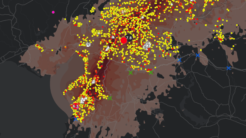
Humanitarian response and Disaster Risk Management are inherently geographic problems. Vulnerability concentrates in specific places, as exposure and coping capacity are unevenly distributed across landscapes. If we want humanitarian response, disaster risk reduction (DRR), and resilience-building efforts to be more effective, our systems need to reflect the spatial reality of how risk is experienced.
That’s why we’re launching a blog series focused on how geographic information system (GIS) technology and integrated geospatial infrastructures can help humanitarian and DRR actors build more connected, locally owned, and resilient ways of working.
Topics include:
- From Top-Down Systems to a Local–National Mesh
Building a future on distributed capacity, stronger national frameworks, and local ownership in partnership with larger organizations - GIS, Risk, and the Triple Nexus
Moving beyond fragmented information systems toward shared operational pictures that support humanitarian, development, and peace-building actors working toward common goals - Building National Geospatial Capacity for Disaster Risk Management
What does it look like to strengthen national disaster management authorities (NDMAs) with geospatial strategy, sustainable data access, and communities of practice?
Who Should Follow This Series
This series is for humanitarian and DRR practitioners and decision-makers navigating localization, national capacity building, coordination, and resilience:
- National disaster management authorities and technical ministries
- United Nations agencies, international nongovernmental organizations (INGOs), and local nongovernment organizations (NGOs)
- Data/Information management (IM) and GIS teams supporting operational planning and response
- Donors, foundations, and partners focused on durable systems and accountability
If you’re trying to connect field data to decision-making, align partners around shared priorities, or move from just maps to integrated operational workflows, you’ll find usable ideas here.