Improving Planning Processes and Creating an Overview for the Reconstruction and Rebuilding of Infrastructure in the Ahr Valley
By Elena Krupp (Berthold Becker GmbH), Markus Becker (Berthold Becker GmbH), Ole Seidel (alta4 AG)
Introduction
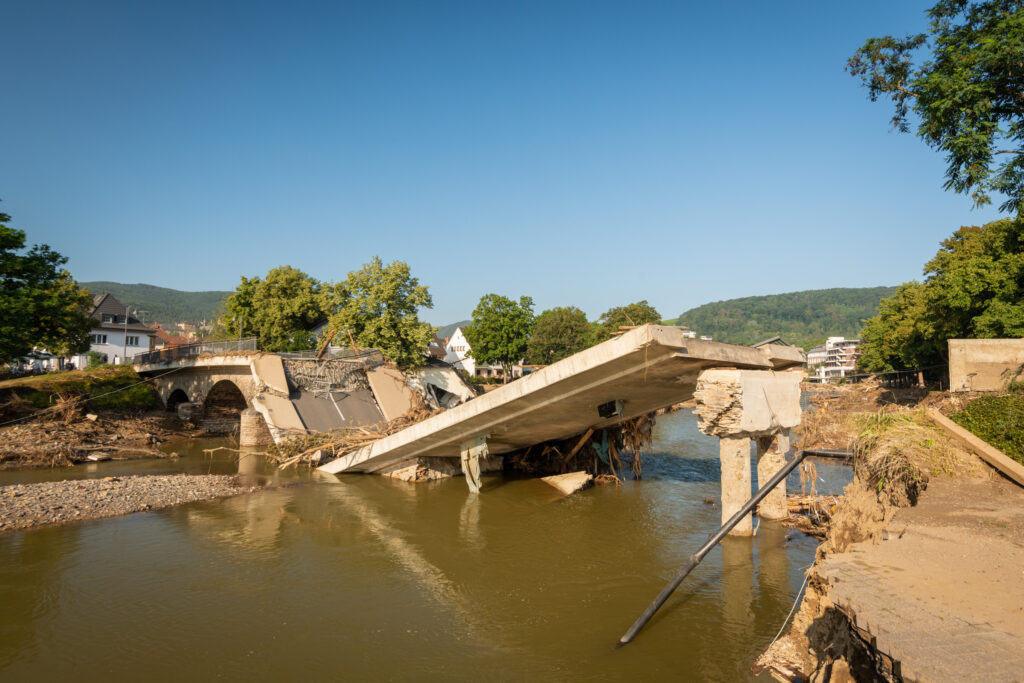
During the flood disaster in the Ahr valley in July 2021, unprecedented amounts of rainfall were recorded, which led to an extreme rise in water levels. In some areas, more than 150 liters of rain per square meter were measured. The discharge of the rivers in the Ahr valley reached record levels, causing the flooded areas to continue to grow. The prolonged rainfall caused the water level to rise further and further, so that entire villages literally sank under the masses of water. Houses, bridges, and roads were washed away, and the infrastructure of the affected areas was severely damaged or destroyed. Initial estimates put the cost of the damage at billions of euros. Unfortunately, the flood disaster also claimed many lives and some people are still missing. Thousands of people lost their homes and had to be evacuated. The flood disaster in the Ahr valley in July 2021 was one of the worst natural disasters in Germany.
Berthold Becker GmbH has been providing sustainable infrastructure in Rhineland-Palatinate and North Rhine-Westphalia for more than 50 years. To this end, we develop innovative solutions for our customers at our engineering office in Bad Neuenahr-Ahrweiler. As experts in the field of municipal civil engineering and road construction, we combine traditional engineering services with new ideas and techniques to develop sustainable infrastructure systems in the areas of road construction, water supply, and wastewater disposal. Flood and heavy rainfall prevention are also becoming increasingly important issues that we are addressing. The company is based in Heimersheim, a district of Bad Neuenahr-Ahrweiler. Parts of Heimersheim were also affected by the flood. Some of our employees and their families were also privately affected by the events. Due to our local knowledge and years of experience in infrastructure projects in the region, it was clear that our infrastructure team could make a major contribution to reconstruction.
Challenge
It’s a difficult task to organize all the reconstruction and rebuilding measures. Currently, there is no overview of all the reconstruction measures in the Ahr valley. One of the tasks is to maintain an overview of the various parties involved in planning and to network the stakeholders/clients and planners with each other in a meaningful way. Various players work in parallel on the planning for the respective trades and often collisions between the different trades only become known once the construction site has already been set up.
To recognize and evaluate interrelationships, we need clarity and a general survey. We want to create a tool for all actors in the municipal infrastructure sector. Especially nowadays, when there is so much insecurity in the public about the topic of the best reconstruction of the Ahr valley region, it’s important to communicate with all citizens that reconstruction is being worked on step-by-step and in a holistic way.
The citizens’ demands for reconstruction are countered by financial demands. Many of the initiatives are funded by the state but must comply with funding guidelines and some infrastructure measures. Approval procedures must also be carried out before construction. Citizens, on the other hand, want reconstruction to be quick and unbureaucratic. Good planning and the necessary steps for funding and approval of the projects take time, so clear and open communication is crucial.
Solution
To address these challenges, we decided to start the “Ahr Valley working model” with the collaboration of the company alta4. ArcGIS technology was used to create a working model consisting of maps and visualizations in 3D, as well as interactive story maps. Different data of different actors has been collected and combined in the working model.
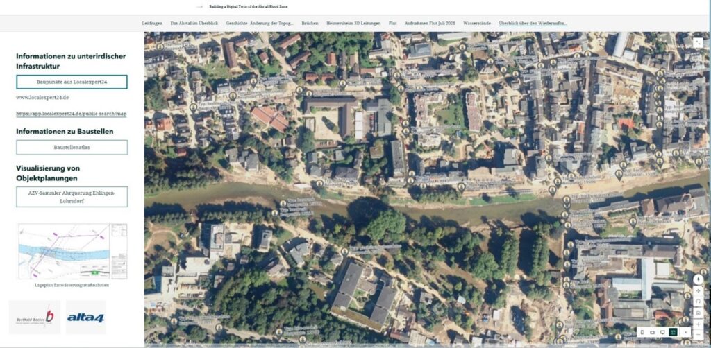
Components of the working model are, for example:
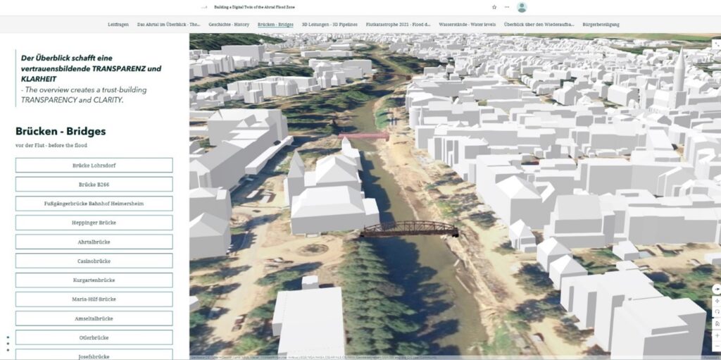
- Models of bridges destroyed by the flood
- Terrain Model Data
- LOD2 data of the buildings
- 3D infrastructure planning
- Flood hazard maps
- Images from private sources
- Historical maps
- Aerial photography
- Database of the underground sewer system
One component of the working model is focused on bridges. Around 100 bridges have been destroyed by the flood. The process for modeling bridges utilizes information from old 2D plans.
The terrain model is based on laserscan data from the company Planning Plus, located in Bad Neuenahr-Ahrweiler. When recording a terrain model using laser scanning and a drone, the terrain is measured with a laser beam and the data is recorded by the drone from an elevated position. This method enables the terrain to be captured quickly and precisely and a detailed 3D model to be generated for various applications such as mapping, construction planning, or terrain analysis. Laserscan data was taken after the flood and shows the enormous changes of the riverbank after the flood. In some places, the riverbed has shifted considerably.
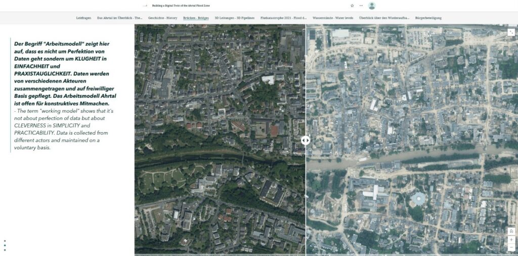
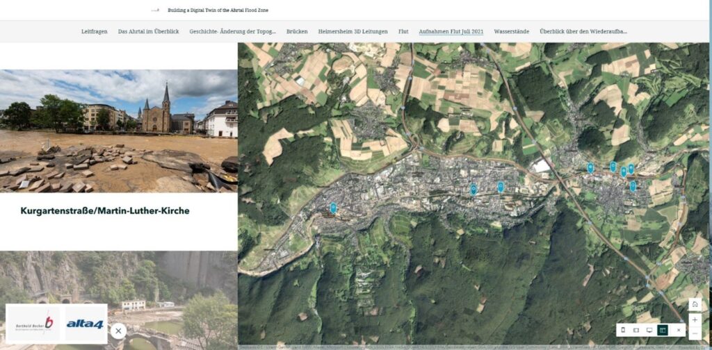
Another feature of the model is the ability to compare orthophotos from before and after the natural disaster in 2021. The tool consists of the aerial image before the flood and the image after the flood, which can be superimposed using a slider. This makes it possible to directly evaluate the effects of the flood disaster on the area. This makes it feasible for everyone to observe the extent of the event.
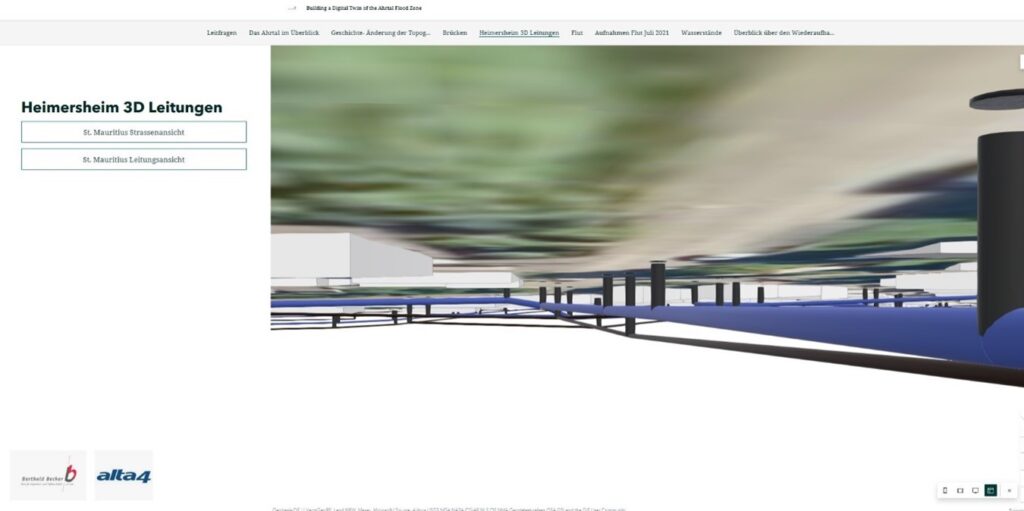
Additionally, the working model provides the ability to visualize underground infrastructure. The underground infrastructure database includes information about locations, depths, and dimensions. We visualize the sewer network, sewer network planning, and various special structures from wastewater technology. 3D elements were derived from the line information in the sewer database and linked to the 3D plans of the structures.
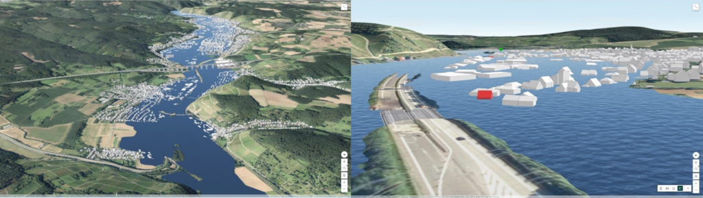
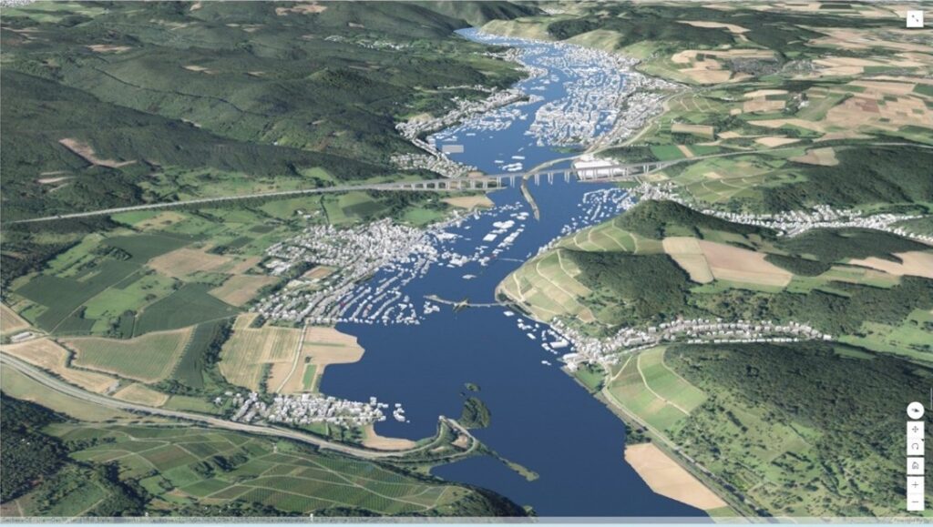
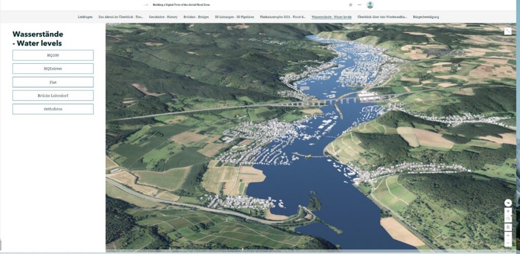
Lastly, the working model includes the ability to visualize the water level in the Ahr valley. The water level in 2021 was much higher than anyone could imagine. The reconstructed water level is visualized in a 3D layer. For this purpose, a layer was created on the basis of a documented flood line (2D), which was intersected with the terrain model. This area was transformed into a 3D area based on the intersection points with the terrain model. Additional water levels of an event occurring statistically every 100 years is visualized, too. By visualizing the water levels, it becomes clear what extent the event had and what consternation it had caused.
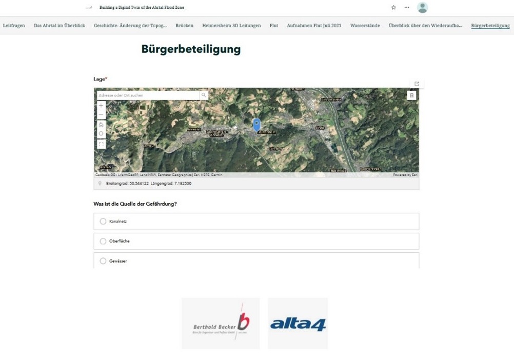
Through the integration of a survey, citizens have the opportunity to participate and share their information and knowledge of danger points and previous events. The collection of information and images is important in order to build up an “infrastructure memory”. The experiences from the flood must not be forgotten after two generations, but must be saved and passed on. They also can propose measures to be improved in the reconstruction process. We used ArcGIS Survey123 to create a smart form for collecting data via mobile devices, therefore making it easy to understand for everyone.
Results
The working model represents a digital infrastructure memory. It helps to permanently record interrelationships and contributes to disaster protection. The benefits of the working model are:
- Complex interrelationships become visible and understandable through 3D visualization.
- Improved collaboration between departments supporting reconstruction efforts.
- Model-based planning and building is promoted.
- Additional information about underground infrastructure and construction projects is acquired by connecting multiple platforms.
- Not only can citizens share their information and knowledge, they can also easily access and visualize reconstruction plans.
In addition to information about historical development of the riverbed, the working model contains information about infrastructure, damages, and reconstruction. This overview creates trust-building transparency and clarity. There is no claim to perfection or completeness, but the aim is to create a simple and practical tool for planning processes. This low-threshold access for experts, and for local politicians and citizens, shows the benefit of information technology.
About the author