Round Rock, Texas, is a community of more than 130,000 residents and is located just north of Austin. Known for its award-winning park system and public safety, the city government has earned multiple statewide municipal excellence awards for public safety and public works. Despite these achievements, Round Rock faced challenges with its permitting system. City officials relied on an outdated, paper-based system that required applicants to visit the office in person to submit forms and payments. The city already used Trimble solutions for its asset management workflows, and in 2023, it adopted Trimble Cityworks PLL, built on Esri® ArcGIS® software, to digitize and streamline the permitting process.
In the Past
The manual, paper- and email-based processes the City of Round Rock used for permitting consumed copious amounts of paper and time. For example, issuing a parade permit involved emailing a PDF to several departments and compiling comments and changes—a process that was slow and prone to inefficiencies. Every payment transaction had to be completed in person, in the office. Administrators spent long hours entering data into software, taking them away from important duties such as customer assistance and intake.
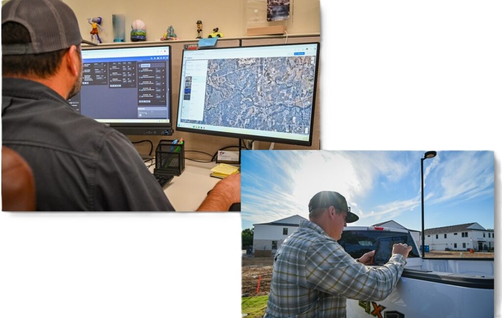
The government wanted to modernize its permitting and inspection workflows, allowing contractors and property owners to submit documents from the field instead of coming to the office with a piece of paper. “We wanted to become more effective and efficient with how we do things,” says Nathan Smith, Geospatial Services Manager for the City of Round Rock. “Printing massive plan sets for buildings or subdivisions consumed significant time and resources.”
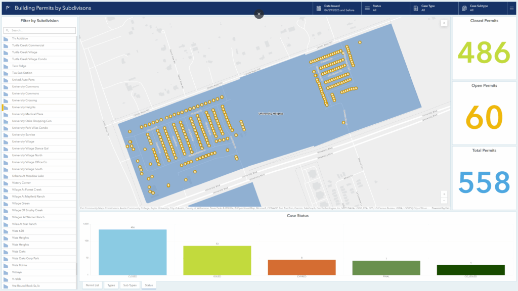
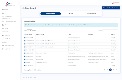
To modernize its permitting process, the City of Round Rock needed an online platform where residents could submit applications, schedule inspections, pay fees, and monitor progress. The city wanted dashboards to provide instant assessments of building permits in the system. In addition, city personnel needed a way to streamline water meter installations without a third-party software integration.
Implementing New Technology
The City of Round Rock implemented Trimble Cityworks PLL to reduce paper processes and enable real-time permitting management. Integrated with ArcGIS, Trimble Cityworks PLL allows the municipality to process permit applications and contractor registrations digitally, resulting in a 46 percent reduction in permit processing time. Instead of manually entering data from paper documents and exchanging PDFs via email for approvals, stakeholders now receive automatic notifications when it’s their turn to sign in, review, and sign off. “Even if you’re a developer based out of state, you can apply for building permits through our portal instead of traveling to our office with a piece of paper,” says Smith.
The city also uses Cityworks PLL with ArcGIS Utility Network, a location-based data model and management system designed to manage utility and telecommunications infrastructure. When a new water meter is entered into Geographic Information System (GIS), it must conform to predetermined rules from the Utility Network system. “There’s a specific model that the meter must adhere to,” Smith explains. “A meter has to connect to a service line, and a service line has to connect to the water main.” The network then creates a digital twin of the water network within Cityworks AMS. “Using [ArcGIS] Utility Network in conjunction with Cityworks is extremely powerful,” says Smith. “From there, we can click on that water meter asset and create a work order or an inspection, view a complete history, or see how much that water meter has cost the city over time.”
Before adopting Cityworks PLL, city employees relied on a custom integration to connect their old permitting system with Cityworks AMS. Now, the two processes are managed within the same platform. The work order to install a water meter “is simply a child work order of the PLL case,” Smith explains. “There’s no need for any integration.” Since implementing Cityworks PLL, the city has seen a 54 percent decrease in the time required to install a water meter after a permit is issued. What once took up to four days now takes just under two days.
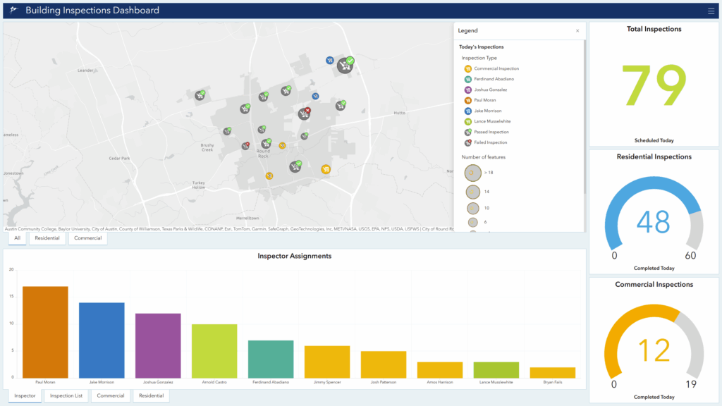
City employees also use Cityworks AMS to manage water and wastewater lines, parks, public buildings, streets, hydrants, and bridges. Relying on ArcGIS, Trimble Cityworks gives city personnel tools to track inspections, maintenance needs, and upgrades through web-based maps and dashboards.
New Technology Improves Collaboration and Efficiency
Since adopting Trimble solutions for permitting and asset management, the City of Round Rock significantly improved internal efficiency. Teams now use Cityworks to access real-time information and inspection updates on city-managed roads, buildings, construction projects, and other assets. “We’re able to confidently assess the value and need of each asset throughout its life cycle,” Smith says. “Anyone who needs insight into an asset’s status can simply log in and review the permit or project details.”
On the permitting side, residents submit applications through the Permit Portal, and city personnel can easily process those requests. Some permits require review and approval from multiple city departments, a process that previously relied on email. Now, it’s part of a digital workflow that automatically notifies each person in the approval chain. Personalized dashboards display tasks in a queue, allowing reviewers to complete each step within the platform. “We’re able to complete processes much more efficiently,” says Smith. Since implementing Cityworks PLL, the city has seen a 16 percent decrease in plan review processing time and a 58 percent decrease in inspection completion time. Contractors and residents now schedule inspections through the self-service Permit Portal, ensuring timely coordination and faster project progress.
Cityworks PLL/Cityworks AMS technology also serves as a connected data environment (CDE) for city employees across departments, with more than 1,000 users. Authorized staff can sign in and access key information at any time. For example, if a team needs to install water meters for a new building, the team can quickly check the permit status. “It’s really brought our city departments and employees together in a one-stop shop,” says Smith. “I can log in and get a holistic picture of what’s going on in every area.”
The City of Round Rock has also seen a major increase in on-time payments thanks to a simpler digital application process. The time from submitting an application to making the first payment has dropped by about 40 percent, from an average of five days to just three days. This efficiency saves city employees significant effort in processing payments. “We’re processing north of a million dollars per year through the Permit Portal,” says Smith. “Applicants can pay online with a card or ACH [Automated Clearing House] and later log in to check their approval status. There’s a lot more transparency in our processes.”
In the future, the City of Round Rock plans to integrate Trimble solutions with other types of enterprise systems, including enterprise resource planning (ERP) and financials.
“Our entire city has become more cohesive. I feel confident using Trimble and Esri solutions because they allow me, as well as city staff, to get information we need quickly. Having key information gives us confidence when we’re going into a meeting with stakeholders and executives.”
Nathan Smith, Geospatial Services Manager, City of Round Rock

Stay Connected with Esri’s Water Team
ArcGIS is an extensive information system that enables modernization of workflows with easy-to-use applications. Strengthen your organization with GIS-based solutions that will increase efficiency and provide insight for decision-makers. Visit the Esri Water Utilities web site for more information.
Join the Water Utilities Community
Follow #EsriWater on social media: X | LinkedIn
Subscribe to the Water Industry newsletter “Esri News for Water Utilities and Water Resources“