Before ArcGIS Utility Network, Tualatin Valley Water District (TVWD) in Oregon had reliable mapping and asset visibility but lacked a scalable way to quantify outage risk and compare alternatives across the entire system, especially for shutdowns. Engineering staff often relied on manual techniques and segment-by-segment reasoning to determine which valves needed to be closed and which areas would be affected.
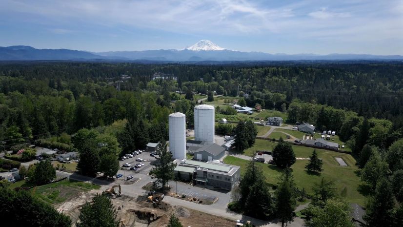
Through the Esri Advantage Program, TVWD completed an ArcGIS Utility Network readiness assessment and implementation plan. When TVWD set out to implement ArcGIS Utility Network, the goal wasn’t just modernization, it was optimization. Serving more than 222,000 residents across unincorporated Washington County and the cities of Beaverton, Hillsboro, and Tigard, TVWD needed a smarter way to evaluate its water system, prioritize capital projects, and respond to future needs.
Working closely with Esri partner NV5, TVWD implemented ArcGIS Utility Network and extended its capabilities with customized tracing tools tailored to the district’s business challenges. The result: actionable insights that help engineers make informed decisions about valve placement, redundancy, and system resilience.
“We didn’t want to just modernize our GIS [geographic information system technology]. We wanted a platform that could drive smarter decision-making and help us proactively manage risk across our system. This is about implementing today’s best-available technology to plan tomorrow’s water system.” Matt Oglesby, TVWD’s Asset Management Division Manager
Building on the Esri Foundation
ArcGIS Utility Network implementation laid a strong foundation. But it was the next phase—developing advanced trace configurations—that delivered real operational value.
Solving Real Problems with Custom Trace Analysis
TVWD needed to answer two pressing questions that directly influence resilience and capital planning:
- Where should we consider adding valves to reduce customer impact during planned and unplanned shutdowns?
- Where is our system single fed (supplied from one direction), increasing the risk of larger outages?
To answer these questions, the team distinguished between two related conditions that explain why and where action is needed:
- True dead ends (e.g., cul-de-sacs) that serve a purpose for flushing and typically do not require capital changes
- Single-feed areas where neighborhoods are unintentionally served by one main (These are candidates for looping or targeted valve placement.)
The two questions help identify the goals (minimize isolation effort; increase redundancy), and understanding the situations listed above helps staff separate expected design from risk-bearing conditions, guiding where TVWD should prioritize valves or looping to reduce customer impact.
To address these questions and considerations, NV5 developed and ran two system-wide trace analyses:
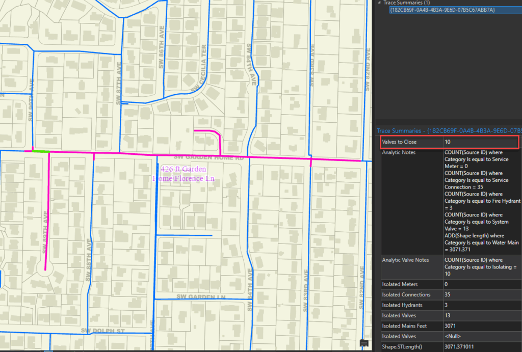
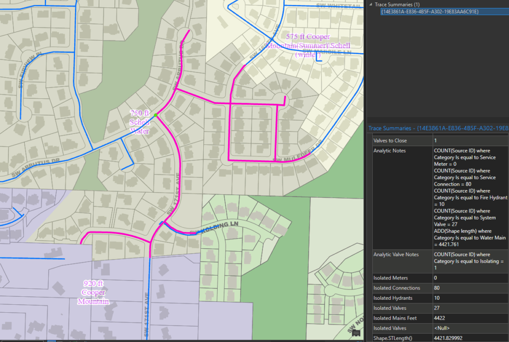
- Valve Impact Trace: For each of the 42,000 pipe segments in TVWD’s network, the trace calculated how many valves would need to be closed to isolate that segment. This helped flag areas—sometimes as many as a dozen—that required excessive valve manipulation just to isolate one pipe.
- Customer and Asset Impact Trace: For each potential isolation, NV5’s tool calculated how many customers, hydrants, and feet of main would be affected. This summary provided a clear view of where outages had disproportionate impacts and where looping or new valves could reduce risk.
Both traces were automated and repeatable, allowing TVWD to refresh the analysis periodically as the water system evolves. These tools are now part of TVWD’s GIS quality control, ongoing planning, and operations workflows.
“Our GIS team has always provided us with access to accurate mapping. We’ve been able to quickly identify which valves we need to close in response to a pipe break. We had an incident years ago that would have required a shutdown of nearly one mile of 24-inch main affecting nearly 800 customer connections. Luckily, our operators quickly devised several system manipulations that greatly reduced the size of the outage. Now, we’re able to find areas of our system that are susceptible to impacts like this and add valves or additional pipes to increase resiliency before an emergency occurs.” Pete Boone, TVWD’s Chief Operating Officer
Enabling Smarter Capital Investment
TVWD’s engineering team now uses these trace results to identify capital improvement opportunities, such as new valve installations or main extensions that would reduce the number of customers affected during emergencies or maintenance. The analysis also supports operational planning and emergency preparedness.
For example, in one part of the system, isolating one segment of main required shutting off a dozen valves across several blocks. Elsewhere, a single valve closure impacted more than 800 customers due to a lack of looping. These scenarios are no longer hidden—they’re visible, measurable, and addressable.
A Foundation for the Future
The collaboration with NV5 has left TVWD staff with more than just answers—it left them with tools. The team can now run system-wide traces on demand, simulate what-if scenarios, and bring data-driven recommendations to stakeholders and leadership.
“This wasn’t just a consulting engagement. It was a collaboration and a knowledge transfer. NV5 took our vision and logic and delivered a toolset and the knowledge to keep building on this work.” James Kivley, TVWD GIS Analyst
With its ArcGIS Utility Network implementation complete and intelligent trace tools in hand, TVWD is better positioned than ever to ensure system resilience, optimize investment, and reliably serve TVWD’s customers.

Stay Connected with Esri’s Water Team
ArcGIS is an extensive information system that enables modernization of workflows with easy-to-use applications. Strengthen your organization with GIS-based solutions that will increase efficiency and provide insight for decision-makers. Visit the Esri Water Utilities web site for more information.
Join the Water Utilities Community
Follow #EsriWater on social media: X | LinkedIn
Download the Building a Modern Network Information Management System eBook
Subscribe to the Water Industry newsletter “Esri News for Water Utilities and Water Resources“