This morning, I woke up to a hilarious email. My boss excitedly (my emphasis) writing to tell me that “weird bird people” are applying for the opportunity to take advantage of the $1 million Esri has set aside for small nonprofit grants, through the Esri Small Nonprofit Organization Grant Initiative.
“Weird bird people” are my people. All weird-ologist people are my people. I want to see my people taking advantage of the same technologies and capabilities to revolutionize how they succeed in their goals as the big corporations and their government partners do.
There are over 1.8 million non-profits in the US, of which roughly 20,000 are focused on conservation and education. Nearly 86,000 are focused on recreation. 10,000 on agriculture. The list goes on and on…
Collectively, you can imagine the sheer impact this has on our environmental and conservation work as a whole. It’s MASSIVE, integral, and should not be taken for GRANTed (pun intended.) I’ve seen firsthand the power of our Tennessee State Parks Friends Groups in facilitating the necessary trail maintenance work and other needs across our state’s 57 parks. I’ve personally been involved with our tiny little botanical chapter, the Tennessee Native Plant Society and seen their impact in educating the public and advocating for legislation on a wide variety of topics impacting our biodiversity.
Right now, we have an Infrastructure Bill and a “Climate Bill” that emphasize and seek to support the implementation of locally-led conservation efforts. The importance of these small organizations to help our nation succeed in our climate and environmental goals is not to be overlooked, and they deserve access to the best technology to help facilitate and further their missions.
Let’s look at some examples of nonprofits using GIS to conduct their critical environmental work.
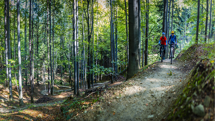
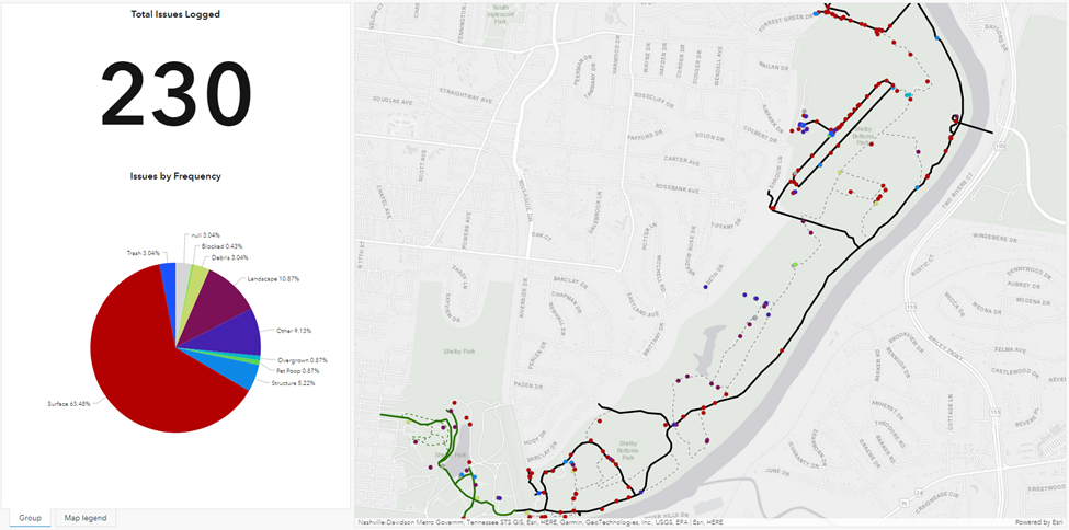
Park Maintenance
During COVID, it was my personal pleasure (and mental outlet) to help the Friends of Shelby Park & Bottoms with their trail maintenance inventory. This Metro Nashville park is massive for being in the middle of an urban center – 13,000 acres and nearly 20 miles of trails. The maintenance can be a beast and the Friends group plays a key role in maintaining and advocating for what is arguably Nashville’s most popular park. Using a simple combination of ArcGIS Survey123 and an ArcGIS Dashboard and a 2-hour training, we mobilized 10 volunteers to canvas the park and log maintenance issues. The dashboard allowed the group to easily filter which ones can be managed by volunteers and which ones required more serious work to be passed along to Metro Nashville.
Biodiversity Protection
This case study comes out of Hilton Head Island, SC where a small nonprofit helps hatchling sea turtles shuffle their way safely to the sea. To do this successfully, they must be able to accurately log and visualize the location of the nests when wooden markers were consistently vandalized, removed, or washed away from Hurricane Matthew.
Citizen Science
As someone who obsessively babies my Monarch cats in my milkweed garden every year, this is easily one of my favorite case studies. Despite not living in Chicago, I actually still signed up to receive notifications via the Chicago Field Museum’s ArcGIS Hub for their Monarch Butterfly Research and Protection Initiative. Using ArcGIS Hub Premium, volunteers can have virtual “identities” via their login, which the museum can then use to communicate directly with the volunteers throughout the lifecycle of the research. Hub can be used to facilitate training, communicate events, and provide the volunteers with the technology required to report their findings. Dashboards summarize the findings immediately, allowing volunteers to see their impact on the project immediately.
Education and Outreach
This story examines how a small non-profit group, Protect Our Winters, uses GIS technology to research and communicate the impact of climate change on winter sports – and the downstream impacts to local economies who rely heavily on the winter sport seasons. When topics like Climate Change can be abstract to talk about, they become very real when you can see them on a map and relate them specifically to where people live and recreate. By using maps, the group can rally their community behind a call to action.
So what is YOUR call to action? Apply for Esri’s Small Nonprofit Organization Grant Initiative. We’ve set aside $1 million to support small nonprofit organizations with the tools AND the training required to get up to speed and magnify your impact.
Apply here now.