Modernizing Right-of-Way Management with GIS
Right-of-way (ROW) acquisition is a complex, multi-stakeholder process that requires coordination across project teams, appraisers, negotiators, and external partners.
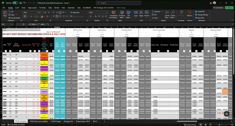
At Kimley-Horn, managing ROW acquisition efforts involved tracking parcel data, documentation, schedules, and financial information across numerous interconnected spreadsheets. These spreadsheets were often shared through email and maintained by different contributors, creating challenges in maintaining a consistent and reliable view of project status.
The organization recognized the need to improve visibility, coordination, and decision-making by moving toward a more integrated, accessible, and map-driven approach to managing ROW activities.
Challenge
The existing spreadsheet-based workflow created several operational and data management challenges:
- Fragmented data across multiple linked spreadsheets with complex dependencies
- High risk of formula errors, data corruption, and broken logic
- Limited real-time visibility due to static, emailed files
- Inconsistent stakeholder access and collaboration
- No spatial context to understand parcel relationships and progress
- Manual reporting processes with limited ability to monitor schedule performance
Together, these challenges reduced efficiency, increased risk, and limited confidence in project data.
Solution
Kimley-Horn developed a configurable ROW management solution—based on geographic information system (GIS) technology—that centralizes data, streamlines workflows, and improves collaboration. The solution integrates ArcGIS Online, ArcGIS Experience Builder, ArcGIS Survey123, ArcGIS Dashboards, ArcGIS Notebooks, ArcGIS for SharePoint, and ArcGIS for Power Automate to create a unified, web-based system.
Key Capabilities
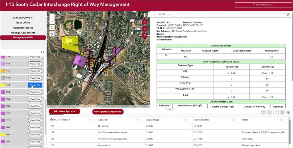
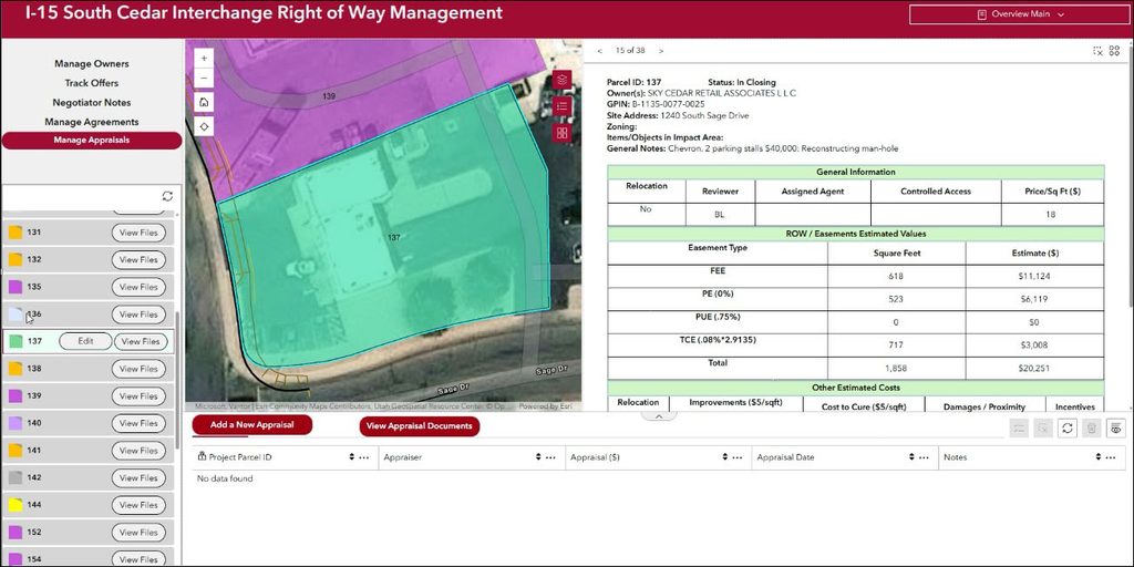
The solution provides a centralized, map-driven environment that brings together parcel data, documentation, and workflows into a single system of records. Users can view, update, and manage parcel information in real time, improving both visibility and coordination across stakeholders.
Core capabilities include:
- A centralized web application serving as a single source of truth for all ROW data
- Map-based parcel visualization with detailed attribute and document access
- Configurable data entry forms with built-in validation and consistency controls
- Automated calculations and status updates based on project dates
- Integrated document management through SharePoint for organized file access
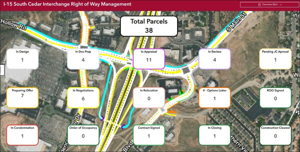
- Real-time dashboards and reporting to monitor progress and schedule performance
Results
By replacing disconnected spreadsheets with a centralized GIS-based system, Kimley-Horn improved operational efficiency, enhanced collaboration, and provided real-time visibility into project status. Teams now have a continuously updated view of ROW activities, enabling faster decision-making and better project control.
Key outcomes include:
- Reduced time spent managing spreadsheets and reconciling data inconsistencies
- Improved data accuracy through structured inputs and automated calculations
- Enhanced collaboration with shared, up-to-date access for all stakeholders
- Increased transparency through real-time dashboards and reporting
- Better schedule management with dynamic tracking and visual indicators of progress
- Scalable foundation for future enhancements, including expanded reporting and workflow automation
Lessons Learned
The implementation also highlighted several best practices for organizations pursuing similar transformations:
- Document system functionality clearly to support onboarding and adoption
- Provide training to ensure consistent use across teams
- Establish clear permissions to control data access and editing
- Plan for change management and adoption over time
- Maintain backups to mitigate challenges with data rollback
Closing Thought
By moving from fragmented spreadsheets to a centralized, map-driven system, Kimley-Horn established a modern foundation for managing right-of-way acquisition. The integration of GIS with configurable applications and enterprise systems demonstrates how organizations can improve data integrity, enhance collaboration, and gain real-time insight into complex infrastructure workflows.
Learn more about location intelligence for AEC:
GIS for Architecture, Engineering, and Construction.
Stay Connected with Esri’s AEC Team:
Subscribe to the AEC industry newsletter “Esri News for AEC”.