Empowering the Producer Community
Agricultural cooperatives have long supported producers, with more than 1,600 operating in the United States and over 3 million worldwide. They enable producers to share costs, strengthen their collective bargaining power, and improve their position within the supply chain.
This year’s Esri User Conference featured the SAG Award winning Sugar Cane Growers Cooperative (SCGC) of Florida as an illustration of how to properly apply GIS technology. Sugar Cane is a particularly interesting crop because it must be processed within 24 hours of harvest. SCGC needed to coordinate continuous harvesting, transportation, equipment assignments, and mill capacity across 150 consecutive days with exceptional precision.
The Esri Farms and Ranches Concept
SCGC also offers a valuable model for supporting agricultural producers. Their approach has been incremental, guided by clearly defined needs and anticipated business outcomes. Each capability has been implemented, evaluated, and refined before the cooperative advances to the next priority. This systems-based approach helps farmers move harvested crops efficiently to the processing plant without overwhelming them with unnecessary technology.
The broader agricultural technology industry has not always followed this model. Producers are often expected to manage excessive amounts of information, disconnected applications, specialized point solutions, and growing compliance requirements. Modern farming should not require advanced technical expertise simply to navigate the tools intended to support it. When a solution adds complexity rather than reducing it, producers may disengage or allow only a limited opportunity for the technology to demonstrate value.
A more effective approach begins by considering the farm or ranch as an integrated system. In GIS terms, a farm or ranch is commonly represented as a collection of mapped polygons, such as fields, pastures, or paddocks. Many organizations use this geographic framework primarily for asset management, placing stationary or moving assets on a map and, in some cases, incorporating real-time information from soil sensors, equipment, or livestock. Knowing where assets are located is important, but location awareness alone does not deliver the full value of GIS.
A Concrete Example: Esri Ranch
Greater value comes from decision-support services that provide producers with the specific information or automated assistance they need at the appropriate time and location. Many start-ups and government organizations have developed effective solutions for individual agricultural challenges. However, even valuable point solutions can contribute to application overload when producers must access, interpret, and manage each one separately.
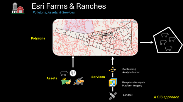
In ranching, virtual fencing for precision grazing illustrates this challenge. A rancher may want to guide livestock toward areas with abundant forage by creating virtual grazing boundaries for collar-based systems such as Nofence. Rather than estimating where to draw those boundaries, the rancher first needs reliable information about the location and condition of available forage.
USDA’s Rangeland Analysis Platform, or RAP, provides satellite-derived vegetation cover and production information that can support rangeland monitoring, grazing decisions, and stocking-rate analysis. However, RAP does not independently convert forage information into virtual fence boundaries. That requires an additional geoprocessing service capable of identifying suitable forage areas and generating polygons that can be provided to a virtual fencing system. A system that advises and automates this process is the key to reducing information overload.
The Co-Op Model
Although this workflow provides meaningful value, it remains another point solution unless it is incorporated into a broader enterprise framework. The full value of enterprise GIS is realized when multiple services, datasets, and analytic models can be managed and delivered as part of a coordinated system.
This is where the cooperative model becomes especially relevant. An agricultural cooperative is a producer-owned organization that helps farmers work together to purchase inputs, share services, market products, and achieve economic outcomes that may be difficult to attain individually. A virtual cooperative could extend this model by using technology to foster the development and delivery of analytic services tailored to individual producer needs. GIS would serve as the system of record that connects data, models, applications, and participating organizations.
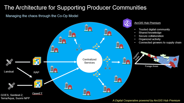
Within this model for ranches, RAP information could be delivered to a central service hub that identifies which ranchers need the data and adapts the resulting analytics to the conditions of each operation. The same framework could support crop production. For example, a producer growing corn for feed may need to irrigate only selected portions of a field served by a center-pivot system.
OpenET provides satellite-based evapotranspiration data that can help producers and water managers understand crop water use and support irrigation decisions. When integrated into the same service framework, OpenET-derived information could be delivered only to the farms, ranches, and fields where it is relevant.
As these services are combined, conventional farm and ranch maps become service maps. One field may use a geofencing analytic model, another may use an irrigation model, while some may use both or neither. The system becomes increasingly valuable as additional services are introduced, while the cooperative helps determine which producers receive each service according to their specific needs.
ArcGIS Hub Premium provides the collaboration and engagement framework needed to support this concept. It can help cooperatives establish digital ecosystems organized around shared goals. Through a secure online destination, producers, advisors, researchers, and partners can collaborate, share information, access decision-support tools, and participate in programs designed to improve productivity, sustainability, and resilience.
Scaling the Esri Farms & Ranches Conceptual Framework
Creating a service-based architecture and delivering it through a geospatial farm/ranch model is necessary, but potentially inefficient when considering a large number of producers encapsulated in a co-operative model. Creating accurate polygon sets representing large farms is often a hurdle many producers are not interested in taking. It is worse for governments like the USDA who must capture crop acreage reports from accurate field boundaries represented as polygons in order to support producer subsidies.
Esri has introduced an offering, called Land Analytics, that combines nationwide Regrid parcel data with 250+ curated attributes spanning environmental, infrastructure, climate, land use, and risk data to create a standardized parcel intelligence layer for the United States. Delivered monthly as cloud-ready Parquet files, Land Analytics provides a consistent foundation for enterprise-scale land acquisition, management, conservation, and development workflows. This capability would be a starting point for managing farm boundaries within the Esri Farms & Ranches conceptual framework.
Applying Agentic AI to the Cooperative Model
As discussed in the blog Agriculture Intelligence (AgI): Lessons from Old School Artificial Intelligence (AI), building the aforementioned infrastructure for AI is critical for its success and for quickly adding agentic AI into the mix. But, what would enabling that framework look like with agentic AI?
For that, below is a conceptual demonstration of how to configure Esri tools to build an AI Ranch Advisor that can help guide a rancher through the process of designing a grazing management plan for a GPS-enabled collar system for cattle. The AI Ranch Advisor acts as a personal extension service consultant, guiding the rancher towards effective and efficient grazing.
Turning this vision into reality will require more than technology—it will take a committed community of producers, cooperatives, researchers, public agencies, and industry partners working together to strengthen the agricultural food chain. By combining enterprise GIS, shared services, and agentic AI around the needs of each operation, the Esri Farms and Ranches concept can transform fragmented tools and data into practical, timely decisions for producers. To explore how this collaborative model can be put into practice, visit our recent webinar, Esri Farms and Ranches: An Architecture for Supporting Producer Communities.
Special thanks to Charlie Magruder who came up with the concept of Esri Farms and who recently retired from Esri!