Reflecting on the lessons of past cycles in artificial intelligence, the agricultural industry must carefully consider how to adopt emerging technologies without repeating historical missteps. The experience of the “AI winter” underscores the importance of aligning robust data management infrastructure with the inherently geospatial nature of agriculture, emphasizing the need for trusted, centralized—yet flexible—systems capable of supporting diverse farming operations and supply chains. Unlike sectors that can standardize easily, agriculture’s fragmentation and sensitivity to global market pressures demand solutions that prioritize data integrity and interoperability, enabling efficiencies while adapting to climate and economic volatility.
So, how do we build those?
It starts with the recognition that agriculture, by its very nature, is inherently in the business of land management. And, what better way to manage land than use a GIS?
An Agriculture ArcGIS Platform
Perhaps the greatest contribution of GIS to geography was the notion that layering maps digitally can serve as basis for data management, just as relational database management systems ideally served the financial banking industry and object-oriented databases perfectly supported the scientific community. There are three key ingredients for establishing GIS in agriculture as a platform: data integrity, multiple deployment options and the ability to incrementally grow capabilities.
Data integrity in GIS depends on, and largely means the development of accurate maps. Each layer in a GIS actively represents a distinct set of geographic features or attributes—such as soil types, crop distributions, water sources, or land use—and the overall system relies on how precisely users create, maintain, and integrate these layers. Inaccurate or poorly managed layers can lead to misleading analyses, faulty decision-making, and ultimately undermine the trustworthiness of any AI-driven or data-driven applications built on a GIS platform. Therefore, rigorous data collection, validation, and ongoing stewardship of each layer are essential to ensure that GIS remains a trusted foundation for agricultural intelligence and geospatial analytics.
Anyone who has used ArcGIS can see that the tool set actively supports data integrity, and GIS professionals focus on rigorously applying a comprehensive set of geoprocessing routines to ensure that. Process integrity is ensured through the transparent linking of geoprocessing routines into a workflow that addresses a particular business problem.
But, more important than rigor has been Esri’s commitment to supporting multiple deployment platforms. While efforts from government initiatives like FGDC are both laudable and useful for providing a comprehensive picture of agriculture and land management, in general, the business world operates on principles around competition, where data sharing is more difficult, even across nodes in the supply chain.
Here, ArcGIS’ ability to be deployed in a secure, federated architecture where support for interoperability (e.g., through adherence to industry standards and OGC-compliant web services) is critical. These standards enable seamless and secure data exchange, workflow sharing and system integration across diverse agricultural platforms, allowing data from multiple sources—such as remote sensors, satellite imagery, and farm management systems—to be efficiently combined and analyzed. By supporting these widely adopted data formats and protocols, ArcGIS ensures that the supply chain can collaborate across public & private organizations, promoting greater data integrity and utility within the agricultural intelligence ecosystem.
While ArcGIS’ federated architecture is crucial for industries like Ag, its ability to start small and evolve towards an enterprise implementation allows for a balance between investing in the technology and realizing incremental returns while mitigating risk. Organizations can start with a single desktop license, quickly develop unique workflows for their needs, drive immediate value, and be confident that work can be transferred to larger deployments later, including the cloud. Or, they can deploy in the cloud first as a starting point using fewer licenses of Esri’s SaaS offering, ArcGIS Online, only to later scale on the same platform. In these ways, Esri can serve both the single farmer as well as other Agribusinesses.
Accelerating the Geospatial Agriculture Platform
Certainly ArcGIS’ deployments in the cloud have provided an infrastructure for massively scaling incoming user requests – the Johns Hopkins Covid map, for example, was handing over four billion hits/day using Esri’s technology during the peak [source].
But, AI, image processing, and visualization have notoriously been greedy users of computational power and data storage, requiring a different compute paradigm that accelerates matrix operations, provides high speed bandwidth, and delivers massive parallelism. For this reason, it is not surprising that Nvidia’s Graphics Processing Units (GPU), which emerged out of the gaming community, have become the dominate force behind the emergence of modern AI.
In light of these developments, Esri has embraced the integration of ArcGIS with Nvidia to both accelerate visualization GIS and simplify its deep learning workflows [source]. Esri’s ArcGIS Pro takes full advantage of Nvidia’s optimized CUDA acceleration, enabling GIS users to experience noticeably faster rendering, smoother navigation through complex maps, and significantly shorter analysis times for demanding AI workflows. By tapping into GPU-accelerated computing, organizations can scale up to larger datasets, perform advanced modeling, and enhance throughput for agricultural intelligence.
Trusted GeoAI Ag Applications
The Ag industry landscape is littered with point solutions that each target particular aspects and workflows for agriculture to provide incremental improvements. While there is no doubt that they provide some value, many of these solutions grew up in a technical era that required access to IT talent that often migrated to higher paying industries, especially during the latest downturn of the ag venture capital in 2024. The solutions were often considered either too expensive or difficult to use by farmers.
In contrast, GIS presents an alternative to the traditional approach of developing point solutions. By treating ArcGIS as a foundational platform, it is possible to substantially reduce the time required for creating point solutions, while also enabling their integration to address a broader range of functional requirements.
Three examples worth noting are citrus greening disease control, cotton yield forecasting and assessing future corn suitability in the US.
GeoAI Object Detection for Citrus Greening Disease Control
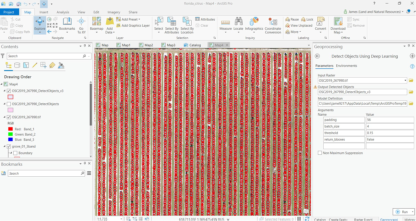
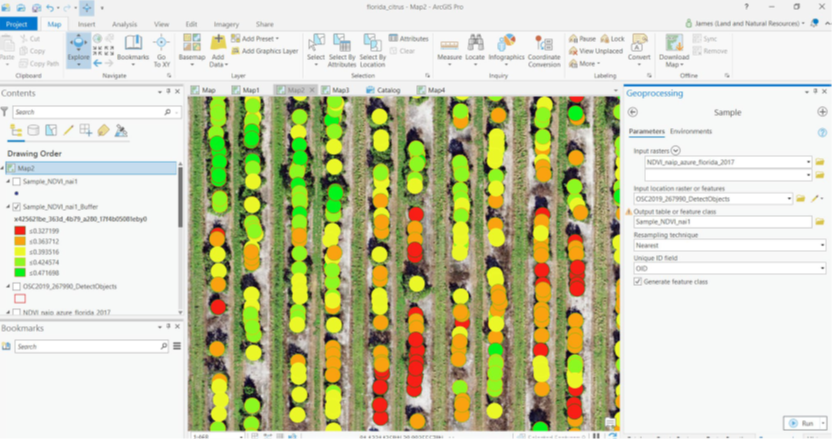
As a part of initiatives to control the devastating citrus greening disease, assessing the impact involves counting the diseased trees within groves by automatically circling trees as show in figure 1, through the use of Esri’s Deep Learning in ArcGIS Pro. When combined with vegetation indices, ArcGIS Pro provides a quick way to determine the health of the citrus groves as shown in figure 2 (see Precision Agriculture and Geospatial Techniques for Sustainable for Disease Control) With accelerated hardware applied to high resolution satellite data, counting every citrus tree in Florida, for example, becomes possible.
Pre-Trained Machine Learning for In-season Cotton Yield Forecasting
For common tasks, Esri has developed pre-trained models using the Deep Learning in ArcGIS Pro, where these models can easily be added into workflows that solve broader problems. For example, consider cotton yield forecasting at the field level where one can evaluate growing degree days and link climate data to specific fields, as illustrated in figure 3.
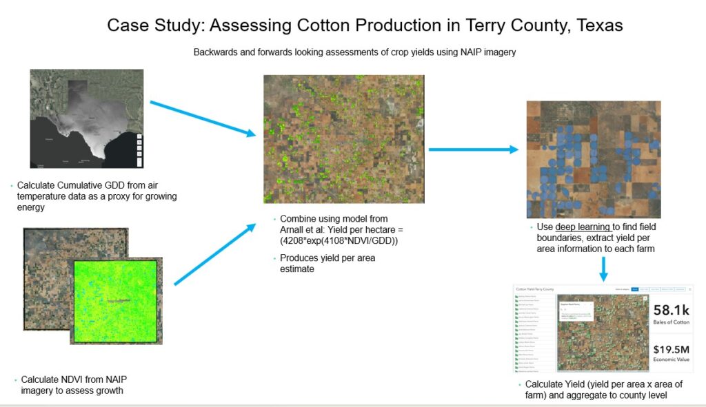
This workflow is streamlined because the platform provides access to both the required data and geoprocessing routines. In particular, the process involves generating a vegetation index from NAIP 4-band imagery, then integrating it with temperature data (growing degree days) mapped to field boundaries, which are produced using pre-trained deep learning models (see Raster Analytics story map and pre-trained crop boundary models for more details). With readily available data from Skywatch on the Esri platform, yield forecasting can be performed as often as necessary (see the webinar, “Easily Access and Task Satellite Imagery in ArcGIS”), making it possible for farmers to asses risks to the harvest during the growing season. All of this is created on a scalable, secure and trusted platform.
Machine Learning Geoprocessing for Long-term Forecasting of Corn Suitability
While the cotton yield forecasting workflow illustrates the use of AI using a pre-trained model against easily accessed data on the ArcGIS platform, more complex modelling techniques must be used for problems like determining corn suitability in the next few decades. Assessing corn suitability involves identifying ideal planting zones and analyzing how these areas may shift over time as weather patterns change. The business implications are significant given the large capital investments in placing processing plants closer to crops, that may eventually be planted further north.
With the potential migration of crops northwards as described in “Evaluation of Maximum Entropy (Maxent) Machine Learning Model to Assess Relationships between Climate and Corn Suitability”, it is critical to get the right model chosen and validated. To do that, a common modelling workflow is to compare models to determine the optimal model for use, which, in the case of corn suitability, means a Maximum Entity model wins. ArcGIS provides a robust suite of geospatial models for data scientists to experiment and to quickly make the right determination. Although created for different purposes, each of the examples can benefit from implementation on a single platform. The object detection for citrus trees can be reused for crop field boundaries. Cotton yield forecasting techniques can be repurposed for other crops like corn. While crop yield forecasting focuses on the short-term, longer-term forecasting models can be combined for a more comprehensive view over time, driving policy making and longer-term investment. Reuse of capabilities means shorter development times and a faster realization of benefits.
Conclusion
In summary, leveraging GIS and ArcGIS as foundational platforms transforms the traditional landscape of agricultural problem-solving by enabling rapid, scalable, and integrated solutions. The article highlights practical applications ranging from GeoAI-powered object detection for citrus greening disease control to pre-trained machine learning models for cotton yield forecasting and advanced geoprocessing for long-term corn suitability assessment. These examples demonstrate how modern geospatial technologies can accelerate decision-making, improve resource management, and enhance risk assessment across diverse agricultural challenges.