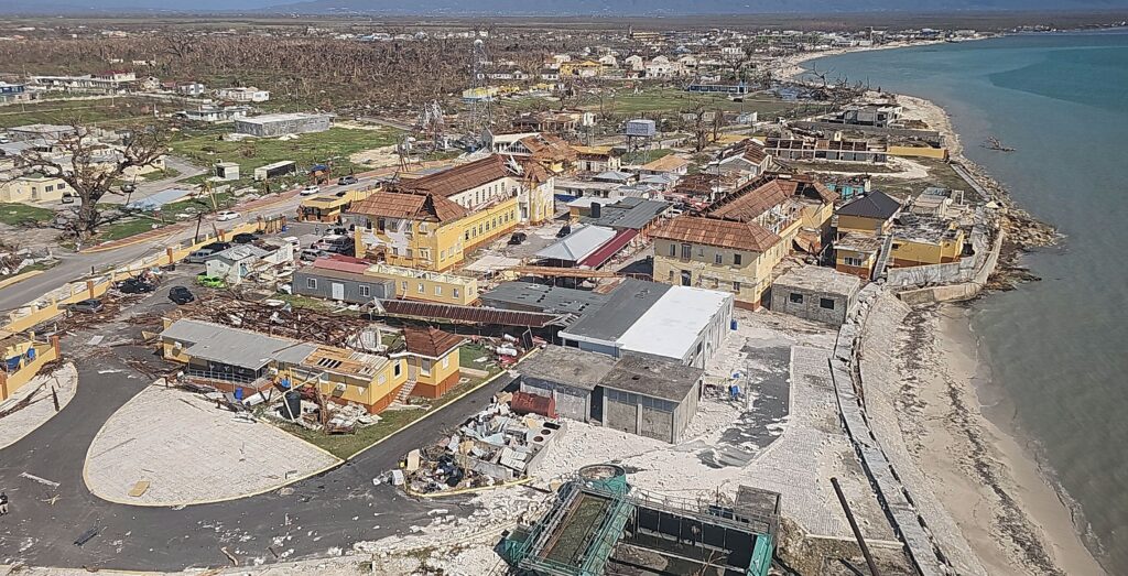
When Hurricane Melissa roared ashore on October 28, 2025, as a Category 5 storm—the strongest to strike Jamaica in decades—the Government of Jamaica demonstrated what true preparedness looks like. Despite catastrophic winds, flooding, and landslides that devastated western parishes and disrupted power and communications, Jamaica’s response was swift, coordinated, and data driven. This success was no accident. It was the result of years of investment in governance, technology, and geospatial readiness.
A Foundation Built Before the Storm
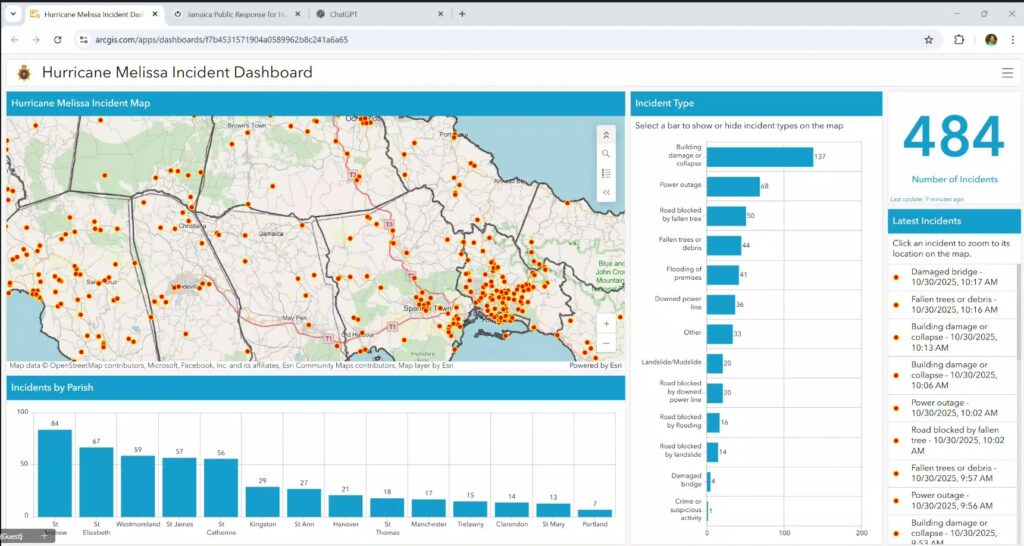
Long before Melissa was on the radar, Jamaica had integrated Esri’s geographic information system (GIS) technology into its emergency management system. The National Emergency Operations Centre (NEOC), with support from the Office of Disaster Preparedness and Emergency Management (ODPEM) and the National Spatial Data Management Branch (NSDMB), developed clear protocols for data management and operational dashboards. The NSDMB activated the National Emergency Response GIS Team (NERGIST), a group of volunteer GIS experts coordinated through the branch. From the first activation meeting, the team developed a support layer, including operational information, with support processes assigned to assist in the response to Hurricane Melissa. These systems were not just theoretical—they were operational and tested, enabling Jamaica to shift quickly from planning to action as Melissa approached.
Days before landfall, ODPEM escalated the country to full response posture and published high-risk community lists. NEOC briefings aligned ministries, utilities, and humanitarian partners under one common operating picture. This proactive stance meant that when the storm passed, Jamaica could issue an “All Clear” and immediately transition to restoration and recovery.
“We had to streamline everything—from drone coordination to shelter dashboards—because when you’re in Jamaica, and you have a drone, you want to help your country. But we needed governance and workflows to make that help effective,” said NSDMB principal director Alicia Edwards, reflecting on NEOC’s approach to integrating volunteer and private-sector resources.
Impact and Immediate Action
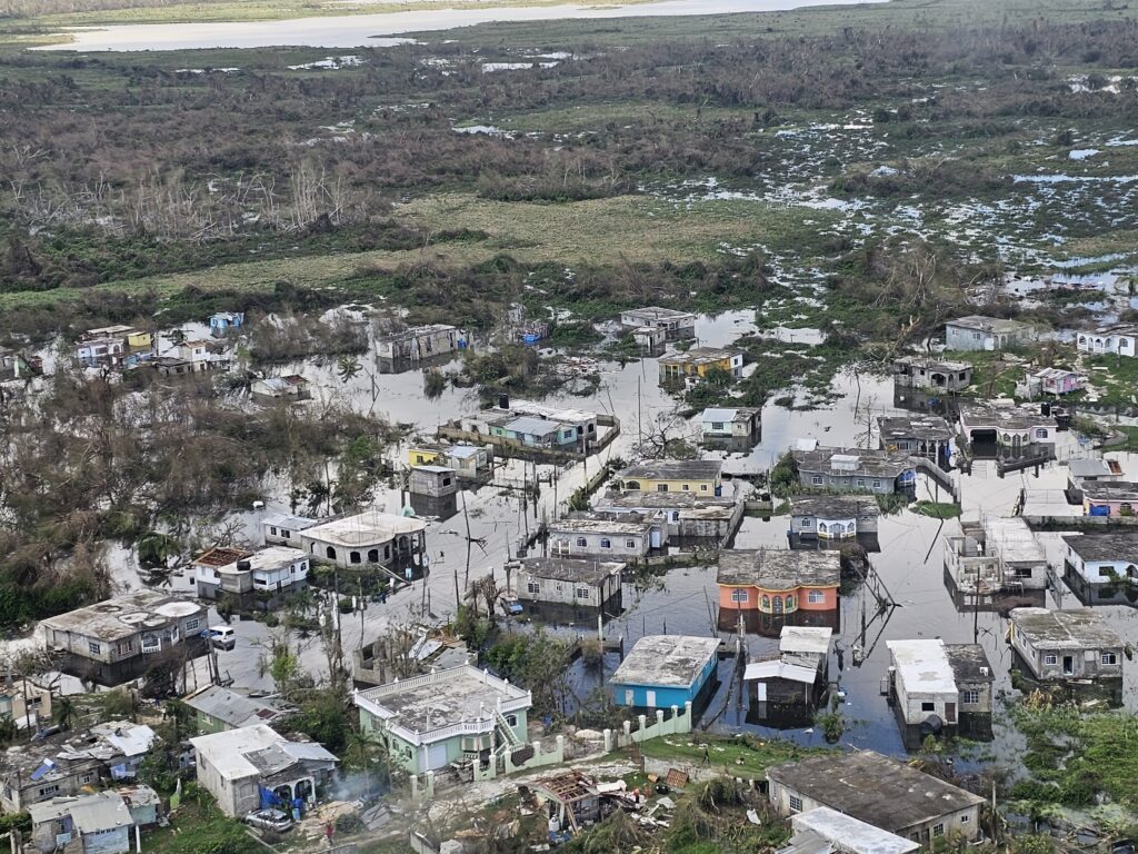
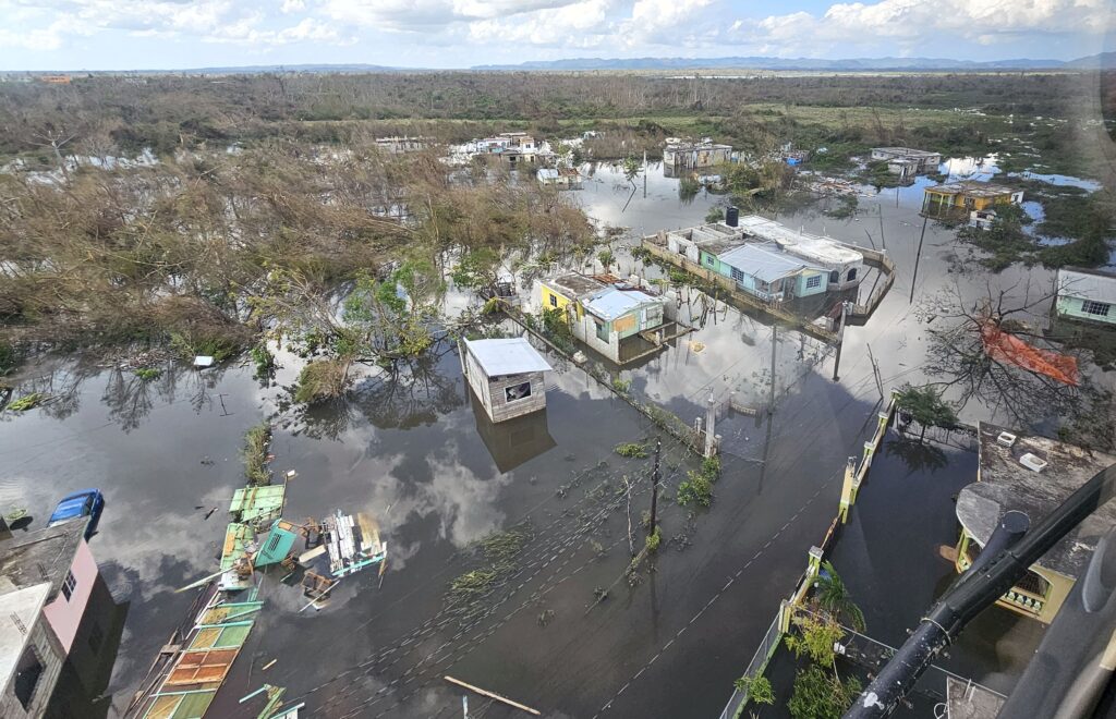
Melissa’s impact was severe: widespread flooding, structural damage, and prolonged outages across western Jamaica. Yet, even amid these challenges, the government maintained situational awareness. Hundreds of shelters were activated and tracked in real time through centralized dashboards. Status updates flowed every few hours, enabling logistics teams to route relief supplies efficiently and prioritize vulnerable communities.
Then, acting through NERGIST and coordinated by NSDMB, NEOC’s GIS-driven workflow integrated authoritative data from national agencies with field intelligence from volunteers and academic partners. Reporting based on community data gleaned from WhatsApp was converted into geospatial layers, giving decision-makers ground truth when traditional communication networks were down. This fusion of official and community data ensured that no area was overlooked.
“Our goal was to ensure that every update—whether from a drone team or a shelter manager—fed into the national picture. That’s how we kept everyone aligned,” noted Edwards.
Esri’s Disaster Response Program’s Role in Strengthening Jamaica’s Response
While Jamaica led decisively, Esri’s Disaster Response Program (DRP) was activated and provided critical technical reinforcement behind the scenes. The DRP helped configure the ArcGIS Survey123 intake forms and the ArcGIS Dashboards for shelter status monitoring, ensuring NEOC had a single source of truth for occupancy and resource needs. The DRP also facilitated the rapid integration of ICEYE synthetic aperture radar (SAR) imagery and Copernicus Emergency Management Service damage maps into Jamaica’s operational dashboards, giving Edwards and her team near real-time visibility into flood extents and building damage.
DRP staff worked closely with NSDMB to stand up secure ArcGIS Online groups for authoritative data sharing and supported workflows for volunteer data ingestion, including converting crowdsourced reports into GIS-ready layers. These actions amplified Jamaica’s ability to maintain a common operating picture and accelerate decision-making during the most critical hours.
“We’re integrating ICEYE radar data and optical imagery into our national dashboard. It’s encouraging to see how well these layers align with the damage classification framework we’ve been using,” said Edwards, emphasizing the role of advanced analytics in refining Jamaica’s recovery picture—a process made possible through the DRP’s coordination with imagery providers.
Data-Driven Decisions at Every Stage
Jamaica’s preparedness extended beyond local data. International partners provided rapid imagery and analytics, including flood and damage assessments from satellite sources. These insights informed everything from shelter management to utility restoration. The prime minister underscored the importance of GIS in post-storm briefings, signaling a commitment to resilience measures such as critical infrastructure—a decision rooted in spatial analysis.
Recovery efforts also leaned heavily on geospatial intelligence. Damage and loss assessments guided housing programs, infrastructure repair, and financing strategies. Agencies like the Planning Institute of Jamaica (PIOJ) used GIS outputs to align recovery priorities with real-world impact, ensuring resources flowed where they were needed most.
Lessons in Preparedness
Jamaica’s success during Hurricane Melissa offers a clear lesson: Preparation wins. By investing in GIS capabilities, governance structures, and interagency coordination before disaster struck, the Government of Jamaica transformed a potential catastrophe into a model of resilience. Their ability to see, decide, and act—powered by data—accelerated recovery and set a benchmark for disaster management in the Caribbean. Esri’s Disaster Response Program was proud to support this effort, reinforcing Jamaica’s leadership with tools, imagery, and expertise when it mattered most.
Learn more about Esri’s Disaster Response Program or how agencies use GIS in public safety.