Community organizations, government agencies, and activists have continuously pushed equity to the forefront of U.S. policies and regulations. However, recently citizens have demanded greater transparency from government organizations in their efforts to advance equity and social justice within their communities. Esri, the global market leader in geographic information system (GIS) technology is committed to providing community leaders and governments with the tools necessary to increase this transparency, enhance community engagement, and target at risk communities. This was clear at this years Public Sector CIO Summit, where a major theme heard throughout the event was equity and how leaders across the nation are leveraging GIS technology to address it within their communities. This summit is an invite only event where CIOs from leading organizations share insight into their best GIS practices.
I had the pleasure of leading an equity workshop at the summit alongside Harvard’s School of Public Policy and hosted our chief equity officer network through demonstrations and conversation about their equity related challenges and solutions. This was the first of many convenings for our chief equity officer network and it is certainly off to a great start. While some leading organizations are leveraging location-based solutions to address inequities we still have a lot of work to do. I hope that by reading my blog you are inspired by the contents of this event and reach out to get started.
Throughout the event and the equity workshop, five major themes were continuously highlighted:
- Advancing equity within your communities requires a strategic plan.
- GIS technology serves as a hub for all data and operations.
- We must establish data standards, especially in regards, to race, gender, and ethnicity.
- GIS tools allow you to easily track projects funded by grants.
- GIS technology can enhance your community outreach efforts.
Develop a Strategic Equity Plan
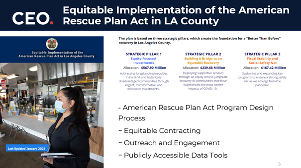
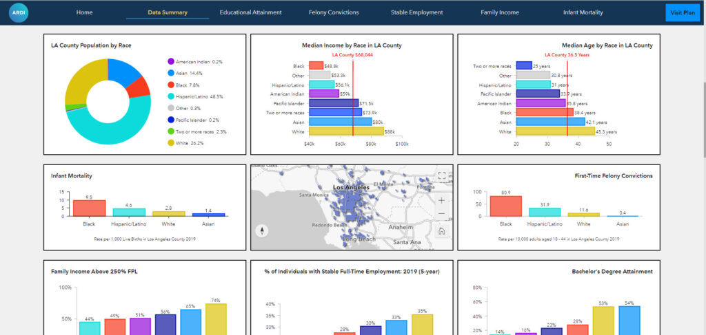
Equity related work is not for the lighthearted, to successfully promote equity, you must operationalize your vision with a strategic plan. At the CIO summit we heard from Los Angeles’s County CEO Dr. D’Artagnan Scorza, who shared how LA county prioritizes equity work through federal funding. LA County leverages GIS technology to determine which communities require prioritization, what resources and programs would enhance equity in these communities and most importantly to show where funding is being applied for greater transparency. LA County is not the only jurisdiction we heard from that have created a GIS strategic equity plan and we hope to see more.
GIS Technology Connects All Data and Operations
Equity work should be a collaboration between many departments at an organization. However, without a system to connect this work this can almost seem impossible. GIS provides an opportunity to find ways to centralize, catalog, and make resources across departments available. It is a system that connects and enhances existing systems, allowing users to connect their work and data. Conversations during the equity workshop highlighted how the use of GIS allows these government leaders to centralize their data and make it available to sometimes 40 departments. This was a huge milestone for these organizations as access to data can sometimes become the roadblock into seeing where interventions are required, and which communities are at-risk.
Establishing Data Standards
Although, I would like to say that this event only highlighted positive outcomes it also highlighted some challenges within this work. A key challenge many leaders noted was the standardization of their data, especially around race and gender. Without a data standard, departments within the same organization may collect and define their data differently, which complicates reporting and response efforts. A great practice LA county noted was establishing a data committee within your organization which will help clear up these misunderstandings and will also help connect departments within your organization that may not work alongside everyday but would benefit from this sort of collaboration.
Tracking Federal Funding
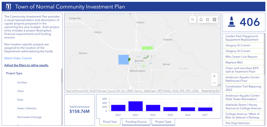
In an effort to provide status updates and full transparency to residents and stakeholders, GIS provides you with the tools necessary to easily track investments and project status. Attendees of the equity workshop expressed the need to update multiple stakeholders especially for projects involving different departments within the organization. GIS technology like ArcGIS Dashboards, can also help with updating your community on project updates as these can be shared publicly as seen below.
Enhance Community Outreach with GIS
A key part in enhancing equity within your organization is applying community feedback and needs. GIS tools provide your organization with technology to easily survey your community, monitor results, and apply the responses to your work. Aside from collection tools, products like ArcGIS Hub also provide your organization with the ability to update your community on valuable data sets, projects status, and serve as a site to continue collecting feedback and sentiments.
Equity Remains at the Forefront of CIOs Initiatives
Our first equity workshop proved that enhancing equity is not a community issue or an activist issue but an organizational issue. As leaders we must leverage innovative technology that allows us to connect our departments and streamline our efforts. We learned that everyone has a role and data guides our decisions but to move equity forward modern technology is essential. I believe that CIOs can connect their organizations by leveraging GIS, which provides their departments with the necessary tools to enhance equity within their work.
To ensure you are invited to our next meet up join our LinkedIn group at go.esri.com/ESJgroup