Does your organization have complete land information readily available to inform critical decisions? Are your parcel maps always up to date, accurate, and accessible to all stakeholders? Can you easily see a parcel’s history and legal transactions without extensive research? If you answered no to any of these questions, your current parcel management practices are holding your organization back, resulting in unnecessary expense. It is time to modernize your parcel management with ArcGIS Parcel Fabric.
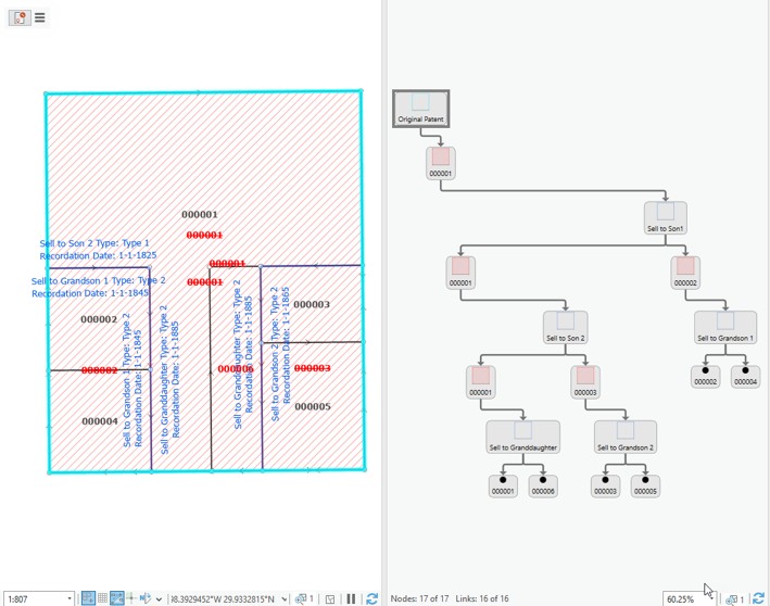
Land is complex, and ArcGIS Parcel Fabric is Esri’s solution for parcel mapping and management. Every land transaction begins with a legal record, such as a development plan, plat, deed, easement, or record of survey. Land parcels in the ArcGIS Parcel Fabric are created and edited in response to changes in the legal record. Storing legal references for parcels is built into the ArcGIS Parcel Fabric and is paramount for trust and data longevity, as noted in xyHt’s article, “Advancements in Parcel Mapping Tools – Part 1.”
In addition to tracking the legal record that causes parcels to be created and edited, the ArcGIS Parcel Fabric also tracks history as parcel configurations change. Land records are cumulative. However, most traditional parcel management methods capture only a snapshot in time, meaning all previous work and history are lost. With ArcGIS Parcel Fabric, you enter a land record once, and you will have it forever, minimizing rework.
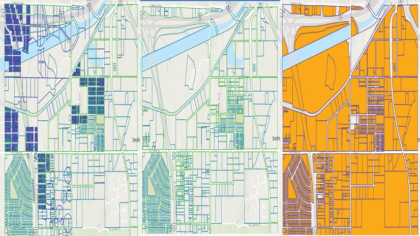
The ArcGIS Parcel Fabric has a flexible data model and is composed of separate parcel types, such as subdivision/plat boundaries, lots, easements, rights-of-way, and tax parcels. Each parcel type can be customized, and parcels can be managed in the third dimension (3D) and even the fourth dimension (4D), enabling you to track parcels above and below the ground, and over time.

Additional functionality includes least-squares adjustments, which improve the spatial confidence and accuracy of the land records data. Part 2 of xyHt’s “Advancements in Parcel Mapping Tools” article highlights this as a particular strength, as these robust adjustments can be made directly in ArcGIS Parcel Fabric with no additional data importing or exporting.
It also accommodates attribute rules and constraints, which streamline workflows and minimize data errors. Additional features, such as COGO Reader, further enhance productivity by automating the labor-intensive process of manually entering data from deeds to create parcel geometry. (If you haven’t had a chance to check COGO Reader out, it’s worth a few minutes of your time – this is coming from someone who, in a previous life, spent countless hours manually entering land record data…)
ArcGIS Parcel Fabric can also support multiple concurrent editors, scaling to your organization’s needs, and is services-oriented [accessible through the web], making it available to stakeholders no matter where they are. For example, Tooele County, Utah, leveraged this capability to increase efficiency between two different departments, improving both efficiency and accuracy.
Are your teams a blend of CAD and GIS users? No problem. By leveraging services and the ArcGIS for AutoCAD integration, your teams can work together on the same dataset in an environment that’s most comfortable for them.
Land parcels are the foundational decision-making layer for governments and private companies alike, as was highlighted during and after the wildfires that devastated Maui County, Hawaii, in 2023. Careful stewardship of parcel data has always been a priority for Maui County, but when disaster struck, it underscored the value of land records and parcel data in ways no one could have imagined.
In a world fraught with increasing demands and decreasing resources, modernizing your parcel management should make the top of everyone’s New Year’s resolution list. In my next blog, we’ll explore all the ways you can leverage your modernized parcels for better decision-making.
Oh, and remember – ArcMap will no longer be supported starting March 1, 2026. If you haven’t upgraded, make that your first priority with parcel migration to the ArcGIS Parcel Fabric included in your strategy.
Check out the following resources for more information on ArcGIS Parcel Fabric and the next steps you can take to implement it in your workflows: