As Philadelphia, PA natives Boyz II Men said, it’s long overdue, but now Esri is headed to Philadelphia for NRPA 2026.
Esri is proud to support another NRPA Conference, this year in Philadelphia, PA. Here is your conference to-do list:
Stop by the Esri Booth (#2211) in the Exhibit Hall and:
- Visit with our team of subject matter experts to see how ArcGIS can help you blaze a trail to smart parks.
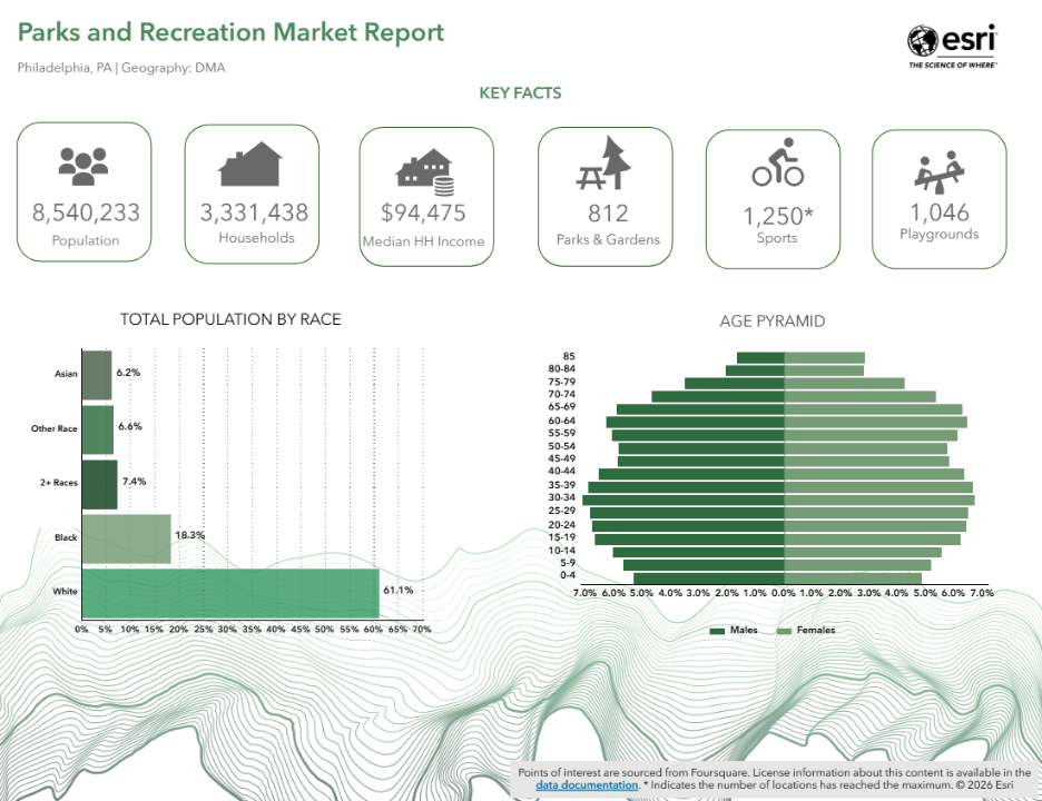
- Get your custom parks and recreation market report for your city or county.
- Learn about our 29 parks and recreation ArcGIS Solutions.
- Visit our partners in the exhibit hall to learn more about how they can support your mission.
- Check out the GIS sessions at the conference.
- Review our online parks and recreation resources.
Here are the details to help you check off each item above.
Discover How ArcGIS Supports Parks and Recreation
Our team will show you how ArcGIS supports the full spectrum of parks and recreation, including:
- Planning & Design
- Smart Operations
- Education & Outreach
- Community Health & Wellbeing
- Access
- Climate Resilience
We have assembled a talented group of subject matter experts from across the company and country to help you learn about the latest GIS trends and how you can maximize your investment in GIS.
Meet the Esri NRPA Booth Team
- Adam Carnow, Industry Specialist, Charlotte, NC
- Christopher Thomas, Industry Solutions Manager, Redlands, CA
- Claire Smith, Account Manager, Chesterbrook, PA
- Eva Macek, Solution Engineer, Chesterbrook, PA
- Francis Kelly, Lead Partner Manager, Louisville, CO
- Jason Latoski, Senior Solution Engineer, Sacramento, CA
- Matt Bullock, Principal Product Engineer, Louisville, CO
- Renee Opatz, Senior Consultant, Olympia, WA
- Sergio Gutierrez, Industry Marketing Manager, Redlands, CA
- Tyler Kriminger, Solution Engineer, Charlotte, NC
Find us at the Esri Booth 2211
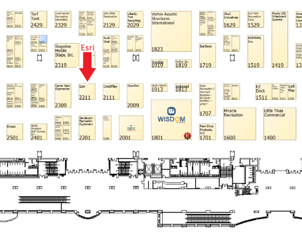
Booth Hours
- Tuesday, September 29: 10:30 AM to 4:30 PM
Dedicated hours: 10:30 AM to 1:00 PM - Wednesday, September 30: 10:30 AM to 3:00 PM
Dedicated hours: 10:30 AM to 1:00 PM
Get Your Custom Parks and Recreation Market Report
While visiting the booth, be sure to get a custom parks and recreation market report for your city or county created with ArcGIS Business Analyst.
Visit Our Partners in the Exhibit Hall
Don’t forget to visit our partners in the exhibit hall to learn more about how they can support your mission:
- Accela booth #958
- AssetWorks booth #2521
- CivicPlus booth #719
- OpenGov booth #2009
- Schneider Geospatial booth #2049
- Trimble booth #1919
Explore 29 Parks and Recreation ArcGIS Solutions
Be sure to explore our 29 parks and recreation ArcGIS Solutions. These are included, supported, industry-specific configurations of ArcGIS that utilize your authoritative data and help improve operations, provide new insight, and enhance services.
More than 60 organizations have deployed over 500 of these solutions. In the last year, the top five solutions deployed were:
Add These GIS Sessions to Your Agenda
- Integration of GIS in Athletic Field Planning and Management – Montogomery Co., MD, Tuesday, Sept. 29, 2:45 PM – 3:10 PM, Exhibit Hall Speed Sessions Section A, Booth# 2747
- Improving Park Asset Management with the Asset Request Tool (ART) – Montogomery Co., MD, Wednesday, Sept. 30, 12:30 PM – 12:55 PM, Exhibit Hall Speed Sessions Section A, Booth# 2747
- Introduction to GIS for Park Asset Management – Champaign, IL, Wednesday, Sept. 30, 1:15 PM – 1:40 PM, Exhibit Hall Speed Sessions Section B, Booth# 246
- Rooted in Community: A Blueprint for a Sustainable Tree Adoption Program – San Antonio, TX, Wednesday, Sept. 30, 4:15 PM – 5:15 PM, Room 115AB
- Bringing History to Life: Archives to Action Through Technology, Recreation and Storytelling – Minneapolis, MN, Thursday, Oct. 1, 9:00 AM – 10:00 AM, Room 111AB
- Reaching High-Hanging Fruit: Simple Drone and Geographic Information System Wins That Help Parks Fly – Lincoln, NE, Thursday, Oct. 1, 2:30 PM – 3:30 PM, Room 113AB
Access Parks and Recreation Resources Anytime
- Parks and Recreation website: Enhancing Parks and Recreation for the Next Generation
- Webinar Series: Next-Generation Public Works—Smart Parks Webinar
- Parks Enterprise GIS Guide: Planning Parks and Recreation for the Next Generation Brochure
Stay Connected

If you are interested in staying up to date on the latest parks and recreation technology trends, customer stories, GIS best practices, and ArcGIS innovations, subscribe to our monthly eBrief and explore our online resources.
See You in Philadelphia!