Last week, I had the privilege of attending the National Association of Development Organizations (NADO) Annual Training Conference (ATC) in Salt Lake City. ATC brought together regional leaders, planners, and economic development professionals from across the country. As usual, NADO’s annual event serves as both a professional recharge and a reality check, It offers an opportunity to learn from peers, hear from national thought leaders, and dig into the pressing issues challenging and shaping regional development.
This year’s conference reinforced several key themes that continue to define the work of Regional Development Organizations (RDOs): the central role of housing in economic vitality, the growing reliance on AI and data-driven tools, and the need for innovative strategies to overcome the challenges of limited resources and growing demands.
A Game Plan for Regional Economic Strategy
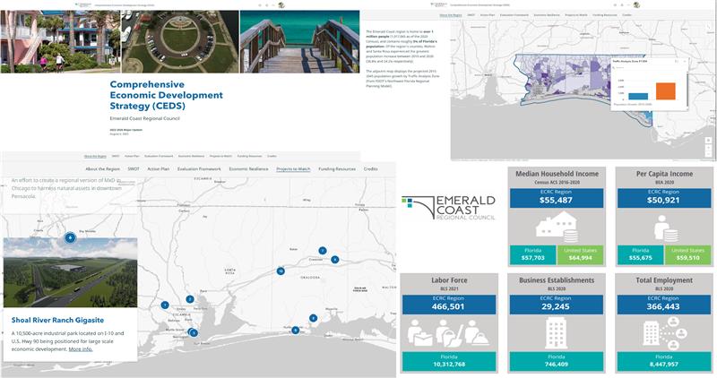
During the conference, I had the opportunity to lead a Learning Lab. I illustrated how Economic Development Districts (EDDs) can integrate Geographic Information Systems (GIS) into their work with the Comprehensive Economic Development Strategy (CEDS). The CEDS is the backbone of regional economic development planning and is structured around four core pillars:
1. SWOT Analysis – Understanding regional strengths, weaknesses, opportunities, and threats.
2. Strategic Direction & Action Plan – Setting a course for investment and growth.
3. Evaluation Framework – Measuring progress and adjusting strategies as needed.
4. Engagement & Collaboration – Ensuring all stakeholders have a voice in shaping the future.
GIS plays an integral role in each of these components. Whether it’s mapping regional assets and infrastructure, identifying areas of economic distress, or visualizing where investments can have the greatest impact, GIS helps turn abstract strategies into actionable insights. This isn’t a new concept. NADO Research Foundation’s 2023 study reveals over 90% of EDDs now incorporate GIS, mapping, and analytics into their CEDS processes.
During the session, we laid out a game plan for how a geographic approach can make CEDS implementation more data-driven, transparent, and inclusive. Attendees shared examples of how spatial analysis has helped them secure grants, align projects with regional priorities, and communicate complex data to elected officials and the public in clear, visual ways.
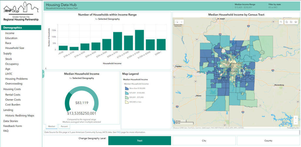
Housing Is Economic Development
Another recurring message—echoed not only at NADO but also at conferences like IEDC, APA, and NLC—is that housing is economic development. A March 2024 report from the Bipartisan Policy Center showed that the nation faced 8.8 million unfilled jobs. Many unfilled jobs are linked to housing affordability constraints that directly affect employers’ ability to attract and retain workers. Communities across the country are recognizing this directly shapes their ability to attract and retain workers, sustain local businesses, and promote economic mobility.
This has ripple effects on transportation, workforce participation, and overall community livability. As we discussed throughout the conference, addressing housing shortages isn’t just about zoning reform or increasing supply. It’s about aligning housing strategies with broader economic and workforce goals.
GIS again plays a vital role here. Regional governments are using location data to analyze housing affordability trends and identify suitable areas for development. In turn, this data reveals the relationship between housing, employment centers, and transportation infrastructure. A healthy regional economy depends on a housing strategy that meets the needs of today’s and tomorrow’s workforce.
The Role of AI in Regional Development
It’s no surprise that artificial intelligence (AI) was another hot topic at NADO ATC. AI has quickly gone from being a futuristic concept to an everyday tool in RDO offices. Whether it’s drafting sections of a CEDS, supporting grant writing, managing data, or streamlining internal workflows, AI is a standard part of the toolkit for regional planning and economic development professionals.
AI can help RDOs do more with less—an increasingly important capability given the growing demands on these organizations. But as several speakers emphasized, the key is pairing AI’s efficiency with human judgment and local context. When combined with GIS, AI can unlock powerful new insights from regional data, helping RDOs identify trends, model scenarios, and make faster, more informed decisions.
Why Geography Matters
The final takeaway from NADO ATC was that many RDOs are being asked to do more with less. Whether they’re managing Economic Development Districts, Area Agencies on Aging, or other regional programs that support local governments and communities.
As federal and state resources tighten while community needs grow, RDOs must find smarter, more efficient ways to plan and deliver services. That’s where GIS and a geographic approach come in. By combining data, mapping, and analytics, RDOs can better understand where needs are greatest, prioritize investments, and communicate the value of their work in a way that resonates with decision-makers and the public.
The NADO Annual Training Conference served as a powerful reminder that regional development is, at its core, about connection…connecting data to decisions, communities to opportunities, and people to places. Through GIS, AI, and collaboration, RDOs are finding innovative ways to strengthen the regions they serve.