Powerful threat intelligence in easy-to-create visualizations
Geospatial technology provides vital tools that embrace the intelligence life cycle, supporting threat intelligence workflows and investigative link analysis. Fuse raw data from multiple sources in real time, detect networks and relationships, and share tradecraft. Whether you are an intelligence analyst, technologist, or operator, you can easily organize complex threat data into a visualization that is easy to interpret, understand, and share to support threat mitigation and investigations.
An intelligent operations center
Analyze
Understand
Share
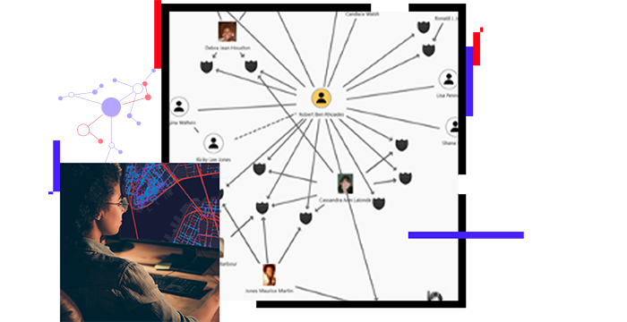
Facilitate incident analysis and data fusion
Leverage geospatial technology to facilitate a multisource investigative intelligence analysis. Fuse data from foundational and dynamic incident intelligence sources in real time. Engage operators, analysts, and technologists with interrelated maps, charts, graphs, and tables. Deliver robust visualization that informs operations.
Detect networks and relationships
Execute link analysis that focuses on connections within a dataset that contains hidden social networks. With ArcGIS you can detect hidden relationships through networks of interconnected nodes. Give security teams the tools to analyze and understand the links and patterns in threat data, creating opportunities to disrupt adverse behavior.
Share tradecraft
Develop, capture, and share tradecraft across your organization. ArcGIS enables tradecraft-sharing libraries, allowing threat intelligence workflows to be documented and standardized. This provides analysts an enhanced ability to remain agile and respond to changing conditions without having to adjust the program baseline.
ArcGIS Blog
Use ArcGIS Insights to track virus spread
Experts view contact tracing as a way to help control the spread of COVID-19. Link charts can visualize the relationship between potential cases.
Go to the blog
ArcGIS Blog
Create a link chart using ArcGIS Pro Intelligence
Learn, step by step, how to build a link chart and visualize potential threat relationships within your data.
Go to the blog
ArcGIS Blog
What's new in ArcGIS Pro Intelligence 2.7
Discover new tools to analyze movement data, leverage new symbols for dignitary protection and law enforcement, and much more.
Go to the blog
ArcGIS Blog
Extend GIS to the entire organization
ArcGIS Insights empowers analysts—from novices to experts—to connect to enterprise databases and use drag-and-drop functionality for spatial analysis.
Go to the blog
ArcGIS Blog
Crime analysis tools in ArcGIS Pro
A new solution for crime analysis supports performing tactical, strategic, and investigative analysis and sharing information products.