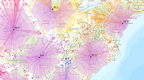
Skip to Content

Modern GIS in Higher Education

From desktop GIS to Web GIS

Curriculum and lecture resources for educators and researchers

A photo of a bright modern classroom of casually dressed young adults seated in front of a row of laptops and computer monitors

Students need a curriculum that reflects GIS today

From Mylar to microservices, geographic information system (GIS) technology has changed a lot over its 50-year history, yet GIS education has not kept pace. There is a clear mismatch between the desktop-focused GIS curriculum, which is still the foundation of many GIS courses, and the Web GIS that students will encounter when looking for internships or jobs. Students who understand modern GIS concepts and can apply modern GIS technologies will be more competitive and have the skills they need to succeed in their careers.

A photo taken over the shoulder of a student wearing a red plaid shirt, focused on a laptop on a scarred wooden library table displaying a map dashboard

Modern GIS is Web GIS

Thousands of cities, agencies, nonprofits, and businesses depend on Web GIS. Moving the locus of GIS from the desktop to the web makes it mobile, automated, responsive, interconnected, cloud based, and configurable—these themes are an integral part of a modern GIS curriculum.

previous
Next

USER STORY

Modernizing GIS education to ensure career success

Monroe Community College launched a multifaceted GIS microcredential program to help students keep pace with industry trends and modern skill sets.

Read the user story

Webinars

previous
Next

Community

Looking for ideas? Want to connect with other educators from across the globe? Curious to hear about the latest in GIS technology? Esri staff focused on GIS in higher education as well as your peers would love to hear your questions and insights.

Four students looking at the monitor

Esri Community

Join the conversation in the Esri Community space devoted to GIS in education. Post your questions, read blogs, and hear from your peers.

Explore Esri Community

GIS in Higher Education Chat

Join colleagues and the Esri education team on the first Tuesday of each month to learn about tools, data, materials, and teaching approaches.

Register for the next chat

GeoTech Center

The GeoTech Center hosts curricula, model courses, and a large community of educators in the geospatial field.

Explore GeoTech Center

American Association of Geographers

The American Association of Geographers (AAG) is a nonprofit scientific and educational society founded in 1904. It provides professional development, publications, and opportunities for collaborating with your peers.

Explore AAG

Stay updated


Sign up for the education newsletter

Connect with the Esri education team