ArcWatch: GIS News, Views, and Insights
September 2012
Seattle versus Portland: Compare the Cities with a New Web Mapping Application
By Austin Amort
Esri, Olympia, Washington Regional Office
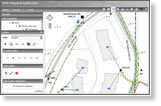
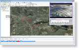
Compare and contrast demographic and quality-of-life data for Portland, Oregon, and Seattle, Washington, using a new web application developed at Esri. The Portland vs. Seattle Smackdown application was inspired by the CNN Travel summer series City Smackdowns.
The application compares factors such as population density, median household income, and park acreage in each city. It was built using ArcGIS Online, HTML, and ArcGIS API for JavaScript. Very little programming was required.
Read the article, see the application in action, and think about new ways you can use ArcGIS.

The Portland vs. Seattle Smackdown application lets you compare various aspects of the quality of life in the two cities.
Tip of the Month
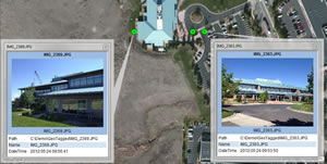
Easily Import Geotagged Photographs from Your Smartphone into ArcMap
Importing your geotagged photographs into ArcMap from your smartphone is easier than ever when you use the new GeoTagged Photos To Points tool in ArcGIS 10.1. Read this tip and get started using geotagged photos in your GIS workflows.
Connect with ArcWatch
ArcWatch is published monthly by Esri and contains GIS news, practical advice, and updates about the company's software and events. To submit article ideas, e-mail editor Carla Wheeler at arcwatch_editor@esri.com.
Join the Conversation
A Platform for Understanding
The planet faces great challenges while in the midst of major scientific discoveries and technological advances, says Esri president Jack Dangermond. "And we're creating unfathomable volumes of data in the process," he adds. "But data isn't enough. Clearly, we need more integrated knowledge and ways to be able to create better outcomes. We need to harness our technology and our brainpower to create a better future." Read his article.
Map Lights, Save Money
Holy Cross Energy, an electric cooperative in Colorado, used GIS technology to help update and correct its billing system for street and security lighting costs—a move that is saving the utility and some of its customers hundreds of dollars per month. Read the article.
Try ArcGIS 10.1 for Desktop for Free
Create maps with ease, do more advanced spatial analytics, and efficiently manage your data with the new ArcGIS 10.1 for Desktop. You can now access ArcGIS.com directly through ArcMap to search for data, import basemaps, and share geographic information with others. Learn more about the software's key features and sign up for a free, 60-day trial.
Planning for Light Rail Using 3D GIS
Esri 3D GIS visualization tools were used to help planners better understand the proposed route of a light rail system extension in Mesa, Arizona. Decision makers and citizens were able to see, in 3D, what downtown Mesa might look like after the light rail system was completed. Read the article.
Free ArcGIS 10.1 Seminar
Register to attend the free nationwide seminar ArcGIS 10:1: Transform Your Organization. In four hours, you will learn how ArcGIS 10.1 from Esri will make it easy to establish a mapping platform for your organization and how it can be used to create and share geographic information among departments, other agencies, nongovernmental organizations (NGOs), and citizens. Register today.
Podcast: Mapping Evil
Penn State faculty member Michael L. Thomas discusses the use of crime mapping techniques in tracking the movement of accused war criminal Joseph Kony in Africa. Listen to the podcast. You also can download it from the Esri podcast site.
Esri Launches European Wind User Group
The new Esri European Wind User Group will serve as a powerful resource for energy professionals who want to exchange ideas, success stories, and information about geospatial technology for on- and offshore wind farms. Read the article.
Apply for a Natural Resources Imagery Grant
The Esri and PCI Natural Resources Imagery Grant Program fosters innovative approaches to solving natural resource management problems by using GIS, image processing, and remote sensing technologies. Twenty organizations will receive awards, each valued at $100,000. Learn more and apply for a grant.
Wanted: Maps for Esri Map Book, Volume 28
Submit your maps for Esri Map Book, Volume 28, using the online submission portal. If your map is selected, it will be published in the book, which will be distributed at the Esri International User Conference in 2013. The submission deadline is 5:00 p.m. on November 16, 2012.
Geodesign Pioneer Honored
Harvard University professor Stephen Ervin received Esri's prestigious Lifetime Achievement Award for his pioneering work to integrate GIS and design. "Geodesign has taken over my life," he says with a chuckle. Read more about Ervin's views about geodesign in this blog post.
Happy Customers, More Profit
Executives from major companies— including General Motors, Jones Lang LaSalle, and Interstate Batteries—talk about the important role of location analytics for doing business. They were guest speakers at the 2012 Esri Business Summit. Read the article.
New Education E-books
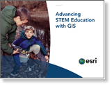
Esri has added two new education-related e-books to its collection of best practices publications. Advancing STEM Education with GIS includes case studies that detail successful implementations of GIS-based science, technology, engineering, and mathematics (STEM) classes. GIS in Education: Across Campuses, Inside Facilities focuses on the use of GIS to manage facilities in schools and universities.
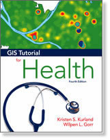
GIS Tutorial for Health
GIS Tutorial for Health, Fourth Edition, shows health professionals and students how to analyze and manage health data using GIS. Exercises cover health map basics, data preparation for maps, and spatial analysis of health issues. This volume supports ArcGIS 10 for Desktop software, which is included along with exercise data. Buy the book.

Newsroom


ArcGIS Full Motion Video
Download the ArcGIS Full Motion Video 1.0 add-in for ArcGIS 10 and ArcGIS 10.1 at ArcGIS.com. The add-in lets you play live streams of video or video files in your map. Frames from the video can be extracted as single georeferenced images or as groups of images stored in a mosaic dataset.
Top 10 ArcGIS 10.1 for Desktop Improvements
No. 10 is locating projections and no. 9 is tracking feature editing. Read the article to learn more about all 10 improvements in ArcGIS 10.1.
How to Make Your Pop-up Window Really Pop
Want to make a pretty pop-up window to match your map or website? Try this tip.
See You in Rotterdam, London, Madrid, or Berlin
If you live in Europe, schedule time to attend the Esri Developer Summit in Europe this November. Esri senior development staff will talk about what's coming next in GIS and help you better understand how to build web and mobile mapping applications.
Video: Realizing the Power of Geospatial Technology
How did Christchurch, New Zealand, respond to and recover from a series of earthquakes with the help of GIS? Listen to a talk by Maurice Williamson, minister of land information in New Zealand.
2013 Esri International User Conference Call for Papers
Write and submit your abstract now while your ideas are still fresh from the 2012 conference.
Get a Free Trial of ArcGIS Online
Download the New Version of ArcGIS for AutoCAD
Read the Latest Technical Articles
Esri Insider
What's the Big Deal about Big Data?
Everyone's talking about big data lately. It's the latest buzzword in technology circles. Never heard of it? The term simply refers to the ever-growing mountain of data generated from myriad sources that organizations must effectively address. Esri business and technologies strategist Victoria Kouyoumjian explains why big data is such a big deal in this blog post.Roving the Red Planet
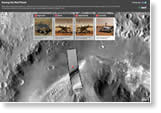
The National Aeronautics and Space Administration (NASA) rover Curiosity landed on Mars on August 6, 2012, and is at work conducting science experiments. In this Esri story map, travel to Mars to see where Curiosity landed. The spacecraft and its parachute, the sky crane, and the heat shield can be seen in the high-resolution imagery. The map also includes information about the other NASA rovers on Mars: Sojourner, Spirit, and Opportunity.
Go Geospatial on Nov. 14
Get inspired and involved! Host an event for GIS Day, which will be officially celebrated November 14, 2012. Register your event by September 30 and receive support for your celebration plus GIS Day gifts for your attendees, including tote bags, bracelets, magnets, and notepads.
Free Training for ArcGIS Online Subscriptions
Heard the buzz and want to start collaborating and sharing your maps and applications using ArcGIS Online subscriptions? These free training seminars will help you understand how to get started with a subscription and use the platform to work with your geographic information.
Two New Live Training Seminars
Esri will host the live training seminars ArcGIS 10.1 for Local Government on October 4, 2012, and Working with Imagery at ArcGIS 10.1 on October 11, 2012. Learn more and subscribe to receive reminders.
King County, Washington, Documents GIS Return on Investment
University of Washington economist Richard Zerbe conducted a study measuring the return on investment (ROI) of the county's enterprise GIS program: net benefits accrued were between $776 million and $1.7 billion. Read the article.
Staying Ahead of the Telecommunications Service Market Curve
Randy Frantz, Esri's telecommunications and location-based services manager, outlines how broadband and wireless network technology is significantly altering the telecommunications market. He also asks how service companies are adapting business processes to successfully compete in this new environment. Join him for a discussion at the Spatial Roundtable.
It's Back-to-School Time
Check out our September class schedule for the latest instructor-led and online course offerings. The children are back in school, so now it's your turn to learn some new things too!
Hardware Offers
Technical Talk
Web Resources and More
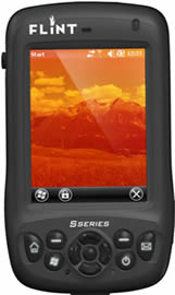 Esri offers US customers three new packages that include F4Devices Flint Rugged IP65 handheld GPS receivers. These lightweight, compact, and rugged devices come packaged with ArcPad. They also can be used with ArcGIS for Windows Mobile for ArcGIS for Desktop or ArcGIS for Windows Mobile for ArcGIS for Server. Learn more about all Esri and F4Devices offers.
Visit the Esri Store to find more software and extensions, upgrades, data, books, and hardware bundles.