The Headlines
-
In the new frontier of real-time GIS, Esri's ArcGIS GeoEvent Processor for Server ingests data streaming in from sources such as in-vehicle GPS devices and social media platforms, including Twitter. Read this article.

-
Data feeds for your GIS go real time. Maps in your tablets and smartphones go offline. These were just two pieces of important news that came out of the Esri International Developer Summit (DevSummit). Read this article to get the full scoop.
-
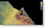
Journey down under with Duncan Mallace of the marine survey company MMT as he explains the value ArcGIS for Maritime: Bathymetry brings to exploring the oceans. Watch the video.
News Bytes
-
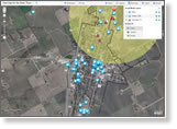
Plan for evacuations and decide how to protect vital infrastructure using the ArcGIS for Local Government flood planning map. View this video to learn how to use the map.
-
How might London's 1854 cholera outbreak be tracked today using GIS? University of Oregon students re-created the scenario using ArcGIS Online and social media. Read the article.
-
Round-trip directions and a new Map Tour template, for starters. Read the blog.
-
Learn how to take geodesign from science to practice during Geodesign Summit Europe, September 19–20, 2013, in the Netherlands. Register today and submit a paper.
-
A picture of where people go for Medicare services emerges using the Medicare Mapper for the iPad, developed by Critigen; Social & Scientific Systems, Inc.; and Esri.
-
Find a game plan at the Esri Business Summit for performing better business analytics. The secret? Location, location, location.
Centerpoints
-
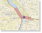
This Esri public information map shows where the fertilizer plant explosion occurred in West, Texas, and maps the social media posts in the aftermath of the blast and fire.
-
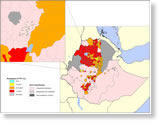
The International Trachoma Initiative uses Esri technology to assess the areas where there's a prevalence of trachoma, a disease that causes debilitating eye infections and sometimes blindness. Read the article.
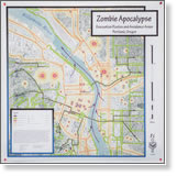
-
Maps of icebergs. Maps of tax revenue. Maps of earthquake intensity. Even maps of evacuation routes for the zombie apocalypse. See maps like that in the Map Gallery at the Esri International User Conference (Esri UC). Submit your map by May 31, 2013.