ArcWatch: GIS News, Views, and Insights
November 2011
Keeping an Eye on the Storms
By Karen Richardson
Esri Writer
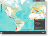
The 2011 hurricane season in the United States churned up many severe tropical storms such as Irene, Arlene, Bret, Emily, Harvey, Maria, and Rina.
Meteorologists always track these tropical storms, and so do insurers and reinsurers. They use ArcGIS technology and data from Esri for location intelligence, which helps them accurately calculate risk in their coverage areas and make the timely decisions needed to help their clients recover from hurricanes and other catastrophic events as quickly as possible.
Hurricane Irene, which caused severe flooding and wind damage in states such as New Jersey, New York, and Connecticut last August, exemplifies why it is important to know the exact location of both insured properties and the intensity of the storm.
In this article, Esri insurance industry solutions manager Mark McCoy details how and why location intelligence with ArcGIS is becoming so valuable to the insurance industry.
Amica Mutual Insurance is one of the companies that uses ArcGIS to track major storms. Read Amica's story.

Viewing wind speed on a map helps insurers monitor how much they must pay based on the intensity of the storm at each location.

Tip of the Month
Explore Raster Data Using Pixel Inspector
The Pixel Inspector tool lets you view pixel values in a raster dataset being displayed in ArcMap. The tool is similar to the Identify tool; however, it will display an array of pixel values instead of a single pixel value. Read this tip to learn how to use Pixel Inspector.
Connect with ArcWatch
ArcWatch is published monthly by Esri and contains GIS news, practical advice, and updates about the company's software and events. To submit article ideas, e-mail editor Carla Wheeler at arcwatch_editor@esri.com.
Join the Conversation
The Light Gray Canvas Map
 Do you want your thematic information on your map to stand out clearly? Then try using Esri's new Light Gray Canvas Map, which gives you a neutral, uncluttered background on which to display your data. "Today, people are using street, topographic, and imagery basemaps less often for their web map applications," said Mamata Akella, design lead on the Light Gray Canvas Map project. "We see a more minimalist basemap pattern emerging. It's providing this nice visual starting point on which people are overlaying their thematic information." Read the article.
 ArcGIS for Android Is Here
 You can now use Google Android to access data and mapping capabilities on your smartphone. How? By using Esri's free ArcGIS for Android application. Just download the app directly from the Android Market. Find out what you can do with this versatile app that Esri just released and how developers can also use ArcGIS Runtime SDK for Android to build customized apps for Google Android.
Learn the Latest about Government GIS
Join us at the Esri Federal GIS Conference, which will be held February 22-24, 2012, in Washington, D.C. You will hear about the latest trends and policies driving GIS projects throughout government and find out how your peers use the geographic approach to improve accountability, cut costs, manage data, support research, and streamline operations. Registration is free for federal employees. Learn more and register today.
Making Better Use of Space
The National Aeronautics and Space Administration (NASA) Langley Research Center in Hampton, Virginia, used GIS to optimize office space and reduce maintenance costs. Using Esri technology, a GIS team there developed space utilization optimization tools to map out and analyze the use of each area. Read the article.
Newsroom
Call to Present at the Esri UC
There's still time to submit an abstract for a presentation at the Esri International User Conference next summer. Giving a presentation lets you share your ArcGIS strategies, tips, and accomplishments. Submit an abstract no later than Nov. 30, 2011.
Mapping Quakes over Time
 Using ArcGIS technology and data from Esri, you can create a timeline map of magnitude 5 and greater earthquakes that occurred around the world from 1970 to 2010.
Spotting Deteriorating Roofs with Imagery and ArcGIS
Hill Air Force Base (AFB) in Utah uses ArcGIS and thermal infrared radiation (IR) imagery to identify failing roofing and utilities. Read the article.
Where to Park at the Airport?
In this video, Gady Pitaru of the City of Phoenix, Arizona, Aviation Department demonstrates how GIS is being used to help people find convenient parking spots at Phoenix Sky Harbor International Airport. Visit Find a Spot to see how one of the parking lot applications work.
Tracking Donations with GIS
Direct Relief International uses GIS web applications to keep donors apprised of where and how their contributions are being spent. Read the article. Visit the Haiti Aid Distribution map to see the value of the donations such as medical supplies and prescription drugs and where these items are being distributed.
Present at the Esri EdUC
Share what you have learned about the benefits of using GIS technology with your peers at the Esri Education User Conference (EdUC) next summer. Learn more about being a presenter and submit your abstract by January 13, 2012.
Conference to Focus on Future of Geocoding
Do you have a vested interest in how changing technologies will affect geocoding? If so, register to attend the International Geospatial Geocoding Conference, December 6-7, 2011, in Redlands, California.
A Speedy Solution
 With no budget for a property reappraisal project, the tax and GIS departments in Guilford County, North Carolina, turned to some valuable free ArcGIS applications to create a photo geotagging system that let them accurately match photographs of single-family homes with parcel records stored in a computer-aided mass appraisal (CAMA) system. Read the article.
Top Traits for a GIS Career
 What do you think are the top five traits or skills you need to succeed in GIS? Esri education manager Joseph Kerski compiled his list, which includes curiosity. "Successful GIS professionals are inquisitive not just about geospatial technologies but also about the world around them," he says. Curious to find out what other skills and traits Kerski considers valuable for pursuing a GIS career? Read the article.
A New Edition of Map Use
 Map Use: Reading, Analysis, Interpretation, Seventh Edition, from Esri Press, covers the skills needed to effectively read and understand maps and includes a new section dedicated to interpreting environmental maps. With lab exercises and other supplementary instructor resources for a cartography and map design curriculum, the book also serves as a general cartographic resource and primer for GIS technology. Order the book.
Technical Talk
A New Dimension for GIS
 CityEngine from Esri turns 2D GIS data into high-end 3D content using features, attributes, and defined rules. The more detail you can provide for each element, the more complex and realistic your 3D content, such as buildings, streets, trees, light poles, and cars. Read the article. Esri just released CityEngine 2011, which makes creating 3D models from 2D GIS data even easier than before. Learn more.
On Board with the iBus Widget
The Yakima Transit iBus widget, built with and powered by Esri technology, provides residents of Yakima, Washington, with the routes city buses are traveling, the vehicles' speeds, and the times the buses will arrive at their next stops. Read the article. See the iBus widget at work.
Manage a Custom Map Gallery with ArcGIS Online
Using the Public Maps Gallery template and other ArcGIS Online resources, you can create your own custom map gallery for your organization's website. Read the tutorial.
Using Automatic 3D Building Extraction to Enhance Your GIS
Beau Legeer of ITT VIS introduces the concept of using lidar data for generating 3D building models. Watch the video.
Introduction to ArcGIS Viewer for Microsoft Silverlight
Tune in to a free live training seminar on December 8, 2011, to familiarize yourself with ArcGIS Viewer for Microsoft Silverlight. Learn more and subscribe to receive a reminder.
Tune into Introduction to ArcGIS Runtime SDK for Android
Learn how to get started building mapping applications using ArGIS Runtime SDK for Android during this free live training seminar on January 19, 2012.
Submit an ArcGIS Idea
Esri wants to hear from you about ways to improve ArcGIS. Visit ArcGIS Ideas to get started.
Top 10 Questions to Answer before Publishing Your Map
Spatial Roundtable
 GeoDesign for Adapting to Climate Change
Esri president Jack Dangermond discusses how GeoDesign can play a role in adapting to our changing climate. Join the discussion at the Spatial Roundtable.Esri Insider: GIS by Anyone
 When programmers leave an organization, complex custom GIS applications that only they understand how to develop and maintain sometimes fall by the wayside. Esri's Bern Szukalski says that in some cases, the solution lies in a simple configurable application. ArcGIS Online and ArcGIS Viewer for Flex make creating these applications so easy that even nonprogrammers can build them. Read Szukalski's Esri Insider blog.
Web Resources and More
Monitor Floods in Thailand
 See what people using social media are reporting as flooding continues to engulf Thailand. Ushahidi updates include alerts about broken dikes, road closures, and more. View Esri's Thailand Flood Map.
Presentations from Esri Health GIS Conference Posted
Peruse more than 50 presentations from the 2011 Esri Health GIS Conference and learn how GIS is being used in the health care industry.
Create Information from Your Data
These low- or no-cost web courses from Esri show how to use ArcGIS Spatial Analyst tools for raster-based spatial modeling and analysis.
Design Principles for Cartography
Follow these five basic design principles for cartography to create maps that communicate your message clearly.
Contribute to ArcWatch
Do you have an interesting story to tell about how you or your organization uses GIS? Share your story with ArcWatch readers. Submit your article for consideration.
Podcast: Spatial Epidemiology
What's New in ArcGIS Online Content?
Blog Spotlight
Want to educate yourself about how GIS enriches learning? Visit the Esri Education Community Blog for instructional materials, data, and much more.
Hardware Offers
 Esri offers US customers HP Designjet Photo Printers and the new HP Designjet eMultifunction printers. View all Esri and HP offers.
Visit the Esri Store to find more software and extensions, upgrades, data, books, and hardware bundles.