
November 5, 2021 |
Audrey Lamb | Natural Resources
The small technology team in the South Australian State Emergency Service (SASES) has long realized that rescues and damage assessments could be achieved more swiftly and cost effectively with virtual eyes in the sky. The largely-volunteer organization has been working with remotely piloted aircraft for years, building use cases and caches of aerial imagery while learning and teaching others about the latest tools. Amid that work, the team wondered what would happen when the unexpected occurred.
“In January (2022), we found that out,” said Sara Pulford, who oversees geographic information system (GIS) technology for the service.
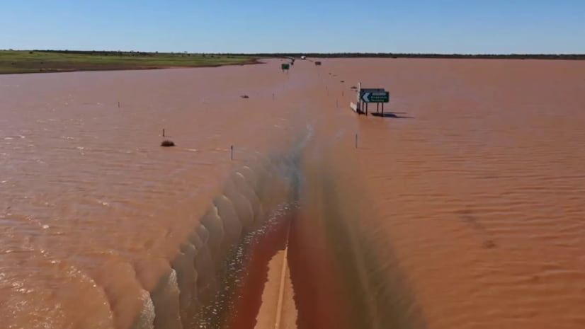
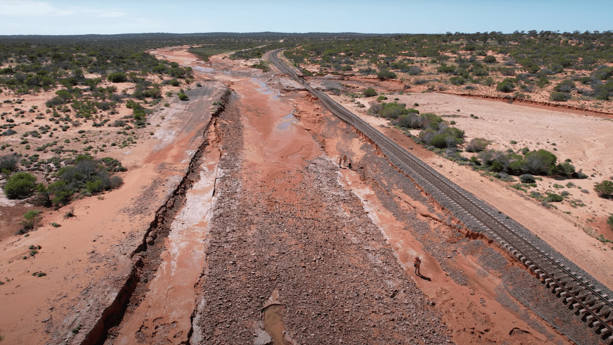
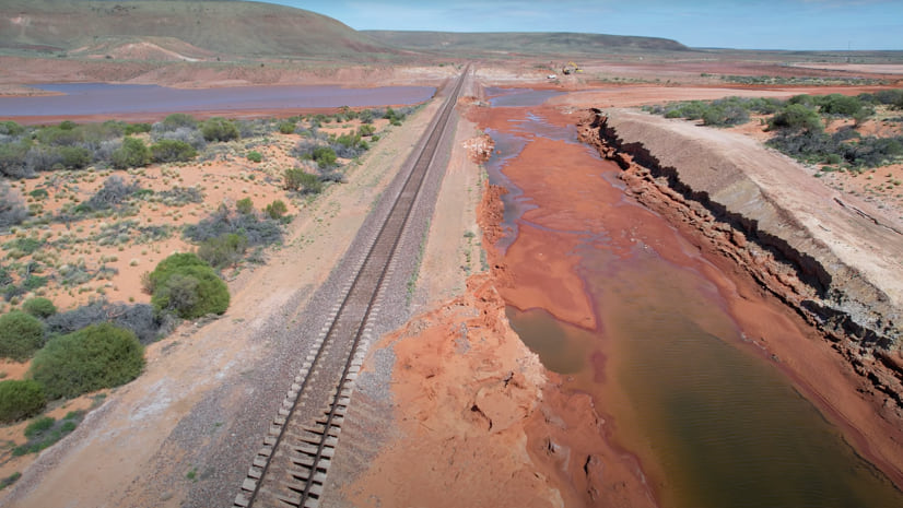
That’s when the heavens opened and let loose a record amount of rain, the fourth wettest January in South Australia and the most precipitation the area had seen since 1984. The storms submerged a key highway running north to south and severely impacted Australia’s transcontinental railway running west to east. The damage, in such an inopportune location, cut off strategic transportation routes to Western Australia and the Northern Territory, as well as residents of Coober Pedy and surrounding townships, who were unable to get out or have essentials brought in.
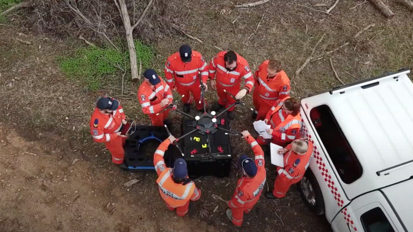
Within a few hours of the storm letting up, Jayme Moreland, the agency’s chief remote pilot at the time, had arrived in the rural outback and sent his drone airborne to assess the damage, holding his smart phone aloft to capture the slightest signal to share the images as soon as possible. Updates would inform maps, to convey road conditions and closures.
What he captured were cinematic views of the submerged railway and road from eye level and far above, to share why this corridor was now impassable. Among the video footage was a road train, typically longer and heavier than a semi-truck, towing three containers sitting stranded on the side of the highway. What had been the key thoroughfare for commerce in the days before now resembled a muddy lake.
The initial images, and those taken in the days and weeks after, helped officials and the public fully understand and assess the damage that would need to be fixed. The footage was viewed more than 750,000 times and served as a warning to motorists while the areas remained hazardous. Later, when the railway and road were repaired and reopened, follow-up footage showed the efforts that went into bringing about the welcome relief of restored mobility.
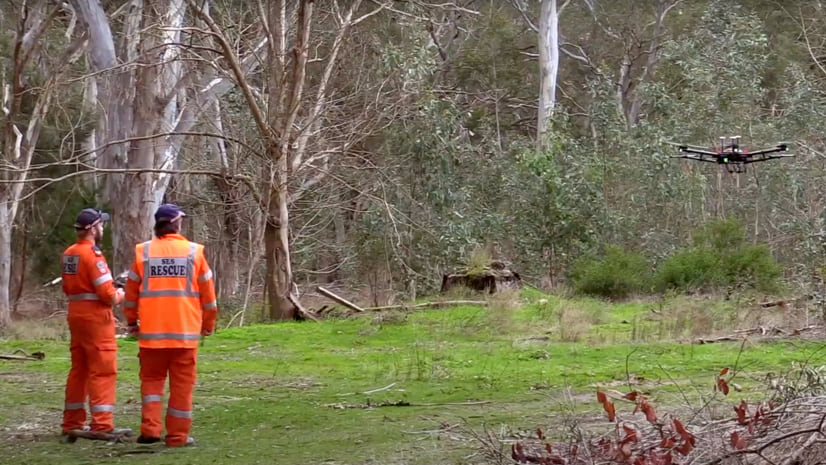
SASES—with about 100 staff and 1,500 volunteers—has become a reliable resource for its public safety peers as it has expanded its drone use. Moreland, who left SASES in October 2022 to join the South Australian Fire and Emergency Services Commission, started as a volunteer for SASES in 2012 and joined full time in 2015 to train volunteers. He realized in the intervening years that remotely piloted aircraft could serve the agency well.
“If a kid can walk into a local department store, buy a drone, and be off and flying, then why aren’t the emergency services using them?” he thought at the time. In his spare time, he investigated building, buying, flying, and testing a whole range of aircraft, eventually becoming a licensed drone pilot and integrating what he learned into his role at SASES.
Since then, SASES has used drones to better assess a series of back-to-back storms affecting a residential suburb, no longer needing to put crews in harnesses and safety systems atop roofs to take photos of damage. The agency has also supported fire agencies by using thermal cameras attached to remotely piloted aircraft to identify lingering hot spots inside trees that could flare up. Police agencies have solicited help, too, in searching for stolen vehicles in forests or to spot illegal cannabis crops.
As the state control center mobilized for January’s storms, Pulford and Esri Australia consultant Gordon Sumerling worked to quickly share the imagery Moreland was capturing, especially with the center’s mapping support team. The information would help them determine where to dedicate resources.
“One of the things that came out of this was the ability, through a dashboard, to share the information that we had and get that visibility to as high as it needed to go from a national perspective as well as a state perspective,” Moreland said.
Maps informed by these observations are still proving valuable as the country experiences more flooding events.
In other parts of the country, the first three months of 2022 accounted for a year’s worth of rain for Sydney. That was after Australia had already experienced its wettest November ever and before even more floods led to evacuation orders for tens of thousands of residents in New South Wales as recently as July.
“When heavy storm cells dump a lot of rain and don’t move quickly, it generally doesn’t end well,” Pulford said.
Traditional mitigation efforts stood little chance of holding back the water in South Australia’s outback in January. In some cases, the force of the flooding shifted the concrete culverts that were meant to protect the rails. They hadn’t been designed to withstand such force because the amount of rainfall was unprecedented. The damage to Stuart Highway and the Trans-Australian Railway “virtually stopped everything in the country from moving around,” Moreland said.
Traditional damage assessment imagery taken by piloted aircraft captured images but at far greater cost and with a less complete aerial view of the damage below. In contrast, the images captured by the remotely piloted aircraft were seamlessly stitched together using Site Scan for ArcGIS, a cloud-based tool that speeds up imagery processing and information sharing.
The images were added to a dashboard that kept track of all the damage. The imagery, maps, and charts provided everyone in the region with the context they needed to understand the impacts. The information was relayed to the National Situation Room in Canberra, which needed evidence of damage to support relief and recovery planning. That, in turn, allowed for efforts such as the airlifting of supplies to stranded residents in Coober Pedy, the remote mining town that was completely cut off by the deluge.
“The combination of a streamed video and the panoramas, to give you that top-down view, is incredibly powerful for operational visibility and situational awareness,” Pulford said. The team plans to utilize Esri’s Site Scan more broadly with more pilots since it is designed for fleets of drones. The tool allows users to create a flight plan, send it to pilots in the field, and then let the aircraft automatically fly to where it needs to go, sending images back as it collects them.
“Being able to send volunteer pilots a pre-drawn mission and they just hit ‘go’ is really foolproof,” Moreland said.
Learn more about end-to-end drone mapping.