
We’ve made tremendous improvements on the accuracy of every address, which makes a new level of location intelligence possible.
senior executive, US Census Bureau
Atri Kalluri
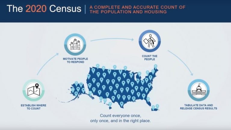
Starting in March, people living in the US will be invited to participate in the 2020 Census. Though responses can be sent online, by phone, or mail, an estimated 40 percent won’t respond. So, 500,000 temporary census workers will go door-to-door to count remaining households.
The constitutional mandate for a national census is as old as the country itself.
“Our founders knew they needed equal representation across the states,” said Ron Jarmin, deputy director of the US Census Bureau. “They mandated a census be done every 10 years to make sure that the population was counted accurately, and representation was fair.”
State and local governments are highly vested in the outcome as census results determine the allocation of billions of dollars in federal spending.
The upcoming effort marks the first time responses will be accepted online, and it’s the preferred method of response. While transforming a paper-based process offers huge efficiency gains, it comes with the challenge of safeguarding the integrity of the process and ensuring the effort isn’t being manipulated by hackers.
The Census Bureau is actively coordinating partnerships with technology companies and government agencies to stay on top of potential threats and disinformation tactics.
Securing the Census
“We are engaging with all of the big tech companies and social media platforms to identify certain behavior patterns and cyber threats that could impact the 2020 Census,” said Stephen Buckner, assistant director of communications at the US Census Bureau. “We’re also working with the federal cybersecurity officials and the Department of Homeland Security to identify process models: if this happens, then do this.”
The Census team uses a geographic information system (GIS) to drill down into geographies to understand what information is traveling across communications channels. With GIS, they can see a map-based window into activity across social media and the web, then gauge whether any messages are having an impact.
“We monitor the response rate map to see if various reputational threats, misinformation, and disinformation are displaying on our dashboards,” Buckner said. “We can see if response is slowing down or stopping in an area, and we can investigate to see if some chatter changed behavior. Then, we can take steps to mitigate that with a combination of communications outreach strategies or local partner events.”
It’s a bit early yet to determine the full scope of the cybersecurity threat, but the Census Bureau has its feelers out.
“Right now, we’re seeing more localized activity,” said Zack Schwartz, Deputy Chief of the Center for New Media and Promotions at the US Census Bureau. “Some of our dark web and deep web monitoring suggests the beginning of outside influencers, but we have yet to see that surface on social media or other outlets.”
The fact that the 2020 Census will take place concurrent with an election cycle increases the alert level.
We’ve made tremendous improvements on the accuracy of every address, which makes a new level of location intelligence possible.
Assuring a Complete Count
The Census Bureau is very aware of the public’s increasing reluctance to participate in surveys. Using GIS, its teams have created the Response Outreach Area Mapper application to dig into the geography of hard-to-count households and to reach communities of renters, recent immigrants, and others that might be reluctant to respond.
“Rich demographic detail about hard-to-count communities helps us work with our state, local, and advertising partners, to craft messages to make sure people understand that participating in the census is important and safe,” Jarmin said. “The data is used solely for statistical purposes. We don’t share it with law enforcement or other organizations that people might fear.”
To do a thorough count, the US Census Bureau needs a complete and accurate address list. Workers achieve this using GIS to gather and compile data from organizations such as the US Postal Service, state, and local governments. They also look at aerial and satellite imagery to discern changes since the prior decennial census.
“We’ve made tremendous improvements on the accuracy of every address, which makes a new level of location intelligence possible,” said Atri Kalluri, senior executive at US Census Bureau. “It will be interesting to process and analyze the response and to correlate what we know about the quality and completeness of our data with the response rates we receive.”
Read more about how GIS helps streamline Census taking and modernize official government statistics.