
October 13, 2017 |
Mark Cygan | Mapping
As commercial online mapping platforms advance in popularity and usability, national mapping agencies must keep pace. Mapmakers at Ordnance Survey Great Britain (OS) are doing just that by embracing automation to deliver current, authoritative maps and data.
As a government agency, OS provides the geospatial infrastructure for Great Britain. OS maps support emergency response, land-use planning, transport, and environmental protection. OS also serves the private sector including financial services; land and property management; and electric, gas, and water utilities.
“We’ve been mapping Great Britain for 227 years, and we map 20,000 changes every single day,” said David Henderson, managing director, Ordnance Survey Great Britain. “Our mission is changing. Our customers are demanding ever-greater currency. Now, using automated processes, we can capture data once, and we use that information across a whole range of different map and data products.”
Great Britain and OS—an international leader in map quality—recognize the economic value of up-to-date geospatial data. Henderson and the OS team realized that the agency could keep its data accurate by employing automation—the use of key algorithms to ensure accuracy for data.
The move to automation was fairly smooth because OS makes maps using modern geographic information system (GIS) technology. GIS is equipped with automated generalization capabilities that keep pace with other algorithm-intensive systems.
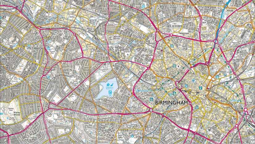
OS staff update map data by using imagery from photos captured by the agency’s own aircraft. Staff also use information from 200 surveyors who measure and map the location of every fixed physical object in the country. This data capture includes buildings, the curblines of roadways, and the precise position of every address. OS location data currently takes up two petabytes of storage capacity, and the need is growing.

Land Parcels
Recently, the OS team tailored its workflows and applied algorithms to automate the creation of land parcel data from a variety of source data types.
“We’ve been able to achieve 100 percent automation for our land parcel polygon dataset,” Henderson said. “A process that took six to eight weeks with some manual intervention now takes just 14 hours.”
In addition to saving time and money, automation proves to be more reliable than traditional practices.
“Every time a cartographer works on one of our products, they’ll do it slightly different than someone else,” said Derek Howland, business domain lead for automated map production systems at OS. “Automation gives consistency and improves the currency dramatically.”
Data as a Service
The drive toward automation comes at a time when users are demanding delivery of OS datasets as a service. This “as a service” term relates to software served up as apps on web browsers and mobile devices.
Apps connect directly to the latest data, replacing the old approach of each user having to download and maintain data. This means that end users enjoy greater flexibility. They can connect and receive authoritative, reliable data immediately within business processes and don’t need to worry about reconciling different versions of the same dataset. It also means that there are more demands placed on OS to manage its data.
“We’re seeing the digital transformation of our organization affect not just ourselves but also the relationship that we build with our customers,” Henderson said. “We provide content in far more flexible ways, allowing us to collaborate with end users to co-create content with us.”

Marking Change
Because automation has worked well with its parcel product, the OS team is applying automation to more processes and datasets. For example, team members can now supply change-only updates to customers and government partners through the agency’s OS VectorMap Local data. The automation algorithm processes new data, compares it to Great Britain’s current source of truth, and identifies what has changed.
Comparing updates to the 500 million features in the OS database requires abundant computing power. This is made possible by distributed computing in the cloud, where processes can run in parallel on many machines.
“We’re refreshing the whole country from the source data every three months,” Howland said. “Previously the average currency was three years, and some older.”
This quick refresh of data fuels the immediate demands of the day.
“The currency is key,” Howland said. “For instance, an insurance business wants to know about buildings that have changed. If it’s infill housing, they want to know how close a new building is to other buildings to assess fire risk or, if a building is close to water, to assess flood risk. It’s also critical for emergency services. If your house is on fire and you phone up the fire brigade and they can’t find you because you’re not on the map, you’re not going to be too pleased.”
Such use cases inspire agency staff to achieve innovation.
“We’re expected to be efficient and effective at what we do,” said Neil Ackroyd, interim chief executive, Ordnance Survey. “But actually, we need to be essential.”
Geospatial Modernization
British prime minister Theresa May recently established a national Geospatial Commission, aiming to align all land agency work and data. In addition to OS, this includes HM Land Registry, British Geological Survey, Valuation Office Agency, UK Hydrographic Office, and the Coal Authority.
The Geospatial Commission intends to make publicly held data easier to access and use, given its impact on the economy. The effort earmarks £40 million (about US$52 million) of new funding in each of the next two years to unlock an estimated £11 billion (about US$14 billion) of extra value for the economy every year thereafter.
With its improved data quality, the agency is looking to benefit further from automation by linking its data with other agencies. OS recently expanded its consulting work to reach a global scale, working with Ordnance Survey International to help other countries strengthen their data capture processes and realize similar economic benefits.
“It’s a sort of virtuous circle,” Ackroyd said. “Because the investment we make in Great Britain, we believe, has value to other organizations around the world. It’s not a technology company’s expertise; it’s a practitioner’s expertise.”