


October 11, 2023 |
Multiple Authors | Resilience
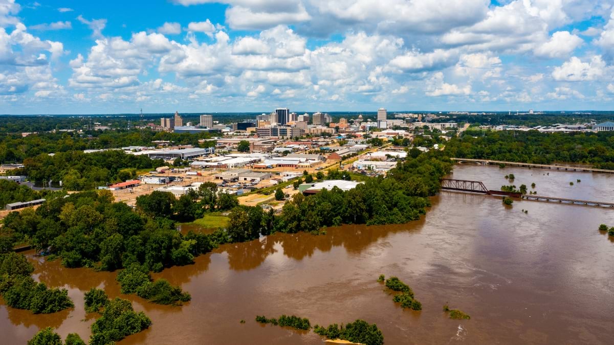
When 153,000 residents of Jackson, Mississippi, lost access to safe drinking water in August 2022, the flooding of the Pearl River brought national attention to what had been a quiet crisis. The flood didn’t contaminate the water system, but it revealed the extent of Jackson’s infrastructure failures—burst pipes, closed valves, aging equipment, and disconnected systems that made it difficult to coordinate emergency responses.
Into this challenge stepped Jordan Hillman, a city planner who had never run a water utility but understood something crucial: You can’t fix what you can’t see. Armed with geographic information system (GIS) technology and a determination to map the failures of the invisible network beneath Jackson’s streets, she would help transform one of America’s most troubled water systems.
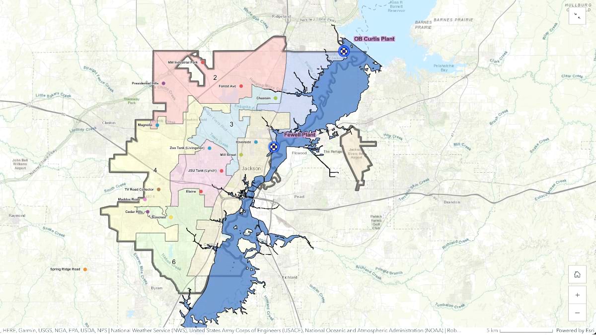
JXN Water was established by a federal court order as a third-party entity with federal funding to manage the city’s water system. While Jackson had thousands of infrastructure drawings dating back decades, they were stored in filing cabinets and on portable hard drives—organized but inaccessible to field crews that needed real-time information during emergencies.
“I went home as a planner and came back to work the next day at the water plant,” Hillman said. “The first thing I pulled out of my pocket was geographic information system [GIS] technology to track water outage calls and figure out where the network needed to be fixed.”
The situation in Jackson was intensified by decades of incomplete record-keeping, disparate systems, and disconnected departments that rarely shared information.
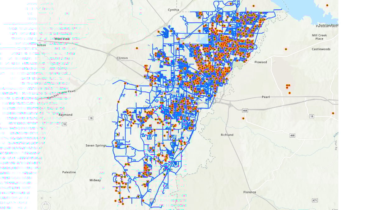
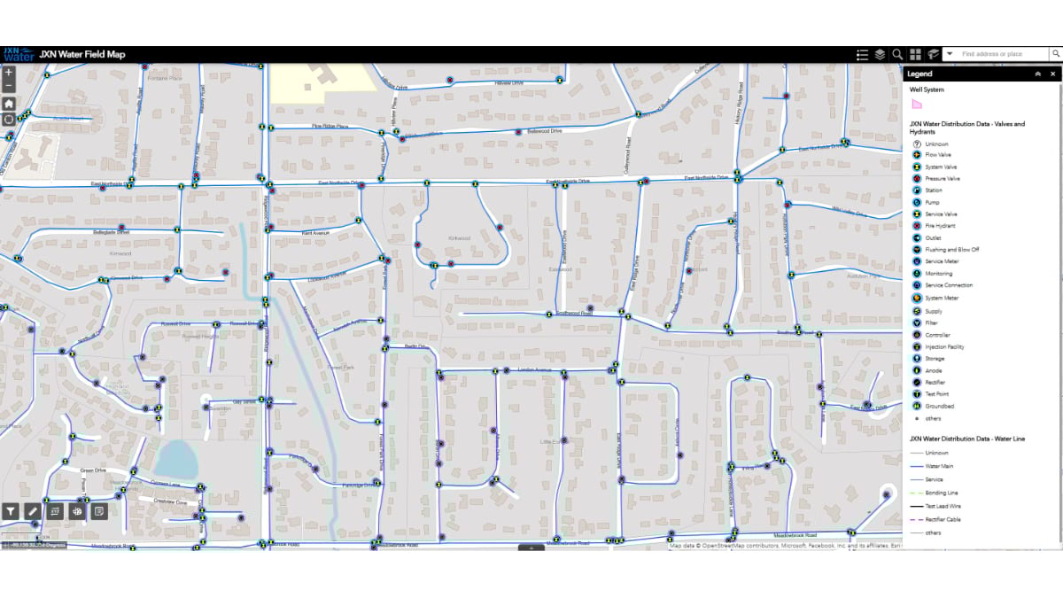
Hillman’s detective work began with tracking suspected closed valves, water quality complaints, and pressure issues by using ArcGIS Survey123 forms and ArcGIS Field Maps applications. Her priority was identifying water loss on transmission lines—the major pipes that carry water from treatment plants across the city.
Beyond noting each individual water connection, the city needed a holistic view. Water systems are intricate networks where everything connects to everything else. As Hillman learned early on, “Every time we made major progress, we broke something else in the process, putting stress back where it wasn’t before.” Water that can’t flow will find another path, often bursting weaker pipes elsewhere in the system.
She knew GIS could help and she was eager to train staff to use mapping tools to report problems, apply solutions, and track progress on thousands of repairs.
“The city, by nature, was siloed,” Hillman said. “The water plants did not talk to the distribution system.”
The city had no feedback systems for monitoring water pressure throughout the distribution network, so plant operators worked with limited information. When pressure dropped below 60 psi at the treatment plants, operators would declare a citywide boil water notice—even though many neighborhoods might have had perfectly safe water. The goal was to identify where actual pressure loss occurred so that only impacted areas would receive notices.
Numbers illustrate the dysfunction. Between 2018 and 2022, Jackson endured nine citywide boil water notices lasting a combined 129 days. Restaurants closed, schools shut down, and residents lived with constant uncertainty about whether their tap water was safe to drink.
The scale of the challenge quickly became clear. JXN Water had to fix issues on multiple fronts. Work order systems weren’t functioning. There was no reliable inventory of pipes and valves. Meanwhile, Hillman and the JXN Water team were trying to get critical transmission valves open, stop massive water losses, and understand how water actually flowed from the treatment plants to customers.
“It became pretty evident that the city was not in a position to do all the data development and mapping work needed,” Hillman said.
Hillman turned to Stantec, an engineering firm specializing in water utilities and GIS technology (see sidebar). “It all started with me handing a hard drive to a Stantec team member with over 20,000 drawings on it,” she said.
The City of Jackson had maintained an organized storage system with documented projects and atlas maps for reference. However, these infrastructure drawings—though well-organized and scanned—were stored on portable hard drives in a format that made the drawings difficult for mobile field crews to access effectively during the crisis.
“Luckily, there were some really smart people at Stantec who organized it and coded it in a way that actually made sense,” Hillman said. “We wanted to put information in the pockets of staff. They don’t need to be fishing through 15 drawings to find a pipe or valve location.”
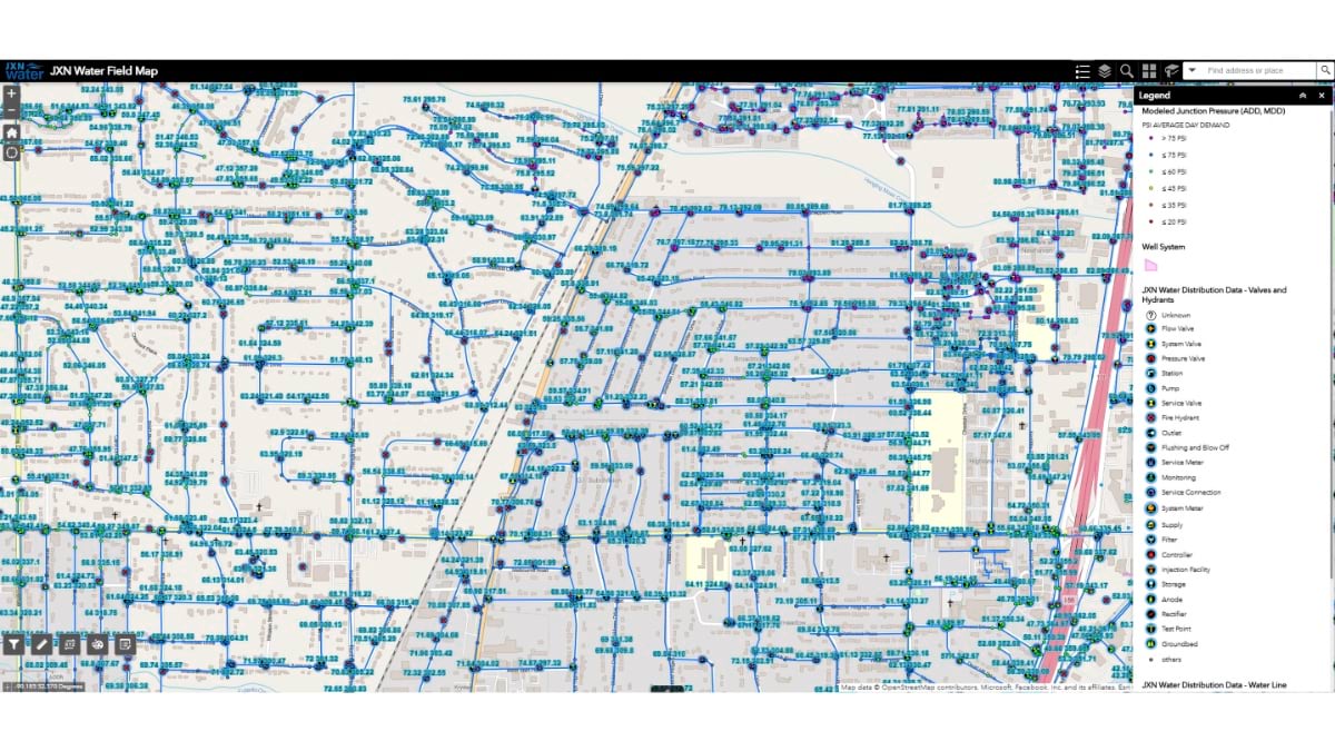
The solution combined advanced network mapping with practical field tools. Stantec helped JXN Water build mobile web applications with interactive maps that work on smartphones and tablets. “We can ask ‘Where’s the chlorine?’ and it pops that up on the map and labels it on the web app,” Hillman said. “We love it for its ease of use.”
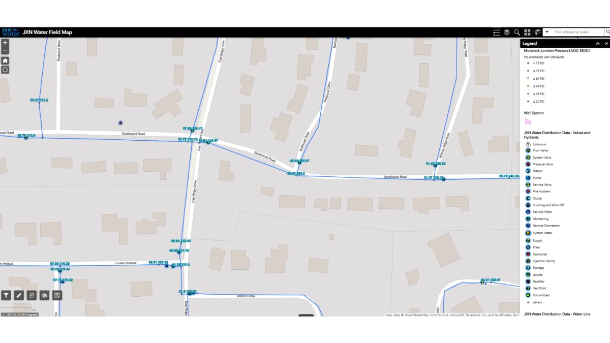
Stantec helped implement ArcGIS Utility Network to create a digital replica of Jackson’s water system. This intelligent model is fed data from a network of sensors (called a SCADA system) that constantly monitor water pressure, flow rates, and chemical levels throughout the city while smart meters track usage at every customer location.
Together these integrated technologies made a network digital twin—a real-time computer model that shows how water moves through Jackson’s underground infrastructure.
The network of sensors feeding input to the digital twin revealed patterns that had been invisible. Hillman and her team could finally see how water moved from the city’s two main treatment plants. By testing water hardness levels at different locations, they could trace which plant was supplying water to each neighborhood. They could track chlorine breakdown and aging to ensure that proper disinfection reached every customer.
Most importantly, the utility could stop managing the entire city like a single system. Operators can see real-time intelligence about every neighborhood including pressure, flow, and water quality on dashboards and interactive maps. When problems arise, the operators can isolate affected areas, automatically adjust pumps and valves, and target responses.

This comprehensive monitoring transformed JXN Water’s crisis management into strategic control. But the technology foundation was only as good as the people using it—and the real test would be whether longtime utility workers would adopt digital tools in their daily work.
“People think we had a lot of consultants come in and save us,” Hillman said. “I like to fight back on that. Most of our leadership team, including the people who work in our plants and distribution system, were here before the crisis. They just needed the right investment in themselves, the right tools, and access to do the things they already knew how to do.”
The change was dramatic and visible. Workers went from using what they called “trusty dusties”—smudged, creased drawings from the 1970s stuffed under truck seats—to confidently using tablets and phones loaded with accurate maps and real-time system data.
Instead of guessing where pipes and valves are located, the workers can see precise maps on their phones. Instead of driving back to the office to file reports, they photograph and document repairs instantly with information flowing back into the central system within hours.
“Watching people using that data—figuring out who their customer is, whether they have an account, whether they’re paying their bill—makes my heart happy,” Hillman said.
But the real transformation went deeper than individuals’ productivity. The digital tools broke down walls that had separated different parts of the utility for decades. Water plant operators and field crews, who had never coordinated their efforts, began working together daily. Meter technicians who had worked in isolation started collaborating with the billing department. Sewer teams began to help with water leak triage.
“Now I see our meter folks talking on the phone with the distribution folks, talking on the phone with whoever needs to issue boil water notices from the plant, the lab,” Hillman said. “The silos that kept people from communicating have mostly disappeared.”
The result was more than technological—it was cultural. Staff members once isolated by outdated systems now had the tools and information they needed to work as a unified team.
For JXN Water customers, the shift from crisis to reliability brought measurable improvements to daily life. The data-driven approach did more than fix infrastructure. It fundamentally changed what residents could expect from their water utility.
The most important change was a dramatic reduction in citywide water emergencies.
Since February 2023, the city has had only two citywide boil water notices lasting just two days—a 98 percent reduction from the 129 days of notices between 2018 and 2022.
When repairs are needed now, precise mapping allows JXN Water to isolate affected areas instead of shutting down the entire city. Where an outage once required over 100 water samples citywide to clear a boil water notice, the same incident now needs only 25 samples from identified affected areas. And service restoration takes hours instead of days.
The restaurant industry experienced perhaps the most significant relief. “We’ve been able to keep the restaurant community out of boil water notices since 2023,” Hillman said. Business owners who once faced impossible choices between serving potentially unsafe water or closing their doors now can serve their communities without fear of sudden shutdowns.
Across JXN Water’s network, the improvements are equally dramatic. JXN Water has repaired over 5,200 leaks in the distribution system and opened numerous valves that were mistakenly left closed. These improvements increased water pressure by more than 20 psi in parts of the South Jackson district—the difference between getting a trickle when turning on the tap and having a reliable flow. The system that once pumped over 50 million gallons daily due to massive leaks now operates efficiently at 35 million gallons of daily water production, saving an estimated $3.7 million annually.
Jackson has also become far more resilient to severe winter weather—historically one of the system’s biggest vulnerabilities. Polar vortexes and extreme freezes had previously created chaos for the water system. Massive demand spikes would prompt treatment plants to produce up to 15 million gallons more than normal, often leading to system-wide failures. Without smart metering or real-time monitoring, staff had assumed these spikes came from widespread pipe breaks. They spent precious time chasing phantom leaks through frozen ground while schools closed and residents went without water.
Now, JXN Water’s intelligent monitoring reveals the true story behind winter demand spikes: Customers were running faucets wide open to prevent frozen pipes instead of keeping the careful drip that utilities recommend.
Last winter, Jackson made it through its freeze without outages—a milestone that seemed impossible just three years ago. As Hillman put it, “When we make it through a freeze and nobody’s talking about water, that’s progress.”
For residents, these improvements translate to something simple but profound: turning on a faucet and trusting that clean water will flow consistently.
Jackson’s journey from water crisis to reliability demonstrates how the right technology in the right hands can do more than rebuild infrastructure—it can restore community trust.
What started as an emergency response has become a model for water utilities nationwide facing aging infrastructure and growing demands.
JXN Water’s success isn’t just about sensors and systems—it’s about empowering people with the tools they need to do their jobs effectively. When field crews can see the invisible network beneath their feet, when operators can respond to problems before they become crises, and when different departments can finally work together, the entire community benefits.
Learn more about how water utilities use GIS to create smart network management for water, wastewater, and stormwater.