

February 1, 2019 | Multiple Authors |
October 9, 2019
When a call comes in to 9-1-1, one of the first questions operators ask is, “What’s your location?” Contrary to location privacy concerns, 9-1-1 calls cannot always be traced. If the caller doesn’t know the exact address of their location, the 9-1-1 operator must search for it on a map—referencing nearby landmarks or businesses—before routing emergency services. In areas of new development, the caller’s address may not yet appear on the map.
To prevent confusion—and life-threatening delays—staff at 9-1-1 call centers strive to keep local maps current. In a fast-expanding region of Texas, North Central Texas Emergency Communications District (NCT9-1-1) updates its maps by using drone imagery and a geographic information system (GIS).
“We’ve got subdivisions popping up weekly that can each add another 2,000 homes,” said Rodger Mann, GIS manager with NCT9-1-1. “There’s typically one addressing person in every county and they’re overwhelmed by the pace of change.”
Aiding with Imagery Inputs
Across 13 counties surrounding the Dallas-Fort Worth metroplex, NCT9-1-1 serves 42 public safety answering points, each of which dispatches first responders. The service area covers roughly 10,000 square miles, which includes a total of 156 municipalities that are home to 1.6 million people.
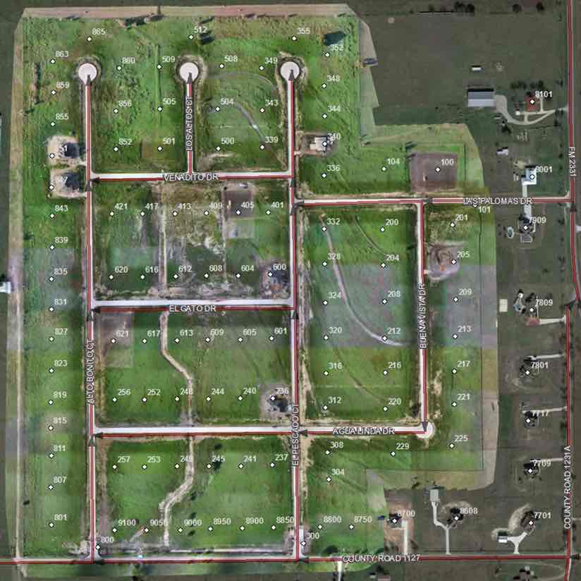
One of the counties NCT9-1-1 serves is Collin County. It includes the fast-growing city of Frisco, which has received many large business relocations. According to the US Census Bureau, the county grew by 33,753 residents from 2017 to 2018, making it the fourth-fastest growing county in the US. In that same time span, NCT9-1-1 added 15,904 new Collin County addresses—a spike of 7 percent in one year.
To keep up with this growth, NCT9-1-1 partnered with satellite imagery provider Maxar (formerly DigitalGlobe), which provides fresh local imagery every 30 days. NCT9-1-1 also invested in drones to quickly fly and collect imagery for new subdivisions, giving a current picture of what is where.
“We collect and share imagery with addressing authorities to help them speed up the addressing process,” Mann said. “We also serve the imagery out in a dispatch environment so that the 9-1-1 telecommunicators can use it to guide first responders and help people in crisis.”
With so much growth in their region, the staff members at NCT9-1-1 keep busy.
“Thankfully, we live in a digital era where we can do a lot of things remotely and we don’t have to travel out to every county,” said Bruno Blanco, GIS specialist at NCT9-1-1. “It can take several hours to travel from one end of our NCT9-1-1 region to the other, depending on traffic.”

Flying to the Corners of Each County
The drone team at NCT9-1-1 consists of four people who work to capture construction as it’s being built (pending landowner permission) so that staff in 9-1-1 dispatch centers can see new roads and residences. Current imagery gives the team peace of mind, knowing, for example, that they’re dispatching vehicles to a new subdivision rather than to what would otherwise appear on the map as an open field.
“The drone program has been a dream of ours for two or three years,” said David Dean, 9-1-1 GIS project coordinator at NCT9-1-1 and lead on the drone program. “Many of our counties purchase new imagery every two years. With our drones, we can fly one day, bring imagery back for processing, and then share it within days.”
In addition to capturing new subdivisions, the drones are used to inspect the NCT9-1-1 system of microwave towers that provide a redundant communication network to its fiber and 4G LTE networks—ensuring that all calls go through.
“Communications outages are a big concern in the 9-1-1 community,” Mann said. “Fiber cuts do occur pretty often, and they can take out a dispatch center for days. We recently added the microwave network to make sure that kind of thing doesn’t happen to any of our counties.”
In the interest of providing more precision on the origin of calls, the Federal Communications Commission has been pushing mobile phone carriers to provide Z-axis (height) data coming from handsets. NCT9-1-1 is testing the use of drones to create 3D data for tall buildings.
“It’s a new concept in public safety to be able to see where someone is calling from within a building,” Mann said.
Achieving a Shared Awareness
NCT9-1-1’s ability to collect and share the latest imagery is a fairly recent milestone.
“We had really outdated imagery until recently, and we’ve long had the need to provide better resolution and more up-to-date inputs for our first responders and 9-1-1 telecommunicators,” Mann said. “We just didn’t have the manpower or expertise to build these datasets and workflows.”
NCT9-1-1 worked with Esri Services to create a semiautomated process using ArcGIS Image Server for gathering imagery inputs and combining them into what is known as mosaic datasets, then publishing imagery services that can be displayed in a variety of applications.
This refreshed imagery helps county addressing personnel and NCT9-1-1 troubleshoot and conduct quality controls on the addresses the agencies receive.
“We’ve had to go in and align data and details to make them reflect what’s on the ground, because our previous imagery wasn’t as accurate,” Blanco said. “More accurate 9-1-1 data eventually leads to better call routing and saves lives.”
The team at NCT9-1-1 is careful to document its processes and share essential workflows with other programs.
“That’s a nice benefit of doing this work,” Mann said. “It doesn’t just benefit us—it also benefits our neighbors.”
Learn more about using imagery to turn earth observations into powerful insights.

February 1, 2019 | Multiple Authors |

June 7, 2018 |

February 7, 2019 |