
November 7, 2019 |
John Beck | Public Safety
September 11, 2025
Critical data about missing children in the US can now reach local communities through an investigative mapping tool once available only to law enforcement.
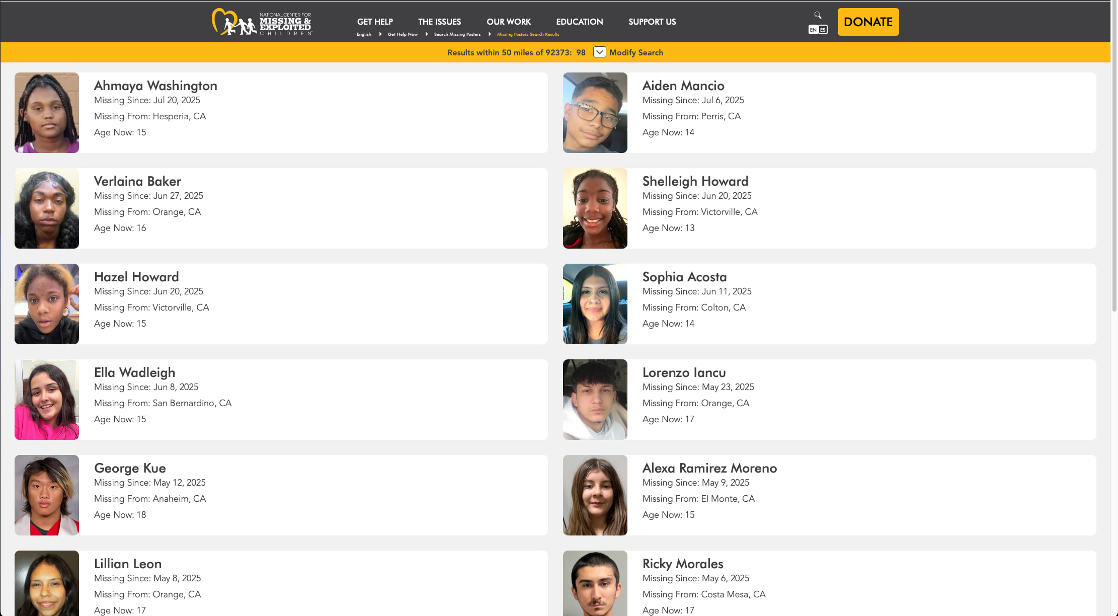
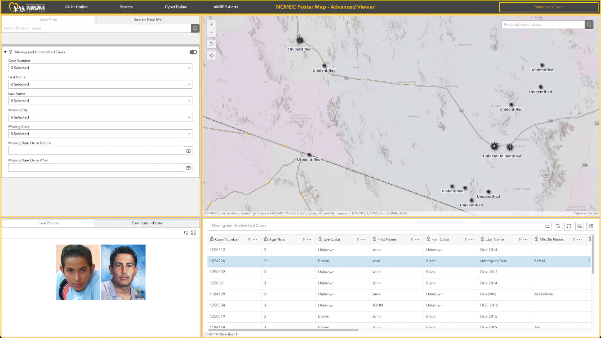
The National Center for Missing & Exploited Children (NCMEC) manages an interactive site called Poster Map. Anyone can click into the map to see the faces of children who have disappeared in their area and reach a tip line if they have helpful information. The map serves as a modern version of missing child posters or 1980s milk carton ads.
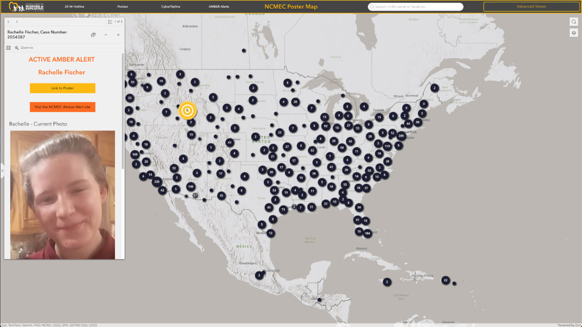
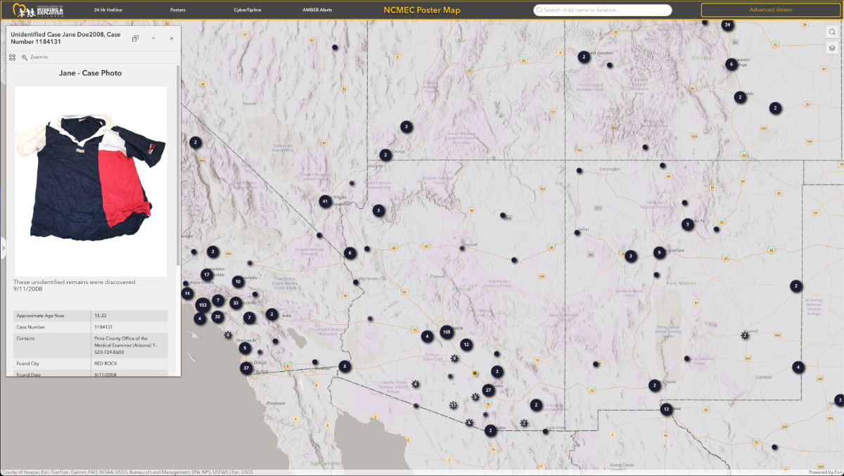
Zooming into a region on the Poster Map, dots appear representing familiar places—the local mall, a town’s main roads, nearby neighborhoods. Clicking on a dot surfaces a missing child poster. Using the search tool, people can also see missing child cases and active AMBER Alerts across the country.
“Every missing child case is a local disaster for that family, for that neighborhood, for that community,” said John E. Bischoff III, vice president of the Missing Children Division at NCMEC. The first 24 hours are crucial, but many cases extend far longer. Without sustained public attention and engagement, leads go cold and memories fade. NCMEC developed the Poster Map to help maintain visibility.
“‘This child has been missing for 10 years and that happened five miles from my house. I had no idea,’” said Bischoff, describing a typical reaction.

For 40 years, NCMEC has been collecting data in a national clearinghouse of records used to assist the 18,000 federal, state, and local law enforcement agencies across the US. The agencies already apply modern mapping from geographic information system (GIS) technology to plot search areas, track movement patterns, and coordinate resources. Until recently, NCMEC data hasn’t been as easy for the public to access. Instead, it was locked in databases and static information products used only by investigators.
Today, NCMEC is building transparent location-based targeting with advances like Poster Map. Another innovation uses QR codes to surface alerts about missing child cases within 50 miles of where the code is scanned. The codes appear on items such as water bottles sold at airports or gas stations and link to the Poster Map.
The QR code approach helps solve a fundamental problem with missing child information: static posters can’t be updated fast enough to reflect recovered children or emerging cases.
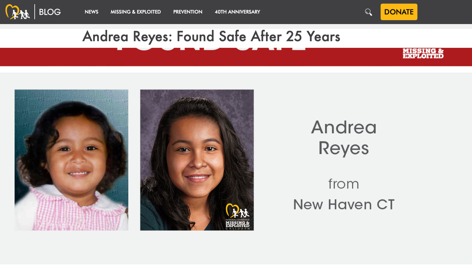
The organization processes 80 to 90 new cases every day. The majority of children are found within the same city center where they disappear. Often someone who lives, works, or shops in the area has seen or heard something that can help locate them.
Poster Map helps create those connections and brings a national tragedy closer to home. Missing children aren’t numbers on a report. They’re someone’s daughter, son, sister, or brother who lives down the street. Instead of showing overwhelming national statistics, the map focuses on what maters most: the specific children missing in specific communities where someone might have the vital information that brings them home safely.
Stacy Garrett, NCMEC vice president of content and community engagement, who led the poster redesign effort, sees the Poster Map as “the biggest jump forward in terms of applying technology to invite people to engage with our posters.”
Poster map serves two distinct audiences with careful intentionality. “One is for everyday citizens who want to see what’s happening in their community,” Bischoff explains. “The other is for more engaged people who take it upon themselves to really dive into missing child cases, looking for linkages between cases.”
The standard view provides simple navigation with basic map functions for people who want straightforward access to local information.
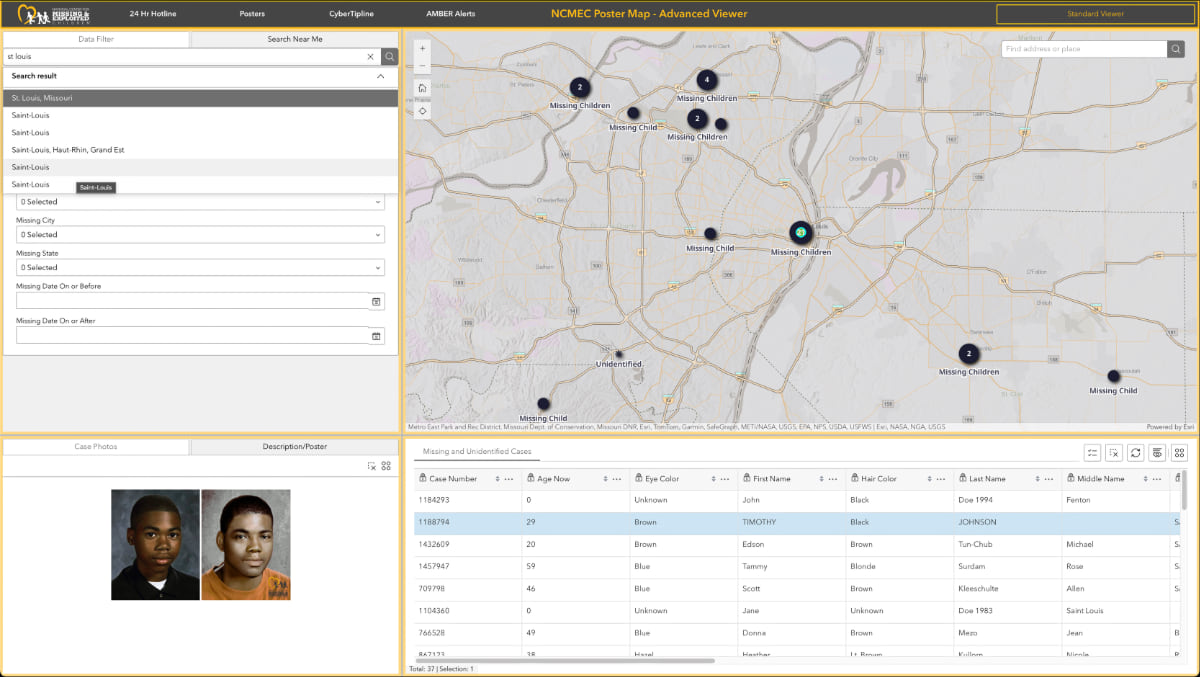
The advanced view lets users search by date, location, and distance from a specific area. It’s designed for people who dedicate significant time to missing persons cases—researchers, online investigators, podcast audiences, and those who focus on unsolved cases. These committed volunteers have become valuable allies in NCMEC’s work. The organization has seen online communities provide breakthroughs in cases where conventional investigations had reached dead ends.
“We’ve seen kids returned and found and cases resolved because people on the internet were doing research and trying to move things forward themselves,” Bischoff said. He noted that these dedicated volunteers possess something law enforcement often lacks—unlimited time to analyze patterns, cross-reference cases, and pursue hunches across jurisdictional boundaries.
The public map is just the beginning. “We want to build a map that’s specific for law enforcement that has many other different overlays on it,” Bischoff said. That version will include sex offender registries, attempted abduction patterns, and other law enforcement-specific data layers that aren’t appropriate for public view.
One of the advanced capabilities of Poster Map is a feature that allows data to be streamed across platforms but not downloaded. This ensures a single source of truth from NCMEC to third-party applications and systems. All sites and tech tools pulling in NCMEC data are automatically updated.
When a child is found, their information gets removed from Poster Map and all connected platforms. The systematic removal of that data prevents the painful scenario where a recovered child’s information continues circulating long after they’ve returned home. For families and reunited children, it means their ordeal doesn’t follow them indefinitely across the internet.
To achieve this level of functionality and data governance, NCMEC developers built an application programming interface (API) that replaces outdated RSS feeds. The API allows credentialed developers to pull new records automatically—once an hour or every few hours—preventing the version control issues that often results from downloadable datasets.
“Once we take it off of our website, the API is updated, and any programmer that was pulling from that, it automatically comes out of their feed too,” Bischoff said.
This strategic approach to data management transforms NCMEC from an information provider into an information ecosystem orchestrator. It reflects NCMEC’s understanding that their authority as the trusted source for missing child information is perhaps their most valuable asset.
In an era of deepfakes and AI-generated missing child hoaxes designed to generate clicks and engagement, NCMEC’s verified records are becoming even more critical.
Each day a child is missing increases the risk of harm, while each person who sees their face increases the chance of recovery. The Poster Map represents hope that better visualization will lead to faster safe returns, but everyone involved understands they’re still fighting an uphill battle.
As NCMEC launches this tool publicly, they’re issuing a call to action. They need concerned people willing to look at the faces of children who have gone missing in their communities.
Today, NCMEC teams are also exploring cross-border applications of the Poster Map idea. They recently connected with Tribal GIS to address missing and murdered indigenous people and the need for tools that transcend jurisdictional boundaries where cases often stall.
What NCMEC knows for certain is that location intelligence changes perspective, turning individual missing child posters into community concerns. Someone somewhere might recognize a face and make the call that brings a child home.
“We’ll never forget about a missing child,” Bischoff said. “We’ll be done when all the kids are home.”
Visit the interactive search missing children poster map to see cases near you. Learn more about how law enforcement trust GIS for mapping and spatial analysis to keep our communities safe.